
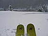
Guess I'm glad CB is at 9500'- no rain, but it has been snowing since I woke up. It's not necessarily worth the drive for you front rangers, but Paradise bowl and Ruby chief are the half-decent runs open right now.
Results 176 to 200 of 259
-
11-30-2007, 08:15 PM #176

 Jack's got my back
- Join Date
- Jan 2005
- Location
- cb, co
- Posts
- 5,326
-
11-30-2007, 08:23 PM #177
 Did it snow last night?
- Join Date
- Nov 2004
- Location
- Eagle, CO
- Posts
- 2,277
Powday with girls tomorrow. Powday with the bros on Sunday.

-
11-30-2007, 09:51 PM #178
 Registered User
- Join Date
- Oct 2003
- Location
- Aspen
- Posts
- 9,564
Sooo, when's the colder air coming? Still 39 degrees outside 39 Degrees.
edit - make that 41Last edited by funkendrenchman; 11-30-2007 at 09:59 PM.
-
11-30-2007, 09:52 PM #179
 ExteriorDecorator
- Join Date
- Nov 2005
- Location
- Down In A Hole, Up in the Sky
- Posts
- 36,513
According to Blurred, it is actually 28 degrees.
Forum Cross Pollinator, gratuitously strident
-
11-30-2007, 10:52 PM #180
Registered User
- Join Date
- Oct 2003
- Location
- Aspen
- Posts
- 9,564
Update 9:43 pm
weather.gov
National Weather Service
Watches, Warnings & Advisories
Local weather forecast by "City, St" or zip code
2 products issued by NWS for: Aspen CO
--------------------------------------------------------------------------------
Winter Storm Warning
URGENT - WINTER WEATHER MESSAGE
NATIONAL WEATHER SERVICE GRAND JUNCTION CO
943 PM MST FRI NOV 30 2007
...MAJOR WINTER STORM WILL BRING HEAVY WET SNOW AND STRONG WINDS
TO THE MOUNTAINS THROUGH SATURDAY NIGHT...
.VERY MOIST SOUTHWEST FLOW WILL TRACK OVERHEAD AND BRING WIDESPREAD
SNOW AND WIND TO THE MOUNTAINS OF EASTERN UTAH AND WESTERN
COLORADO TONIGHT THROUGH SATURDAY NIGHT. A LAYER OF WARM AIR ALOFT
WILL KEEP SNOW LEVELS ABOVE 9000 FEET FOR MUCH OF TONIGHT...BEFORE
COLDER AIR ARRIVES ON SATURDAY AND ALLOWS SNOW LEVELS TO DROP. RAIN
AND SNOW ARE EXPECTED AT LOWER ELEVATIONS WITH THE POTENTIAL FOR
SIGNIFICANT SNOWFALL ACROSS MUCH OF THE HIGHER VALLEYS AS WELL
STARTING MIDDAY SATURDAY. SOME OF THE COLDER VALLEYS NEAR VERNAL
UTAH AND EAGLE COLORADO WILL EXPERIENCE SNOWFALL AS COLD AIR
REMAINS TRAPPED IN THESE VALLEYS. MODERATE TO HEAVY RAINFALL IS
ALSO POSSIBLE ACROSS LOWER ELEVATIONS OF SOUTHEAST UTAH AND
SOUTHWEST COLORADO WHERE FLASH FLOODING IS POSSIBLE. THE STORM IS
EXPECTED TO BE MOVING EAST OUT OF OUR AREA BY SUNDAY MORNING.
COZ003-004-010-013-UTZ023-025-011245-
/O.CON.KGJT.WS.W.0008.000000T0000Z-071202T1200Z/
ROAN AND TAVAPUTS PLATEAUS-ELKHEAD AND PARK MOUNTAINS-
GORE AND ELK MOUNTAINS/CENTRAL MOUNTAIN VALLEYS-FLATTOPS-
EASTERN UINTA MOUNTAINS-TAVAPUTS PLATEAU-
INCLUDING THE CITIES OF...RIO BLANCO...COLUMBINE...TOPONAS...
ASPEN...VAIL...SNOWMASS...BUFORD...TRAPPERS LAKE...MANILA...
DUTCH JOHN
943 PM MST FRI NOV 30 2007
...WINTER STORM WARNING REMAINS IN EFFECT UNTIL 5 AM MST SUNDAY...
A WINTER STORM WARNING REMAINS IN EFFECT UNTIL 5 AM MST SUNDAY.
RAIN AND SNOW WILL SPREAD ACROSS THE AREA FROM SOUTH TO NORTH
OVERNIGHT WITH SNOW LEVELS NEAR 9000 FEET. THE SNOW LEVELS WILL
LOWER ON SATURDAY TO THE VALLEY FLOORS AS COLDER AIR ARRIVES. THE
SNOW WILL THEN BECOME WIDESPREAD AND INTENSIFY SATURDAY AFTERNOON
AND SATURDAY NIGHT. TOTAL SNOWFALL ACCUMULATIONS IN EXCESS OF ONE
FOOT ARE POSSIBLE ABOVE 8000 FEET BY EARLY SUNDAY MORNING.
IN ADDITION...GUSTY SOUTHWEST TO WEST WINDS FROM 20 TO 35 MPH WILL
CREATE AREAS OF BLOWING SNOW. THIS WILL REDUCE VISIBILITIES TO
LESS THAN ONE MILE...ESPECIALLY OVER THE HIGHER MOUNTAIN PASSES.
A WINTER STORM WARNING MEANS SIGNIFICANT AMOUNTS OF SNOW...
SLEET...AND ICE ARE EXPECTED OR OCCURRING. STRONG WINDS ARE ALSO
POSSIBLE. THIS WILL MAKE TRAVEL VERY HAZARDOUS OR IMPOSSIBLE.
$$
--------------------------------------------------------------------------------Last edited by funkendrenchman; 11-30-2007 at 10:55 PM.
-
11-30-2007, 10:58 PM #181
 Rollin with the Tide
- Join Date
- May 2006
- Location
- Eagle County
- Posts
- 12,637
ok so far this is the worst winter storm ever. 39 in Vail and rainy at 5. We left headed Keystone (more on that later), at 5:30 on Vail Pass it was puking snow and 28 degrees. Got to Dillon and had dinner, just some flurries. Got to Keystone and started skiing at 7 and it was clear and 35. Left Keystone at 8:30 and it was clear and 38. Copper was cloudy and 38, Vail Pass was flurries and 35. Back home in Vail and it is cloudy a sprinkle or two of rain and 38. Great fucking storm so far!
36 Hours of Keystone was the most ridiculous junk show of people....EVER. Oh my god did that suck.ROLL TIDE ROLL
-
11-30-2007, 11:13 PM #182
 poor, ugly, happy
- Join Date
- Apr 2006
- Posts
- 1,792
Been snowing in Leadville since 11 or so this morning. Maybe 6+ inches or so in my driveway. Still flurrying a bit. Hoping it picks back up tonight like the weatherman says it's supposed to.
Ride Fast, Live slow.
We're mountain people. This is what we do, this is how we live. -D.C.
-
11-30-2007, 11:20 PM #183
rain
- Join Date
- Dec 2005
- Location
- Republik Indonesia
- Posts
- 7,288
LoL what did you expect?!? Originally Posted by montanaskier

I had tons of fun for the few hours I was there, and am headed back 'round 2am-ish.
psst
the storm isn't even here yet.
Check the radar.
-
11-30-2007, 11:33 PM #184
Registered User
- Join Date
- Oct 2003
- Location
- Aspen
- Posts
- 9,564
5 degree temp drop in the last 45 minutes.
And yes, there is A LOT more to this storm!!!!
-
12-01-2007, 12:33 AM #185

 Registered User
- Join Date
- Apr 2004
- Location
- Three-O-Three
- Posts
- 15,674
Wow, its kind of depressing reading the posts from all the idiots on here. Just let the snow fall....
-
12-01-2007, 06:15 AM #186
Rollin with the Tide
- Join Date
- May 2006
- Location
- Eagle County
- Posts
- 12,637
think I see a flurry here in Vail.....wait....wait....nope still raining at 5am.
ROLL TIDE ROLL
-
12-01-2007, 06:46 AM #187
poor, ugly, happy
- Join Date
- Apr 2006
- Posts
- 1,792
Damn. Just looked outside and as a quick guess, there's close to 10 inches on my porch railing at 10,000 feet. Looking forward to today.
Ride Fast, Live slow.
We're mountain people. This is what we do, this is how we live. -D.C.
-
12-01-2007, 07:06 AM #188
 Lord of Bones
- Join Date
- Jan 2006
- Location
- Saaaan Diaago
- Posts
- 3,489
A foot of wet shit on the ground here at the Grand Lodge in Mt. Crested Butte. As temps cool, it will mean a soft base with fluffy stuff on top. That sounds good, right?
Wolf Creek Pass: 20 inches forecasted today, and 10-16 tonight...
Wholly effin' shit."I said flotation is groovy"
-Jimi Hendrix
"Just... ski down there and jump offa somethin' for cryin' out loud!!!"
-The Coolest Guy to have Ever Lived
-
12-01-2007, 07:15 AM #189
Banned
- Join Date
- Apr 2007
- Posts
- 2,315
Snow out West!!! Praise Ullr, now we won't have to listen to all the whinning anymore. Still kind of a ? for New England. Off Sunday to Thursday, house offer just accepted, and it's gonna snow...alot. Life=Good
-
12-01-2007, 07:38 AM #190
 mmmmm.....California

- Join Date
- Nov 2004
- Location
- San Francisco, CA
- Posts
- 2,139
Well woke up nice an early to check to see if anything has fallen and it looks like this storm is damn slow.......if we talked about this for 7 pages and it turns to nothing up here i'm gonna be pissed.....Looks like Aspen is getting some good snow now though.....enjoy Funken.....send it up here to SuCo please.....
-
12-01-2007, 07:46 AM #191
Registered User
- Join Date
- Oct 2003
- Location
- Aspen
- Posts
- 9,564
Silverton update:
December 1 updated
WE ARE CLOSED!!! 24" OF NEW IN THE PARKING LOT!!! POWER OUT, HIGH WINDS, COUNTY ROAD VEHICLES STUCK ON ROAD, GO TO PURG,T-RIDE,& WOLF TODAY!!!!
36" in 48 hours
-
12-01-2007, 08:17 AM #192
Rollin with the Tide
- Join Date
- May 2006
- Location
- Eagle County
- Posts
- 12,637
puking here in Vail finally.....I never had any doubts.
ROLL TIDE ROLL
-
12-01-2007, 08:32 AM #193
 3 dimensional skiing
- Join Date
- Jun 2004
- Location
- Pemberton, BC
- Posts
- 2,356
a few inches on the ground in Fraser (730am). but snowing hard.
-
12-01-2007, 08:35 AM #194
 Transplanted Mainiac
- Join Date
- Sep 2004
- Location
- Ten Mile Vistas
- Posts
- 4,042
I woke up to 6"-8" on the ground at my house in Alma and it's still coming down. Was hoping for more than 1" at Breck, but this is typically when the moisture comes out of the SW. We'll take anything we can get.
Old's Cool.
-
12-01-2007, 08:37 AM #195
 no bumps, no fat chicks
- Join Date
- Nov 2004
- Location
- fighting cock, ak
- Posts
- 1,631
wolf creek reporting 32" and the cam shows that it's still coming down pretty good. i hope vail gets at least a foot out of this.
-
12-01-2007, 09:01 AM #196
 <<<<<Fair Warning
- Join Date
- May 2006
- Location
- Wyoming
- Posts
- 742
Hey Colorado, we stole your snow. Atleast the dry shit. Its all here. It's amazing.
Originally Posted by TWINS
-
12-01-2007, 09:05 AM #197
Registered User
- Join Date
- Jan 2005
- Location
- Exit, Colorado
- Posts
- 591
rained all night in Salida. the webcams on Monarch pass don't look that great yet. More coming today? Hopeing....
-
12-01-2007, 09:14 AM #198
 Carpe Skiem
- Join Date
- Oct 2004
- Location
- Colyrady
- Posts
- 3,780
Big in Southern CO and very little Front Range so far.

-
12-01-2007, 09:49 AM #199
 TR Junkie
- Join Date
- Mar 2004
- Location
- Reno
- Posts
- 2,434
I am talking out my ass sitting in Reno, and dont know much about your storm, but.......
Raining at the base can be a GREAT thing! That means paste all over the mountain. Happens at Squaw all the time and allows amazing lines to be skied, and a great, safe, base to start the season.
I think this is could be a good start for you guys.Donjoy to the World!
-
12-01-2007, 10:00 AM #200
Jack's got my back
- Join Date
- Jan 2005
- Location
- cb, co
- Posts
- 5,326
Nope, you're exactly right. This was just what the doctor ordered- over a foot and counting of wet snow (CAIC said something like 3" of h2o content in the 17" reported at WC pass). Time to go schred the landing strips... Originally Posted by Huckwheat

 Reply With Quote
Similar Threads
-
Comin' to Colorado!
By KansasBoarder in forum General Ski / Snowboard DiscussionReplies: 0Last Post: 02-09-2007, 10:46 AM -
Co ski conditions bitchen
By skifasttakechances in forum General Ski / Snowboard DiscussionReplies: 68Last Post: 11-17-2006, 12:36 PM -
Colorado Mags
By Stymie in forum General Ski / Snowboard DiscussionReplies: 9Last Post: 10-31-2006, 07:57 PM -
Colorado Randonnee Race Series
By Alpine Dreams in forum General Ski / Snowboard DiscussionReplies: 3Last Post: 07-09-2006, 07:12 PM -
CSAW Colorado Snow and Avalanche Workshop - The Report: Damned Good!
By Summit in forum TGR Forum ArchivesReplies: 1Last Post: 10-16-2003, 05:00 AM

Bookmarks