
People skin stupid out there fer sure. Canvas wreckers. And tell mumsy to get gtfo of the ecrc or i'll tell dad.Originally Posted by tBatt

Rog
Results 226 to 250 of 688
Thread: Wasatch Conditions 13/14
-
01-14-2014, 04:28 PM #226
 Banned
- Join Date
- Dec 2009
- Posts
- 7,167
-
01-14-2014, 04:46 PM #227
 Utarded

- Join Date
- Mar 2006
- Location
- SLC
- Posts
- 2,577
Why would they die? Just curious. Originally Posted by tBatt
-
01-14-2014, 04:51 PM #228
Banned
- Join Date
- Oct 2003
- Location
- In Your Wife
- Posts
- 8,288
Don't know that if the road is open Superior is totally safe to ski? Duh. Originally Posted by tBatt
-
01-14-2014, 06:10 PM #229
Registered User
- Join Date
- Aug 2009
- Posts
- 3,449
the real story is all the fine traxs down!!!!!!
-
01-14-2014, 06:25 PM #230
Banned
- Join Date
- Dec 2009
- Posts
- 7,167
barf. ya maybe spindrift and a coupla others. Originally Posted by Slaag Master
rog
-
01-14-2014, 08:28 PM #231
 Registered User
- Join Date
- Feb 2010
- Location
- Park City
- Posts
- 316
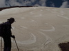
Less wind damage than I was expecting out there. South was done by the afternoon. Tests have been less energetic than I would expect but as the forecast said I guess thats why its a persistent weak layer. Seams like lots of spacial varability out there.
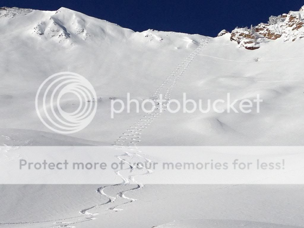
Fabby getting some...
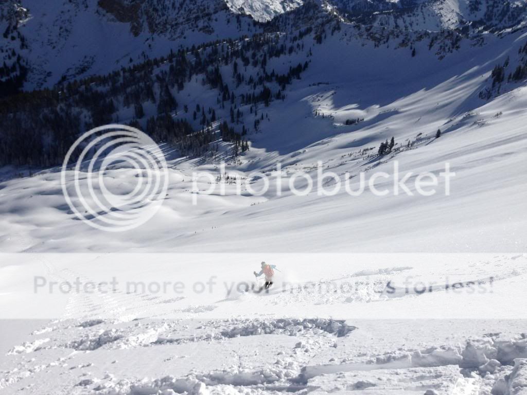 "Officially known as Highway U-210, more commonly known as Little Cottonwood Canyon and unofficially acknowledged as the epicenter of the greatest snow on earth." Andrew McLean
-
01-14-2014, 08:35 PM #232
 Invented Yoga
- Join Date
- Apr 2011
- Location
- Sodium Chloride, Honest Abe
- Posts
- 327
Nice tracks.
-
01-14-2014, 08:39 PM #233
Banned
- Join Date
- Dec 2009
- Posts
- 7,167
AND TYFALK!!! BRILLIANT!!!
rog
-
01-14-2014, 09:17 PM #234
Registered User
- Join Date
- Sep 2005
- Location
- 11,132
- Posts
- 453
Because the winds at 11K' have been in the 30's, 40's, and 50's out of the W and NW for several days; because the place where they gained the ridge is east facing, not only making it directly leeward to the prevailing winds but also a likely spot for persistent weak layers to exist; because we've had over 40 inches of snow with several density changes and a freezing rain event over the last week; because our significant new snow load was seeing its first sunlight... Originally Posted by JTrue
Superior is an awesome run, and there are a lot of days when it can be skied safely, even when it has lots of fresh snow; I think there are days when skinning to the top up the S face is ok as well--fuck Rog!--but insodoing one misses out on a classic approach up the E ridge. Of course, I would have wanted nothing to do with N facing Cardiff Peak or E facing LSB this morning. Nevertheless, it took a pretty flippant attitude toward general snow and avalanche awareness, and our particular conditions today, to go hang out on the S face of Superior for a couple hours, and to punch it all the way to the ridge, on a steep, east-facing slope at 11K', while the winds were still nuking at that elevation. I think its generally bad practice to criticize other skiers' tolerance for risk, or second guess other peoples' forecasting, but I cannot see how any sort of informed thought process about avalanches and current conditions went into approaching a huge, leeward slope, that anyone with a compass and a clue should suspect of harboring persistent weakness, from the bottom, on a day like today.
S facing LCC is probably the most popular and visible BC skiing destination in the US, and lots of ridiculous shit goes on there all the time; that the ridiculous shit usually goes unpunished by natural consequences is absorbed by a whole lot of people skiing at Alta and Snowbird, and that compounds the amount of people opting to ski up there. I think that professional avalanche forecasters are in the right to avoid explicitly criticizing avalanche victims' decisions, but the examples provided in full view of so many people in places like Superior are so influential that I think its essential to have dialogue about things we consider particularly egregious.
It cannot be said enough: a lot of people look at S facing LCC as "controlled" terrain, and for the purpose of skiing, it is nothing of the sort. It might--but only might--be a decent bet against a deep slab avalanche pulling out at your feet as you drop into the high triangle, but it means very little about whether you will get caught off guard by a wind slab that grew overnight as you wallow up toward the ridge from below, which, if it had happened to today's party on the S face, would have most likely terminally fucked them. And since I'm already pontificating about skiing and avalanches on Mt. Superior, it should be stated that Suicide chute is a giant NE facing avalanche path, and wandering up there when we're on the cusp of a large avalanche cycle makes you look like one of those snowmobilers in Logan.Last edited by Christopher3000; 01-14-2014 at 10:54 PM.
-
01-14-2014, 11:30 PM #235
Utarded
- Join Date
- Mar 2006
- Location
- SLC
- Posts
- 2,577
Thanks Christopher. Originally Posted by Christopher3000
-
01-14-2014, 11:46 PM #236
observing free range rude
- Join Date
- Aug 2012
- Location
- below the Broads Fork Twins
- Posts
- 5,772
Are we talking E shoulder of Superior or skiers right, E face of Superior (just north of suicide)?
-
01-15-2014, 12:11 AM #237
Registered User
- Join Date
- Nov 2011
- Posts
- 7
Thanks x2 Christopher although the decent family I spoke to in Logan today actually knew better than to get onto steep wind loaded slopes, they didn't know you could trigger things from such a distance on flatter terrain. Careful out there Fabby.
Brett Kobernikavalanche know-it-all jong
-
01-15-2014, 12:35 AM #238
 Old Man and the Ski
- Join Date
- Apr 2007
- Location
- Tahoe
- Posts
- 16,326
thanks everybody but it looks like the mutt has a place to stay here after all. was bringing him since his usual mom when i'm gone is coming with us. should be skiing either backcountry or canyons on the 20th and maybe 21st. maybe again on the 25th but fisher towers is a possibility too.
powdork.com - new and improved, with 20% more dork.
-
01-15-2014, 07:10 AM #239
 Registered User
- Join Date
- Dec 2013
- Posts
- 97
Originally Posted by icelanticskier
Yea those dumbass won year wasatch wonder east coast transient fuks. Right Rawwwwj.RAWG =
-
01-15-2014, 07:48 AM #240
 Registered User
- Join Date
- Dec 2004
- Posts
- 493
Uh...I'm a little confused about the Christopher3000 post. WTF is the east ridge?
Is it a reference to the southwest ridge snow climb?
Haven't been up the south face of Superior this winter but, travel in the area did not indicate layering which would result in deep slab instability.
I had to use ski crampons for the last climb up Flagstaff, no wallowing in bottomless depth hoar. Toledo bowl was not that much different.
Appears to me that tyfalk ascended a ese face to ski east facing without incident. Last time I was in Cardiff that aspect had a firm crusted base, lacking the unsupportable depth hoar.
As he mentioned, there is quite a variety in the underlying snow pack.
It would be helpful if Brad Davis shared results of bombing missions like he did on the ttips thread last winter.
Shouldn't be kept top secret, known only by swollen heads claiming elitism for a pay check.
-
01-15-2014, 09:05 AM #241
Registered User
- Join Date
- Sep 2005
- Location
- 11,132
- Posts
- 453
The E ridge of Superior is the ridge that climbs to the top of Superior from the east--from Cardiff, over L Superior, etc. Has always seemed like a good name to me.
The top of the S ridge of Flagstaff, Toledo Bowl, and the lookers right side of Cardiac ridge are simple terrain features and I think they are places where one can make an observation of conditions in a snowpit, or from a history of daily observations, and project it onto a larger terrain feature. I would argue that Toledo Chute, for instance, is a different story, and to a much, much larger degree, so is the S Face of Superior. In particular, the far lookers lefthand side of the upper face, is outlier terrain in my book, as it is sheltered by the massive SE ridge, meaning that especially in the coldest weeks of the year, it does not see as much sun as other terrain of a similar aspect. In my own travel around steep, E/NE facing from 9K-11K prior to this weeklong storm, I was finding some serious dog shit in between MF crusts--all the snow from our little December storms is faceted, save for the top cm or two of each storm layer. In my experience there is often faceted snow on S facing LCC terrain in thin years around the solstice, and although we rarely see human triggered slides in deep, persistent layering on much of the visible S facing terrain in LCC...yeah, I think complex E facing, with NE facing features, at 11K', is really nothing like Flagstaff and Toledo--look at a map, for starters--and 96 hours of strong winds and a week of heavy snowfall is a good nugget of information on which to make a cautious forecast for extreme terrain.
Going forward, it will be really interesting to see if anybody triggers avalanches in places like Days Fork, Cardiac Bowl, upper Kessler, etc, as we have almost four feet of snow "bridging" the sandbox; undoubtedly, people will be jumping into those places, and it may just be that four feet of snow is a pretty damn good bridge, but it also may be that there are places where the weak snow is much closer to the surface than four feet. My bet is that people get away with a lot...
Apologies for the haughty tone in regards to the snowmobilers in Logan, but the point about Suicide Chute stands; the thing is tracked out before anybody has skied anything else of a similar aspect, which, similar to the Logan accident, and to many avalanche accidents that befall people acting on an impression of caution, belies an uninformed outlook.Last edited by Christopher3000; 01-15-2014 at 09:29 AM.
-
01-15-2014, 09:12 AM #242
Banned
- Join Date
- Dec 2009
- Posts
- 7,167
the ridge ascent is the way it should be done. always. why subject oneself to a large avy face from the bottom up if ya don't hafta? a skinner up the sup face is just a practice in chest beating. Originally Posted by rog'smom
and fuck you too chrissy
rog
-
01-15-2014, 10:20 AM #243
 poser
poser
- Join Date
- Dec 2009
- Location
- Flavor Country
- Posts
- 144
Superior is kinda like El Cap. Both are 3000 ft faces that are essentially big stages for all to see. People love to sit in the meadow beneath El Cap with binoculars and armchair quarterback the climbers. Similarly, people near Alta/Bird love to bloviate and pontificate about snow conditions/skier decisions on Superior as if they're actually up there with them at that moment.
-
01-15-2014, 10:30 AM #244
 Merkin Merchant
- Join Date
- Dec 2005
- Location
- sandy, sl,ut
- Posts
- 9,968
Skied grizzly gulch followed by catherines pass last night. Snow was good, moonlight was amazing, and there seemed ot be more than a couple fools out running around in it. Stoke was quite high for all involved.
I'm heading back tonight, there are a couple great powderfields in grizzly that got lit up really well by the moonliight, thinking of making my first lap around sunset, then maybe another couplelaps in the moonlight.
Anybody care to join me? You're missing out if you don't.__________________________________________________ __________________________________________________ ________________
"We don't need predator control, we need whiner control. Anyone who complains that "the gummint oughta do sumpin" about the wolves and coyotes should be darted, caged, and released in a more suitable habitat for them, like the middle of Manhattan." - Spats
"I'm constantly doing things I can't do. Thats how I get to do them." - Pablo Picasso
Cisco and his wife are fragile idiots who breed morons.
-
01-15-2014, 11:28 AM #245
Registered User
- Join Date
- Sep 2005
- Location
- 11,132
- Posts
- 453
Mark, you are a big S-face skinner, which I don't think is a bad thing in itself, but why was yesterday, the first sunny day after a big storm when the winds were still nuking, a good day to go up the south face? What is it about 5 days of 30-60+ mph W winds that makes somebody want to investigate ridgeline windslab development from below? Originally Posted by Mark H
Personally, I think wind is one of the easiest forecast criteria to use in your favor; when it is windy, there could be windslabs, and when it is not windy, any windslabs already in place will be more managable. There are plenty of days when winds are not hammering at 11K', and on those days, I consider Superior to be a more managable place to ski. Why not just wait for one of those? It is certainly the case that winds on mt. baldy, hidden, peak, cardiff peak, and other nearby weather stations do not necessarily reflect winds on Superior at all times, but why make an assumption that they are not going to be as strong? Why choose to ascend a slope overhung by leeward starting zones, hoping to find positive stability indicators when you get near the top? Why just assume that Superior is worth checking out any day that it's sunny? Again, I don't see how any sort of clear, deliberate forecast for stable snow could go into walking up superior when publicly accessible anemometers indicate that winds are hammering.
-
01-15-2014, 11:41 AM #246
Registered User
- Join Date
- Dec 2004
- Posts
- 493
I call the ridge, Superior ridge, no muss no fuss. Originally Posted by Christopher3000
Toledo chute may have a pocket or two otherwise not. I watched a fellow ski it the day I went up Flagstaff.
I have been in Days fork and Cardiac bowl. Upper Days has some pockets of sandboxing. Main is worse and the fingers are worse than main. Cardiac bowl had no sandboxing whatsoever(didn't make it into the chutes).
I would expect the cycle to play out the same as previous cycles this winter. A few large slides during and after the storm, pockets until adjustment occurs, not enough water weight.
Over and out.Last edited by wra; 01-15-2014 at 11:45 AM. Reason: clarity
-
01-15-2014, 12:14 PM #247
Registered User
- Join Date
- Apr 2013
- Posts
- 90
Fascinating conversation inspired by that bold skin track and apparently great skiing on Superior yesterday. It made even this old ski bum want to go "get some." I don't remember a skin track up the south face in recent years, let alone during moderate-considerable avi forecast conditions.
Therein lies the problem: the bold advertisement for this insanity encourages more of it. Anyone on this thread has dodged the bullet many times, but hopefully we're always trying to be smarter about it. The last time I skinned up the south face was in spring corn in 1975, been using the ridge ever since. Trudging up in the middle of that exposure is literally breathtaking. Yesterday's warriors on Superior scored quite a coup, but I hope this conversation inspires much critical thinking about rolling the dice out there.
-
01-15-2014, 12:40 PM #248
Banned
- Join Date
- Dec 2009
- Posts
- 7,167
Bruce?^^^^^^^
Rog
-
01-15-2014, 12:50 PM #249
Registered User
- Join Date
- Sep 2005
- Location
- 11,132
- Posts
- 453
^^yeah thats what I meant.
-
01-15-2014, 04:14 PM #250
 searching for downtime
- Join Date
- Aug 2005
- Location
- in the brew room
- Posts
- 2,396
me and a buddy or two were thinking of heading that way tonight. prob won't be up there till 8:30 or so though. Originally Posted by leroy jenkins

 Reply With Quote


Bookmarks