
Originally Posted by meter-man

That was from Saturday.
Results 376 to 400 of 1439
-
06-01-2016, 05:18 PM #376

 B
B
- Join Date
- May 2006
- Location
- Missoula
- Posts
- 106
-
06-01-2016, 05:41 PM #377
 Looking 4 fresh en France
- Join Date
- Sep 2006
- Location
- Marin born -> Chico State -> CH -> France -> Truckee
- Posts
- 470
Thanks for input, here's a bit more Originally Posted by meter-man
Last edited by jskierpx; 06-01-2016 at 06:04 PM.
"Can switching to Geico really save you 15% or more on car insurance?"
"Do people really call 911 thinking they will get seen faster in the ER?"
-
06-01-2016, 05:56 PM #378
 Don't Panic
- Join Date
- Jun 2006
- Location
- Ventura Highway in the Sunshine
- Posts
- 22,445
Beware of rock fall with these warm temps. I talked to a few people who did Casaval Ridge, and timing is everything. One group said it was a cake walk and didn't need any gear (but they carried all the way) and others had to bail due to rock fall later in the day. There were a few rocks in Avalanche Gulch, but nothing early when we were there, and nothing on west face which was great because we got to rip some high speed turns.
I agree it is a constitutional right for Americans to be assholes...its just too bad that so many take the opportunity...iscariot
-
06-03-2016, 11:57 AM #379
 Swimsuit Edition
- Join Date
- Oct 2006
- Location
- Uber Alles California
- Posts
- 3,964
This weekend should be interesting, 50 degrees at 11k. Akbruin and I were up there during the icefall event of the century, it was amusing to watch, I almost got taken out by a 30" Dia ice wheel. It looks like a game of astroids
-
06-03-2016, 12:22 PM #380
Registered User
- Join Date
- May 2005
- Location
- Napa Valley
- Posts
- 289
I was on the north/east side on June 1st.
The roads are in great shape.
They were in the process of grading them when I drove out on Wednesday.
Any photos/video of the ice fall?
Here is my Trip Report.
Photo links at the end.
http://www.backcountrytalk.earnyourt...ek-June-1-2016
A couple not in the TR
Coquette Falls TH has descent access to the north side of Shastina,
but you might want a high clearance vehicle with a winch.
May 17, 2016
-
06-03-2016, 12:49 PM #381
 Registered User
- Join Date
- May 2006
- Location
- Oak-town, CA
- Posts
- 78
Here's some pics from yesterday. Quick one day trip from Oakland. Went up Avy Gulch. It was windy (westerly) from the top of the red banks to the top of misery hill... but wasn't too bad at the top for some reason. With the wind, I figured it wouldn't corn up yet, so I did a quick lap down Wintun, which was soft. No wind on that side, and I was soon down to my t-shirt. Lots of tracks over there too BTW... I'm guessing there was a crew on that side during Mem day weekend and cut some deep tracks everywhere. Wouldn't be my first choice... just FYI.
Skied down until it got mushy and figured the boot pack back up would get tougher. Back up, then dropped in skier's left side of the Whitney Glacier.... cut over to Hidden Valley and out. Great turns in there, but looking back up while cutting across, West Face was looking amazing. If I were to go get sweet corn turns, that's where I'd head for sure. Avy Gulch is pretty funky with all the tracks.
Here's a few pics. Here ya go Metres.... AWings looks a bit muddy towards the bottom, must've been warm. Should be fun though.
Wintun - not bad, but not the smoothest corn...
West face... I cut in from that shoulder... but that top section all the way down to HV would be perfect.
The entertainer was snowfree from lower sand flat... always worth lugging your bike up there and finding someone to shuttle your car down. An amazing trail with lots of hits & features... go with someone who knows the first time though.
Here's more...
https://telek.smugmug.com/Backcountr...a-21st-summit/
And some panos.
https://telek.smugmug.com/Backcountr...e-2-2016-Panos
-
06-03-2016, 02:04 PM #382
Don't Panic
- Join Date
- Jun 2006
- Location
- Ventura Highway in the Sunshine
- Posts
- 22,445
We were on the West Face 5/30, and it was near perfect. Slightly firm up top, great corn in the middle and a bit over soft at the bottom. Barely a tract visible, and our tracks were hardly noticeable when we were done.
I agree it is a constitutional right for Americans to be assholes...its just too bad that so many take the opportunity...iscariot
-
06-03-2016, 05:17 PM #383
Don't Panic
- Join Date
- Jun 2006
- Location
- Ventura Highway in the Sunshine
- Posts
- 22,445
Avalanche Gulch and West Face from Bunny Flat...pretty fat.

West Face on 5-30, 4,000ft of corn

Trinity Chutes...looks like they had some dust on crust that sloughed. Could be really good or really bad???

The usual MMD conga line. Probably worse the day before.

Conditions in Avalanche Gulch proper. Pretty funky, but good snow off to the sides.

LBski on sweetcorn, two of his many, many turns down 4,000ft of goodness.


Last edited by hutash; 06-03-2016 at 05:34 PM.
I agree it is a constitutional right for Americans to be assholes...its just too bad that so many take the opportunity...iscariot
-
06-03-2016, 05:20 PM #384
 Registered User
- Join Date
- Dec 2006
- Posts
- 3,710
Nice!
-
06-05-2016, 09:23 PM #385
 Registered User
- Join Date
- Oct 2015
- Location
- Tahoe
- Posts
- 138
Went up for 3 days last week and both glaciers skied really well. Way more covered than this time last year (shocking). Day 1 skinned right across the Hotlum from the little notch above the central snowfield with no real sign of anything other than minor crevasses showing. Granted they are there but thats another discussion. Day 2 tagged the summit and hit the upper Wintun with connecting snow right back to camp on the moraine (no pictures..camera died). Day 3 skied the N side of Lassen which was in great condition as well. The walk through the woods from the devastated area isnt too bad and once on snow its pretty straight forward. Fun stuff.
Originally Posted by jibmaster
-
06-08-2016, 10:54 AM #386
 Wax on, scrape off ...
- Join Date
- Mar 2007
- Location
- Eugenio Oregón
- Posts
- 8,858
Anyone want to set up Lassen car shuttles for Sunday 6/12?
I'm thinking meet at Summit TH parking area (if plowed), collect as many cars as possible, drive to Devestated area to drop cars, bring drivers back to Summit TH, run up SE face and drop NE face, jump into cars, run up SE face and drop NE face, hitchike or drive back to Summit TH (based on how many cars we have).
Weather this weekend seems to favor eastside and Lassen._______________________________________________
"Strapping myself to a sitski built with 30lb of metal and fibreglass then trying to water ski in it sounds like a stupid idea to me.
I'll be there." ... Andy Campbell
-
06-09-2016, 01:57 PM #387
 Registered User
- Join Date
- Dec 2008
- Location
- PDX
- Posts
- 301
Anybody got any beta on what the north side of Shasta looks like right now? Debating putting in for some time off to try to ski Hotlum-Wintun ridge the second weekend in July. Forest Circus website says "Brewer Creek: CLOSED by snow 3.1 road miles from the trailhead. 1.5 miles cross country to base of Hotlum snowfield". Sounds hopeful for still a decent amount of snow in a month or so, especially since we don't mind alittle hiking to hit snowline if necessary. Was hoping to get some first hand info though.
-
06-09-2016, 04:32 PM #388
Wax on, scrape off ...
- Join Date
- Mar 2007
- Location
- Eugenio Oregón
- Posts
- 8,858
Just look two posts up! Yes, the Hot tuna route will be skiing well for a month. If we don't get good refreezes then the suncups might be showing up.
_______________________________________________
"Strapping myself to a sitski built with 30lb of metal and fibreglass then trying to water ski in it sounds like a stupid idea to me.
I'll be there." ... Andy Campbell
-
06-09-2016, 05:13 PM #389
Registered User
- Join Date
- Dec 2008
- Location
- PDX
- Posts
- 301
Derp thanks, I dunno how I missed that one. Pretty sure I read that TR the other day too and it's what got me thinking about the trip in the first place. Originally Posted by SchralphMacchio
-
06-09-2016, 09:41 PM #390
 Registered User
- Join Date
- May 2015
- Posts
- 34
Hey A, I'll likely be up that way on Sunday so let me know if you find other interested takers. If not, I may just endure the booting approach from the DA and lap the NE face as I really don't fully trust the FS to follow their 12th opening. Originally Posted by SchralphMacchio
-
06-10-2016, 12:13 AM #391
Registered User
- Join Date
- May 2006
- Location
- Oak-town, CA
- Posts
- 78
If the road opens y'all should take some pond skimming attire...
-
06-10-2016, 01:04 AM #392
 Registered User
- Join Date
- May 2005
- Posts
- 227
Damn, that is an awesome pondskim spot!! It would be worth going up there for that alone. Where is that exactly?
BTW, been meaning to post up here... I was on Shastina the same day you were on the summit (last Thurs). Saw your tracks coming down Whitney glacier and thought that looked like a damn fun line. I was viewing your tracks from... wait for it... the top of Angel Wings! I was sitting there on top of that line, and I ended up bailing. Anyone who knows me knows that I am happy to drop into steep lines in just about the crappiest conditions imaginable, but that day that line didn't look fun to me. Snow on that side was pretty unconsolidated. There was a bunch of wet slide debris at the bottom of all those lines, along with lots of rocks/dirt. Looked worse than the Thumb rock chutes, which we rode the day before (and which rode great). Actually looks better from the angle in the pic you posted. Anyway, not being a sprightly mountain goat with lungs to bop up to the summit and off the other side before climbing back up and out like some people , I was also not looking forward to an additional skin out of there if the turns weren't gonna be epic. So I passed. I actually dropped off the other side into the Shastina crater for a few hundred vert of probably the best corn on the mountain (probably never ridden, and protected, so perfectly smooth). That crater is a pretty cool place. Then went over to that "lightning bolt" chute on the south side of Shastina which is what I climbed up, and rode that. Not super steep but a very fun run down with great corn all the way back to Hidden Valley. Then dealt with the suncups from hell on the way out.
It was nice to be up there midweek after the hordes from the holiday weekend had left. The girl in the 5th season said they sold like 200 permits that weekend alone. When I was up there Thurs I didn't see a single person from the time I left the parking lot till I got back to horse camp, it was awesome. Will try to post up some pics if I can find some time.
Oh yeah, I was on the same plan and brought my bike too for the Entertainer. That trail has gotten a lot more fun since they added that new upper line, and built out all the new trails down low. Not to mention the jump area by Shastice park. But if you're gonna haul a bike up there, the thing to do is to also take a day for some shuttles at Ashland, just an hour or so north. I did that on Tues eve before Shasta and it was awesome. Trails up there were in great shape. They had just opened up the upper trails. At least 5k per shuttle run! Time Warp wasn't open yet, but I wouldn't be surprised if it is now.Last edited by jimw; 06-10-2016 at 01:21 AM.
-
06-10-2016, 09:37 AM #393
Registered User
- Join Date
- May 2006
- Location
- Oak-town, CA
- Posts
- 78
Nice! Yeah I only had a day pass from the fam (24hrs) so squeezing in Ashland would've been tough. That's where I grew up so I know about those trails for sure... we used to beg our parents to haul us up there and we'd cruise down on our BMXs.
That pond skim is impossible to miss from Lassen's "summer" trailhead. (5 min from the lot) Not sure how lucky I was on timing. A few of my buddies did AW to WF that Sat... which would've been my choice, and got some great turns.
-
06-10-2016, 10:18 AM #394
 Registered User
- Join Date
- Aug 2013
- Posts
- 776
My buddy and I are planning on going to Lassen on Sunday as well. We're mediocre skiers but at least fit and strong for flatlanders. We'd be happy to get in on a car shuttle. Originally Posted by 96avs01
-
06-10-2016, 01:13 PM #395
 Registered User
- Join Date
- Mar 2011
- Location
- Tahoe
- Posts
- 1,175
Skied 3 days at Shasta this week.
Day 1 (Tuesday) did the W face. It was super warm the previous night and that day. Not a good refreeze. Avy Gulch is quite sun cupped - not worth skiing it IMO. W face was pretty damn good actually. Very nice corn up high. A little funky for 1 short stretch in the middle. The lower half was a little over cooked but still not bad. Mild runnels/sun cups down low on the W face but nothing like Avy Gulch.
Day 2 returned to do the W face again, thinking the slightly cooler temps and better refreeze would help. However the winds had other ideas. Started to get very windy below the red banks. We ran into some climbers who mentioned "next level" winds but they were wearing camo hunting gear, so I figured I couldn't really take their word for it. Winds were very strong above the red banks. But skiing down into the W face notch was indeed next level. Worst wind I've experienced in the mountains for a brief period of time. If you stood up the wind just blew you backwards. I actually had to butt slide down the first 50-100 feet or so just to be able to stand up and ski down. Needless to say the top of the route didn't corn up. But the bottom half was nice...
Skied the Hotlum Wintun on Thursday. Really great day. We were able to pretty much ski to the car via a gully. The road is blocked by snow just below the last turn up to the trailhead, but we walked up one of the snowy gullies. Did only a mild amount of dirt hiking all day. The route is sun cupped pretty heavily below 8500 or so (where you truly start climbing up). Mild runnels below 10K or so. Great corn above 10K (and not too bad from 10K to about 9K either).
I'll try to post some pics.
-
06-10-2016, 01:50 PM #396
Wax on, scrape off ...
- Join Date
- Mar 2007
- Location
- Eugenio Oregón
- Posts
- 8,858
^ thanks doc, the lack of refreeze around Memorial day was a huge bummer.
J-dub, I was joking with PJ that I run into you more at Mt. Ashland than at ski trailheads these days ... my fiancee and I did a couple laps there on June 2-3. So sad that Bandido's got shut down ... we actually wandered into there on Thursday night not knowing it was totaly shut down by the FS, and the misadventure caused us to ride back into town via headlamp. Offshoot is a bit much for my fiancee but Bandido's was just right. Oh well. Trail improvements to Bull Gap are amazing.
Finally to bury the lead deep down in this post, I talked to an NPS Ranger and he thinks the road will actually open all the way through on Saturday night. They want to give Saturday to hikers and bikers, and he said once the road clears out they will probably open it. Summit parking area is also plowed. So it looks like shuttles for Sunday (and pond skims!) should be game on ... I've never done 2 NE face laps in a day, could be a nice cheater way to score 8K' of descending!_______________________________________________
"Strapping myself to a sitski built with 30lb of metal and fibreglass then trying to water ski in it sounds like a stupid idea to me.
I'll be there." ... Andy Campbell
-
06-10-2016, 02:14 PM #397
Registered User
- Join Date
- Mar 2011
- Location
- Tahoe
- Posts
- 1,175
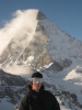
Early morning in Avy Gulch:
Climbers nearing the summit from the top of Misery Hill:
Skinning over to the W face:
Skiing the W face:
W face:
Early morning on the Hotlum Wintun:
-
06-10-2016, 02:19 PM #398
Registered User
- Join Date
- Mar 2011
- Location
- Tahoe
- Posts
- 1,175
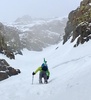
Booting higher up:
Near the top:
Skiing:
I think that's it for my ski season. It's time to climb & bike. It was a nice end to the season up there.
-
06-10-2016, 04:30 PM #399
Don't Panic
- Join Date
- Jun 2006
- Location
- Ventura Highway in the Sunshine
- Posts
- 22,445
Nice set of pics. Your last day looks like the best. Three days in a row like that would have killed me. Well played.
I agree it is a constitutional right for Americans to be assholes...its just too bad that so many take the opportunity...iscariot
-
06-10-2016, 09:30 PM #400
Registered User
- Join Date
- Jun 2016
- Posts
- 5
Hey Guys, Originally Posted by jorion
Long time reader, first time poster! I'm planning on heading up to Lassen as well this weekend and game to shuttle on Sunday. Here are a few pics from my last trip over Memorial Day Weekend:
View from Devastated Area Parking Lot

 Reply With Quote
Bookmarks