
There's pretty good free satellite pictures available these days. The Sentinel satellites revisit every few days. In these images you can almost see a trail, and definitely trace a road. For example I was checking out Highland Lakes access, and can see the hwy 4 is plowed almost to Pacific Grade Summit. Desolation's individual lakes can be seen.Originally Posted by Thesystemsplit

There's also some NASA satellites that revisit twice daily, aqua and terra, and I think they have a few friends now too, but the resolution is much lower, similar to the continuously updated GOES satellites. These images are only good enough for tracing drainages. I'd only use it if the most recent Sentinel images are too cloudy.
Sentinel satellite showing part of Desolation Apr 30
eta: You might also watch some snow sensors to see how fast it's melting at similar elevations near your route. water.ca.gov. Some sensors update hourly. You'll have to puzzle that site out yourself, they've changed it. I've noticed that in sunny clear weather, 3-4 inches melt per day. So if you're looking two weeks before a trip, 3-4 feet can turn into nothing.
I may be up for some Highland Peak antics once the road opens...
Results 2,376 to 2,400 of 2904
-
05-03-2024, 10:56 AM #2376
 click here
- Join Date
- Oct 2008
- Location
- valley of the heart's delight
- Posts
- 2,602
10/01/2012 Site was upgraded to 300 baud.
-
05-03-2024, 01:45 PM #2377
 Registered User
- Join Date
- Sep 2014
- Location
- Mogul, NV
- Posts
- 165
Yeah, Im using nwcc to see the rubicon and echo snow sites(they're losing around 1-3" a day right now, but this w/e storm will bring some of that back) and I'm also on sentinel as well, but thank you for the advice, much appreciated! Fingers crossed that after this storm it warms up a bit more than is currently projected. Originally Posted by LongShortLong
On another note this Sunday is looking like a good day to get out on the skis again .. which is hard to complain about.
Sent from my iPhone using TGR Forums
-
05-03-2024, 07:08 PM #2378

 can fly!
- Join Date
- Jan 2004
- Posts
- 18,836
ok so
this just keeps getting better
I’m going to be working full time at The Backcountry
that’s how all this shit started for me 30 years ago
I moved to Truckee and worked at The Sierra Mountaineer for a few years, and then Alpenglow
full fkn circleI didn't believe in reincarnation when I was your age either.
-
05-04-2024, 06:58 AM #2379
 terminal intermediate

- Join Date
- Oct 2008
- Location
- Wenatchee
- Posts
- 15,874
Are you in Sonora now? Originally Posted by ~mikey b
Sent from my iPhone using TGR Forums
-
05-04-2024, 07:50 AM #2380
can fly!
- Join Date
- Jan 2004
- Posts
- 18,836
at the moment yes
bouncing back and forth movingI didn't believe in reincarnation when I was your age either.
-
05-04-2024, 07:58 AM #2381
terminal intermediate
- Join Date
- Oct 2008
- Location
- Wenatchee
- Posts
- 15,874
Good for you, good luck with the move
Sent from my iPhone using TGR Forums
-
05-04-2024, 08:32 AM #2382
can fly!
- Join Date
- Jan 2004
- Posts
- 18,836
fkna
I didn't believe in reincarnation when I was your age either.
-
05-04-2024, 11:46 AM #2383
 Deepo days
- Join Date
- Jun 2007
- Location
- Cruzing
- Posts
- 12,174
Mostly on my Wildcat 108. Of the morning is quite cold and it will be firm through late morning to early afternoon , I'm on my Wren 98 (or are they 96?). Originally Posted by forumskier
I find the rocker profile of the Wildcats keep the base off the snow when running flat, although the Wrens are for sure faster in the flat/sticky later afternoon stuff. OTOH, Wildcats perform better in steep slush.
I will also sometime take out old old fully cambered Mantras.
Sent from my iPhone using Tapatalk
-
05-04-2024, 11:59 AM #2384
 Old Man and the Ski
- Join Date
- Apr 2007
- Location
- Tahoe
- Posts
- 16,326
Liberty must have sent home all their extra winter contract workers. There’s been a line down across 89 in Meeks bay for 2 hours now and still just the fire crew on scene and no estimate of when they’ll show up despite the road closure
Sent from my iPhone using TGR Forumspowdork.com - new and improved, with 20% more dork.
-
05-04-2024, 12:56 PM #2385
 far from my next whomp
- Join Date
- Aug 2006
- Posts
- 9,771
Tahoe '23/'24 - Reserve Now For Best Pricing!!!
It’s fucking howling and dumping in the foothills! Should be fun at dsr tomorrow
-
05-04-2024, 01:38 PM #2386
can fly!
- Join Date
- Jan 2004
- Posts
- 18,836
should be an entertaining drive this afternoon/evening
I didn't believe in reincarnation when I was your age either.
-
05-04-2024, 02:30 PM #2387
 Registered User
- Join Date
- Jan 2008
- Location
- truckee
- Posts
- 24,901
An old friend of ours with a lot of experience in the outdoors in California--worked on top of the towers building the GG Bridge, then commercial fishing--said there's always a storm in May. In my much briefer experience of only 48 years in CA I cannot remember a May when there wasn't. (That doesn't mean there hasn't been, only that I can't remember.) It may not snow in December or January but it always snows in May.
-
05-04-2024, 02:55 PM #2388
Registered User
- Join Date
- Apr 2006
- Location
- SF & the Ho
- Posts
- 11,077
I’ve had a number of epic pow days in Tahoe in May. The major snow in 2011 had several days of freshies at the end of May. Definitely not remotely unusual to have a good snow storm this time of year
-
05-04-2024, 02:56 PM #2389
Registered User
- Join Date
- Apr 2006
- Location
- SF & the Ho
- Posts
- 11,077
That’s awesome. Congrats. Let us know when you start so we can pop in Originally Posted by ~mikey b
-
05-04-2024, 10:02 PM #2390
 backseat w/ the cool kids
- Join Date
- Dec 2011
- Location
- sutro tower
- Posts
- 665
thank god photo upload is fixed all i wanted to do was put up this pic
-
05-04-2024, 11:29 PM #2391
Old Man and the Ski
- Join Date
- Apr 2007
- Location
- Tahoe
- Posts
- 16,326
Definitely one of my favorite months of skiing Originally Posted by mcski
Last edited by powdork; 05-04-2024 at 11:51 PM.
powdork.com - new and improved, with 20% more dork.
-
05-05-2024, 02:12 AM #2392
Old Man and the Ski
- Join Date
- Apr 2007
- Location
- Tahoe
- Posts
- 16,326
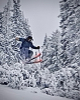
If you've been paying attention this storm wasn't a sleeper. Heard great tales from OV today. After making it to the south shore I got back in time to make it into work a bit early, and then invoke the pawder clause once we opened and staff was there.
wooojoooo for image upload
12"+ at 7K and kept dumping. Tomorrow is gonna be off the hook early
powdork.com - new and improved, with 20% more dork.
-
05-05-2024, 09:01 AM #2393
Deepo days
- Join Date
- Jun 2007
- Location
- Cruzing
- Posts
- 12,174
26" reported at OV. Wow. Have fun out there. I hade a birthday party and sleepover to manage last night. So watching soccer this morning is my reward.
Sent from my iPhone using Tapatalk
-
05-05-2024, 09:25 AM #2394
Registered User
- Join Date
- Nov 2008
- Posts
- 10,697
Ha!! Originally Posted by emcee
Backstory?
-
05-05-2024, 10:53 AM #2395
 swineherd
- Join Date
- Feb 2010
- Posts
- 1,740
Originally Posted by emcee
Doughnuts in the meadow? Originally Posted by PB
P.S. That pic is poster worthy!
Last edited by fomofo; 05-05-2024 at 11:18 AM.
The past is a foreign country; they do things differently there.
-
05-05-2024, 11:00 AM #2396
 Registered User
- Join Date
- Apr 2024
- Posts
- 299
Have fun out there! I'm jealous. I'm screwed, I blew out my back, I have a big coding project/report due tonight, and a GD&T exam tomorrow. Triple whammy.
-
05-05-2024, 11:06 AM #2397
Registered User
- Join Date
- Apr 2006
- Location
- SF & the Ho
- Posts
- 11,077
That KT line looked like it might have set a record lol Originally Posted by Ottime
-
05-05-2024, 03:38 PM #2398
far from my next whomp
- Join Date
- Aug 2006
- Posts
- 9,771
Never been to dsr. That was fun.
-
05-05-2024, 04:51 PM #2399
can fly!
- Join Date
- Jan 2004
- Posts
- 18,836
Squaw was a bit much today
I had some issues with my Shifts so I ended up bailing early rather than grabbing another pair of skis
when I left at 1 the traffic coming in was still backed up coming in
snow was deep and good
not my scene, though, that’s for sureI didn't believe in reincarnation when I was your age either.
-
05-05-2024, 04:55 PM #2400
backseat w/ the cool kids
- Join Date
- Dec 2011
- Location
- sutro tower
- Posts
- 665
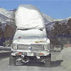
i was coming back from a nice tour off stevens peak and saw a car spunoff in audi corner, when i saw it was a cybertruck i had to grab a pic, i wasnt the only one stopping and laughing.
the owner had a camera slung over his shoulder so i do think he intentionally pulled it in there to take pics, but it was clearly stuck at this point and CHP was rolling their eyes
some stoke from the day

 Reply With Quote

Bookmarks