
Climbed the N ridge and skied the NW face of Adams on 6/11 with my buddy and TGR lurker backwards_banana. One hell of an adventure! The terrain is so much different than the more traveled S side of Adams. We hiked in and setup camp around 6400 feet on Monday evening, then climbed and skied the following morning. The climb up the N ridge was a beast. Lots of loose rock, big exposure, and booting for hours (the two times we made navigation errors and had to backtrack didn't help). We started skiing at 230 (yeah, sounds super late), but that was actually perfect timing for good snow conditions down the face.
View of the N side. Our ascent route is along the N ridge (aka The Cleaver) in blue, and our descent is on the NW face in green. The Adams Glacier is in the middle - it is a monster.
Closer look at our descent route.
Hiking in - the first view of Adams after maybe 45 mins or an hour of walking?
Yup, this is a good place to setup camp. Took 2-2.5 hours to get here. Great view of Rainier.
View from camp. Rainier on the left, Goat Rocks on the right. Looks like there is a lot of fun to be had in the Goat Rocks still...
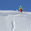
The next morning, ready to go. We skinned up the bowl to start, and finished the day with fun turns back down.
On top of the bowl above camp. Our first real view of the line on photo left.
Now the fun begins... about 1.5-2 hours to the base of the N ridge. It involved a lot of this:
And this:
And this:
Starting out the N ridge climb and the damn goats are already getting in our way:
One of many tricky spots to navigate on the ridge:
We decided to go climber's left of the ridge here and had to backtrack out. Should have gone right... The E facing Lava Headwall is on photo left - looks like a great ski if you can time it right. There were two large loose wets that ran down the face while we were working our way up.
Getting back on course:
6ish hours later, finally at the top of the N ridge. More awesome views of Rainier and Goat Rocks.
From the top of the N ridge, it is a long skin across the top of Adams Glacier to the Pinnacle and the top of our ski line (the pointy feature photo right). For some perspective, I'm that black dot in the center of the plateau above the glacier.
The ski line doesn't start off very steep, but there are several blind rollers and it gets progressively steeper as you work your way down the face. We regrouped every 500 ft or so and leap-frogged down the face.
View from the top of the line:
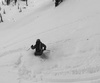
Skiing the first pitch:
OK, its getting steeper now...
Navigating the face was tricky and took a lot of discussion each time we regrouped. So glad we each had GPS and waypoints plotted on the map.
View of Mt St Helens from a regroup point:
It took a while to find our planned exit - a cluster of small chutes, and a traverse right after the chutes to enter the glacier.
Don't go any lower... nothing fun down there. Time to traverse.
This crack onto the glacier was bigger than expected, but still just a small hop. Just ski straight over it with some speed.
We stopped under this serac to discuss options for navigating out of the glacier. It was stupid of us to stop here in hindsight- right after I took this photo and as we were agreeing on an exit, large chunks broke off and we hauled ass out of there.
The cracks on the Adams Glacier, even down low, are massive and much larger than I expected.
Existing the line. Great views from below.
We still had another 1500-2k ft of mellow skiing across the flats of the glacier. Thanks to the climbers who gave us footprints to follow.
Refilling water at a melt pool before the last push back to camp.
Last turns back to camp - close to 4PM and still fun skiing.

Results 1 to 25 of 27
-
06-12-2019, 12:05 PM #1
 Registered User
- Join Date
- Aug 2016
- Location
- No longer Alexandria, VA
- Posts
- 2,681
Mt Adams - N ridge climb, NW face ski
-
06-12-2019, 12:10 PM #2
 No I'm not an Australian
- Join Date
- Dec 2003
- Location
- Seattle
- Posts
- 33,935
Solid work. And great photos. Thanks for sharing.
 Originally Posted by Downbound Train

-
06-12-2019, 12:39 PM #3
 Cat. Tastes like chicken
- Join Date
- Aug 2007
- Location
- Bottom feeding
- Posts
- 11,762
Nice TR.
Well maybe I'm the faggot America
I'm not a part of a redneck agenda
-
06-12-2019, 12:43 PM #4
 registered peruser
- Join Date
- May 2009
- Location
- inpdx
- Posts
- 21,205
Nice, thanks for posting this up...it looks like an adventure!
You do this one with Clay?
-
06-12-2019, 12:45 PM #5
Registered User
- Join Date
- Aug 2016
- Location
- No longer Alexandria, VA
- Posts
- 2,681
Alec, not sure if you've met him. Clay left the area for what he would say are greener pastures in Montana. Originally Posted by acinpdx
-
06-12-2019, 01:12 PM #6
 snowboardeur
- Join Date
- Jun 2014
- Location
- Montreal, Canada
- Posts
- 1,935
Sweet TR, "Navigating the face was tricky and took a lot of discussion each time we regrouped. So glad we each had GPS and waypoints plotted on the map. " No doubt! Looks you could easily lose your line if not careful...
27° 18°
-
06-12-2019, 01:21 PM #7
Registered User
- Join Date
- Mar 2008
- Location
- Boulder
- Posts
- 331
Excellent. Did it seem like there was enough snow to hold up for a while?
-
06-12-2019, 01:31 PM #8
Registered User
- Join Date
- Aug 2016
- Location
- No longer Alexandria, VA
- Posts
- 2,681
I think the N ridge climb is out or very close to it, especially with the warmup this week. The E side of the ridge was wet and sloppy by 8AM. Loud running water under the snowpack in a lot of places on the other side of the ridge. Super loose and sketchy rock where there isn't snow. Originally Posted by trogdortheburninator
The snow on the NW face will probably hold up for a while. The snow surface was smooth with no signs of runnels and minimal suncups. If you're going to ski it, I would recommend another route up (maybe up via the standard S side climbing route?). Not sure if that is a good idea though - I felt it was pretty key to scope out our descent while climbing up.
If you decide to go and need more info, PM me and I can share GPX files with you or give more details.
-
06-12-2019, 01:33 PM #9
Registered User
- Join Date
- Nov 2015
- Posts
- 5,378
Wow, looks like a great time and weather on your side. Nice!
-
06-12-2019, 06:42 PM #10
Registered User
- Join Date
- Sep 2018
- Posts
- 2,735
You're a glutton for punishment
Sent from my H3223 using Tapatalk
-
06-12-2019, 08:44 PM #11
Registered User
- Join Date
- Aug 2016
- Location
- No longer Alexandria, VA
- Posts
- 2,681
Only if there’s a beer at the end Originally Posted by SirVicSmasher
-
06-12-2019, 08:56 PM #12
 Registered User
- Join Date
- Feb 2015
- Location
- MA
- Posts
- 4,705
Inspiring stuff, T
-
06-13-2019, 09:31 AM #13
 Average on a good day
- Join Date
- Sep 2010
- Location
- Central OR
- Posts
- 1,157
Adding NFNWR to help me and others search later [emoji7]. Awesome TR.
-
06-13-2019, 01:41 PM #14
 Registered User
- Join Date
- Apr 2016
- Location
- roaming into the gloaming
- Posts
- 668
One of the best lines around, except for that sketchy N ridge slog. Thanks for taking the time to document it and share it.
-
06-13-2019, 02:00 PM #15
Registered User
- Join Date
- Sep 2005
- Location
- Fresh Lake City
- Posts
- 4,765
sweet line thefortress! Definitely a fun ski and a steep line, I actually prefer it and lava ridge to the SW chutes. As someone else pointed out, its called the North Face of the Northwest Ridge or NFNWR.
I never really found the north ridge route to be sketchy. Every time I've went up the north ridge, I used tennis shoes as its typically fairly dry. You can also use the NW ridge or Adams Glacier to approach the NFNWR. Originally Posted by river59
-
06-13-2019, 03:02 PM #16
Registered User
- Join Date
- Aug 2016
- Location
- No longer Alexandria, VA
- Posts
- 2,681
Interesting thought. I feel like Adams Glacier would be a questionable approach right now with the crazy amounts of overhead hazard and open cracks. Maybe earlier in the season? We crossed paths with two climbers trying to get up the Adams Glacier and they decided to turn around at 9k because of those problems. Originally Posted by BRUTAH
NW ridge seems another way to approach, potentially more mileage than the N ridge? I didn't get a look over there to see what the terrain is like - that would be climbing up the Pinnacle Glacier, yeah?
-
06-13-2019, 03:09 PM #17
Registered User
- Join Date
- Apr 2016
- Location
- roaming into the gloaming
- Posts
- 668
You are right, there isn't anything particularly sketchy about the ridge. I just always find myself stumbling and bumbling around on that ridge while rock hopping in ski boots. I feel like a dope for not having done it in sneakers...but I will next time! Originally Posted by BRUTAH
-
06-13-2019, 03:34 PM #18
Registered User
- Join Date
- Sep 2005
- Location
- Fresh Lake City
- Posts
- 4,765
I don't think going up Adams Glacier is ideal. Its definitely one of the more technical ascents on the mountain. Just another option.
I don't believe the NW ridge puts you on the pinnacle glacier but i could be wrong. It does hold snow better than the north ridge and is a cruisier ascent, 30 degrees till the top when it hits 40. It is a little longer than the north ridge since you start closer to the north ridge. Not sure the mileage differences, never seemed like that much further and it deposits you on top of the NFNWR if thats your intended descent.
-
06-16-2019, 02:50 AM #19
Mike Pow
- Join Date
- Apr 2005
- Location
- Between a rock and a soft place. Aberdare and The Brecon Beacons, Wales
- Posts
- 3,306
Fantastic.
-
06-16-2019, 06:52 AM #20

 Registered User
- Join Date
- Apr 2009
- Location
- Sedrun CH
- Posts
- 492
Chapeaux!!!!
-
06-16-2019, 09:48 AM #21
registered abuser
- Join Date
- Oct 2003
- Location
- tahoe
- Posts
- 3,428
fuk ya!!!++++++
-
06-16-2019, 11:48 AM #22
 I ski cementometers.
- Join Date
- Sep 2014
- Posts
- 1,913
Beauty!
Master of mediocrity.
-
06-17-2019, 05:57 PM #23
 Registered User
- Join Date
- Dec 2010
- Location
- Last Best City in the Last Best Place
- Posts
- 8,195
Looks awesome, nice job.
-
06-18-2019, 06:42 PM #24
 Registered User
- Join Date
- Mar 2004
- Location
- Maine
- Posts
- 827
Awesome trip, pics & report.......
-
06-24-2019, 11:46 AM #25
Banned
- Join Date
- Sep 2017
- Posts
- 725
Did you bring a gun?
https://www.tetongravity.com/forums/...Mount-Adams-NH)

 Reply With Quote
Bookmarks