
Hey all,
I want to share a new site that I've been working on: https://avyeyes.com
The idea is to allow anyone to quickly create and share avalanche reports in 3D. It's kind of like looking at an avalanche in Google Earth, but completely within the web browser and linkable/shareable from anywhere on the web. User's can zoom, tilt, rotate, and pan the 3D map to view avalanches from any angle. Clicking on the red avalanche path brings up the report with associated data fields, comments, and images submitted by the reporter.
Here are a handful of avalanches from Colorado (and some screenshots below showing the slides from different angles in AvyEyes):
05-24-2015 Red Peak, Gore Range: https://avyeyes.com/ktqfgc3h
05-11-2013 Mt. Ouray, Devil's Armchair: https://avyeyes.com/6o91ro60
11-21-2015 Berthoud Pass, 90s: https://avyeyes.com/1vc0mfao
05-11-2008 Coon Hill, SE Face: https://avyeyes.com/vsik4e4n
Each avalanche report is given a unique, randomly-generated 8-character ID and navigating to https://avyeyes.com/<8-char-id> will fly you directly to that avalanche. Each avalanche report also has Tweet/Share buttons that will post the unique report link to Twitter or Facebook.
You can also go to https://avyeyes.com (sans 8-char id), fly the view to a specific location of interest, and search for avalanches that have been submitted in that area. (although there aren’t many avalanches in the database yet... hopefully that'll change soon
The site is free, open to all, and can be used to display avalanches anywhere in the world.
I’m rolling out avyeyes.com and want to invite everyone to use it anytime you want to share/communicate an avalanche! Submitting a report is a simple two step process: 1) draw the avalanche path on the 3D map with the mouse, and 2) enter the avalanche details/images. That’s it. You can add as much or as little detail as you want.
Hit me up with any questions, comments, or ideas for improvement. Or email avyeyes@gmail.com

Results 1 to 17 of 17
Thread: avyeyes.com
-
01-25-2016, 08:00 PM #1

 Registered User
- Join Date
- Sep 2004
- Location
- Golden, CO
- Posts
- 443
avyeyes.com
-
01-25-2016, 08:06 PM #2
 ~~~(oYo)~~~
- Join Date
- Feb 2005
- Posts
- 19,777
When I click on those links I just get the logo and the spinning. Waterfox 43.0.4.
Is it radix panax notoginseng? - splat
This is like hanging yourself but the rope breaks. - DTM
Dude Listen to mtm. He's a marriage counselor at burning man. - subtle plague
-
01-25-2016, 08:10 PM #3
 Registered User
- Join Date
- Dec 2004
- Location
- Where the sheets have no stains
- Posts
- 24,133
Pretty cool if enough people use it. The avalanche links work fine on my system. The homepage doesn't load.
Is there any plan for filters to screen out the umm kooks?I have been in this State for 30 years and I am willing to admit that I am part of the problem.
"Happiest years of my life were earning < $8.00 and hour, collecting unemployment every spring and fall, no car, no debt and no responsibilities. 1984-1990 Park City UT"
-
01-25-2016, 08:20 PM #4
Registered User
- Join Date
- Sep 2004
- Location
- Golden, CO
- Posts
- 443
There's a lot of javascript that's downloaded initially, so depending on connection speed, network traffic, etc sometimes it times out and gives up if it can't get all the js downloaded in a reasonable amount of time. Eventually it comes up though. You might need to try the URL a few times. Originally Posted by MakersTeleMark

...I might need to look into a more aggressive caching/CDN strategy eventually.
-
01-25-2016, 08:27 PM #5
Registered User
- Join Date
- Sep 2004
- Location
- Golden, CO
- Posts
- 443
Short answer: no filters. Originally Posted by Bunion
Longer answer: Reports are given a basic review and then approved. The review is just to weed out any blatant stupidity or intentional asshattery. Submitter's also self-rank their experience level, so you have a general idea of the knowledge level of the submitter.
-
01-25-2016, 08:42 PM #6
~~~(oYo)~~~
- Join Date
- Feb 2005
- Posts
- 19,777
Loads in 3 seconds with Edge. Will not load in WF. Originally Posted by GFP
Is it radix panax notoginseng? - splat
This is like hanging yourself but the rope breaks. - DTM
Dude Listen to mtm. He's a marriage counselor at burning man. - subtle plague
-
01-29-2016, 03:17 PM #7
 heartcore
- Join Date
- Jan 2006
- Location
- Vanity Fair
- Posts
- 2,724
not loading on chrome. sounds interesting though.
Ich bitte dich nur, weck mich nicht.
-
01-29-2016, 04:36 PM #8
 ahhhh!
- Join Date
- Jan 2008
- Location
- livin the dream
- Posts
- 6,400
Very cool tool. Well done.
Best Skier on the Mountain
Self-Certified
1992 - 2012
Squaw Valley, USA
-
01-29-2016, 05:01 PM #9
 No I'm not an Australian
- Join Date
- Dec 2003
- Location
- Seattle
- Posts
- 33,935
OP have you seen this yet....www.avatech.com
Originally Posted by Downbound Train
-
01-29-2016, 07:58 PM #10
Registered User
- Join Date
- Sep 2004
- Location
- Golden, CO
- Posts
- 443
I've just recently (today) made some improvements to site loading performance. Namely implementing caching and compression. You might want to try again. Things should be getting faster. At least https://gtmetrix.com tells me it's getting faster Originally Posted by klar

-
01-29-2016, 07:59 PM #11
Registered User
- Join Date
- Sep 2004
- Location
- Golden, CO
- Posts
- 443
Yep. Same same but different. Originally Posted by PNWbrit
-
01-31-2016, 01:14 AM #12
heartcore
- Join Date
- Jan 2006
- Location
- Vanity Fair
- Posts
- 2,724
Loading now. How would I find avalanches if i don't already know where they are? I guess it wont search if you are not zoomed in under 10 km?
Ich bitte dich nur, weck mich nicht.
-
01-31-2016, 08:45 PM #13
Registered User
- Join Date
- Sep 2004
- Location
- Golden, CO
- Posts
- 443
There are two ways to find avalanches:
- Someone submits an avalanche and shares the https://avyeyes.com/<unique-id> URL with you (via email, forum post, facebook, twitter, text, whatever), or...
- You fly the view to a specific area of interest (maybe a usual ski spot, or maybe a new area that you are thinking about checking out) and search.
In the second case, you begin with an area that you're interested in. The geographic bounds of the map view are essentially the first piece of search criteria. Only avalanches that occurred within the bounds of the map view will be returned. And you are correct that the view needs to be zoomed in to no greater than 10km above the ground when searching.
-
01-31-2016, 10:50 PM #14
 *NOT* an expert
- Join Date
- Oct 2003
- Location
- 9,300ft
- Posts
- 23,136
Neat...
check SWAG though
R scale doesn't do halves
Needs the intentional unintentional modifiers for Trigger
Need the interface/failure designation (eg O for in the old snow) Originally Posted by blurred
-
02-01-2016, 08:11 AM #15
Registered User
- Join Date
- Sep 2004
- Location
- Golden, CO
- Posts
- 443
Thanks, that's great feedback!
I'll change the R-scale to be whole numbers only. <--- That's done. Clear your browser cache and refresh to see the change
The omission of the cause modifiers for natural/human triggered slides was *cough* intentional. I wasn't sure if they added much value for most people. However, as you note, they are part of SWAG and should probably be included. I think I may go back and add them.
^^^ That's done too. The report now includes a field for the trigger modifier (r,y,c,u).
I do capture the interface/failure designation for avalanche reports (see attached screenshot). It's just not a search criteria field on the homepage.
Last edited by GFP; 02-15-2016 at 10:37 PM.
-
02-02-2016, 10:07 AM #16
heartcore
- Join Date
- Jan 2006
- Location
- Vanity Fair
- Posts
- 2,724
Okay, thanks. Personally I like being able to have a large scale overview of where incidents occurred, like so: Originally Posted by GFP
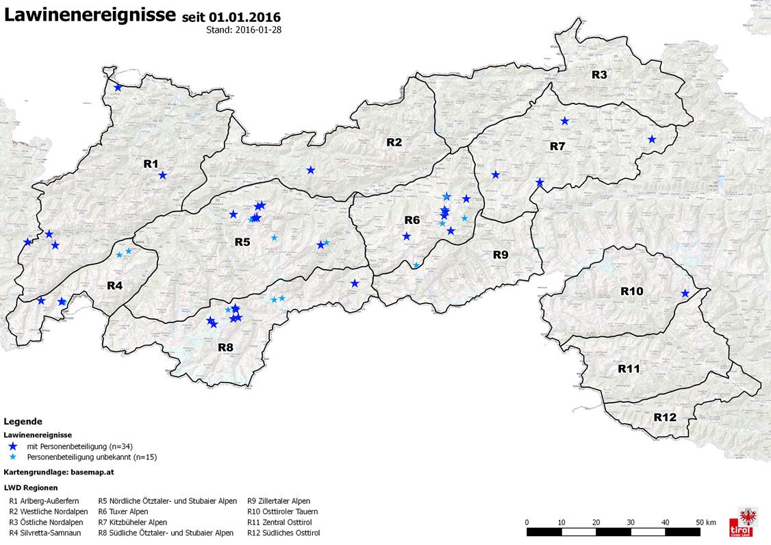
Knowing this area, that tells me that certain zones are problematic, while others are less so. In this case almost all incidents are above treeline in drier, more central regions, where there is a persistent weak layer.Ich bitte dich nur, weck mich nicht.
-
02-04-2016, 12:45 PM #17
Registered User
- Join Date
- Sep 2004
- Location
- Golden, CO
- Posts
- 443
Yeah, I see your point. The problem is that zooming out that far reduces the avalanche paths to little red zits on the map (or makes them impossible to see at all). AvyEyes is about visualizing the avalanche path, and to do that you need to be zoomed in to an altitude which allows the path to be visible.
It would be like using Zillow to visualize houses/lots but then zooming out to such a high level that the houses and lots are no longer visible. Although, like Zillow, I could progressively replace the avalanche paths with pins (or some other graphic) if the eye alt is above a certain level, then replace the pins with the path drawings once the view is zoomed in to that threshold level. I think that idea has merit. I'll make a note of it and maybe include it in a future release.

 Reply With Quote
Bookmarks