
Results 1 to 25 of 26
-
11-03-2013, 08:57 AM #1

 Registered User
- Join Date
- Mar 2008
- Location
- Da Norf Lake
- Posts
- 2,502
Video Games for Avy Nerds -Educational too!
Even sometimes when I'm snowboarding I'm like "Hey I'm snowboarding! Because I suck dick, I'm snowboarding!" --Dan Savage
-
11-03-2013, 09:44 AM #2
Banned
- Join Date
- Dec 2009
- Posts
- 7,167
awesome! fun game! one of the best learning tools I've seen yet fer sure
thanx for sharing!
rog
-
11-04-2013, 12:01 AM #3
 Registered User
- Join Date
- Nov 2006
- Location
- utar
- Posts
- 2,741
pretty cool
 Originally Posted by SpinalTap

-
11-04-2013, 02:56 AM #4
 broken shell of a man
- Join Date
- Apr 2013
- Location
- PNW
- Posts
- 201
I believe I can fly
-
11-04-2013, 06:38 PM #5
Registered User
- Join Date
- Jan 2010
- Location
- mcflattown
- Posts
- 724
Canadian avalanche centre also did one last fall. Routefinding is hudge.
http://www.avalanche.ca/cac/training...ding-exercises
-
11-04-2013, 06:44 PM #6
Banned
- Join Date
- Dec 2009
- Posts
- 7,167
makes any and every day no matter what the days rating are an opportunity for a good look around. Originally Posted by theshredder
rog
-
11-15-2013, 10:23 AM #7
 ____________________
- Join Date
- Sep 2008
- Location
- Not Brooklyn
- Posts
- 8,495
Great idea. Those are excellent.
-
12-06-2013, 12:10 AM #8
 Bearded Sweater Model
- Join Date
- Oct 2004
- Location
- 50 miles E of Paradise
- Posts
- 16,938
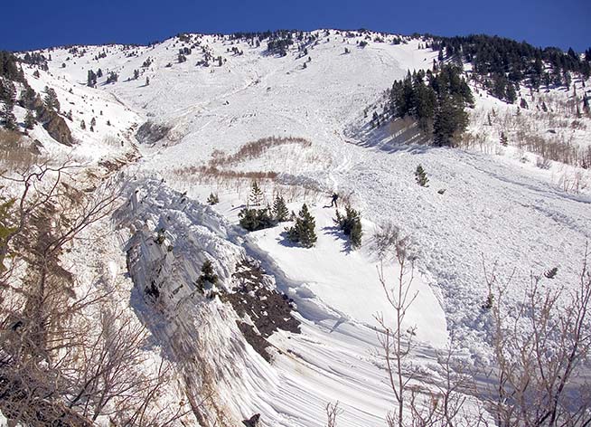
Cool stuff. On all but the first route, my thought was "I'm not all that confident you can get theya from hea. I'll just stay at the hut and drink coffee." Even the routes that worked had a couple of sections where my butt puckered.
ETA - Toughest part about these routes to me = everything's way above tree line, so there's no safe zones to hide in.
Anybody know of stats on people getting caught on the ascent vs the down?Last edited by TBS; 12-06-2013 at 12:21 AM.
-
12-06-2013, 05:57 AM #9
Banned
- Join Date
- Dec 2009
- Posts
- 7,167
what you see on the screen is a bit different than what you'd see if you were standing right up in it. it ain't perfect, but a great exercise for terrain and micro terrain management. Originally Posted by telebobski
plenty of safe zones above treeline. look to lower (less than 30) angle terrain with nothing steeper directly above you or attached to it that would cause you to become exposed to terrain traps and steeper convexities if you were to pass through.ETA - Toughest part about these routes to me = everything's way above tree line, so there's no safe zones to hide in.
climb what you ski!Anybody know of stats on people getting caught on the ascent vs the down?
rog
-
12-06-2013, 06:53 AM #10
Registered User
- Join Date
- Dec 2004
- Posts
- 493
Yup Originally Posted by icelanticskier
Got bored in about a minute of play.
-
12-06-2013, 09:38 PM #11
Bearded Sweater Model
- Join Date
- Oct 2004
- Location
- 50 miles E of Paradise
- Posts
- 16,938
Really? You mean terrain looks different IRL than in a photo? Wow, what an epiphany! Originally Posted by icelanticskier
No shit Sherlock. Point is that every one of the NZ examples (except the first) had at least one point on the route requiring travel through a sketchy zone - over 30 degrees, some trapping, low sun aspects, rollovers, ugly consequences - that's what made me wonder whether the risks would be worth the rewards. The CAA examples also had pucker points, they just had more treed zones so easy for me to relate. Originally Posted by icelanticskier
I was asking if anyone knew of stats for the proportion of people caught in slides while ascending vs descending. Thanks for the Chauncey Gardiner response... Originally Posted by icelanticskier
-
12-06-2013, 09:48 PM #12
Banned
- Join Date
- Dec 2009
- Posts
- 7,167
well I guess you got it all figured out telebutthurtski.:rollseyes:
rog
-
12-07-2013, 08:52 AM #13
Bearded Sweater Model
- Join Date
- Oct 2004
- Location
- 50 miles E of Paradise
- Posts
- 16,938
Nope, don't have it all figured out at all. Also not so fuckin arrogant to think I do.
But I gotta admit, you do bring the Lulz - maybe try waiting 72 hours before you post
-
12-07-2013, 09:34 AM #14
Banned
- Join Date
- Dec 2009
- Posts
- 7,167
^^^^^^^^^^this speaks volumes. Originally Posted by telebobski
how else should one respond to that?
rog
-
12-07-2013, 09:36 AM #15
Banned
- Join Date
- Dec 2009
- Posts
- 7,167
did you pull yer slope angle card out along the routes to be sure Originally Posted by telebobski
rog
-
12-07-2013, 10:46 AM #16
Bearded Sweater Model
- Join Date
- Oct 2004
- Location
- 50 miles E of Paradise
- Posts
- 16,938
How would you know anything about slopes >30 degrees. Ever been on one?
-
12-08-2013, 12:01 PM #17
Registered User
- Join Date
- Jan 2010
- Location
- mcflattown
- Posts
- 724
Dont know of any stats but I feel like a sitting duck with skins on. Your own momentum can really help you stay out of trouble. So I'd think there'd be more screw ups and more severe consequences for people on their way up. Originally Posted by telebobski
-
12-09-2013, 09:12 AM #18
____________________
- Join Date
- Sep 2008
- Location
- Not Brooklyn
- Posts
- 8,495
Isn't the challenge of the exercise to predict runout length/ alpha angle with limited information? While it is more difficult to accurately perceive depth in a photograph, I'd think practicing with virtual examples should make it easier to identify safe zones in the real world. Originally Posted by telebobski
I'd like to see the same exercise with topo maps as well.
-
12-09-2013, 10:46 AM #19
Bearded Sweater Model
- Join Date
- Oct 2004
- Location
- 50 miles E of Paradise
- Posts
- 16,938
^^^Absolutely, as well as mitigating risk.
It would have been cool to have topos along with the photos, if only to assess slope better. There were several places I was pretty sure would slide, but didn't.
-
12-09-2013, 10:53 AM #20
Banned
- Join Date
- Dec 2009
- Posts
- 7,167
maps/topos are great, but it's important to learn to read terrain and assess angles/terrain with the naked eye without having to rely on anything else.
go ahead telebutthurtski, lemme have it
rog
-
12-09-2013, 11:06 AM #21
 invested in pnw futures
- Join Date
- Jan 2011
- Location
- E >>> W
- Posts
- 3,653
Come on - that is straight up rogtarded
That might work on your home court in bluebird conditions, but would you go up on Hood / Rainier / Shasta with just your "instincts"? I agree that reading terrain and conditions on an instinctual level is important skill to develop, but it is a compliment to the basics.Climb the mountains and get their good tidings. Natures peace will flow into you as sunshine flows into trees. The winds will blow their own freshness into you, and the storms their energy, while cares will drop away from you like the leaves of Autumn. - John Muir
"How long can it last? For fuck sake this isn't heroin -
suck it up princess" - XXX on getting off mj
“This is infinity here,” he said. “It could be infinity. We don’t really don’t know. But it could be. It has to be something — but it could be infinity, right?” - Trump, on the vastness of space, man
-
12-09-2013, 11:29 AM #22
Bearded Sweater Model
- Join Date
- Oct 2004
- Location
- 50 miles E of Paradise
- Posts
- 16,938
Rog is the Chauncey Gardiner of avalanche science.
Go ahead Rog, tell us again how an isothermic snowpack has water in it! Fkin' brilliant!
-
12-09-2013, 02:48 PM #23
Banned
- Join Date
- Dec 2009
- Posts
- 7,167
put this in yer pipe and smoke it, JONG:
"Full spring conditions typically consist of an isothermal snowpack - One which is at 32 F throughout. The surface will refreeze overnight, and as it softens in the sun good "corn" snow makes great skiing. The hazard tends to follow a daily cycle of low in the morning and moderate in the afternoon. After softening too much wet slides can release, often starting as point releases and growing. A good rule of thumb is to head home when you start to sink to your boot tops.
Another hazard to keep in mind is that before softening up the snow can be icy and a fall can be dangerous. A few years ago a skier crossed into White Pine from Snowbird and tried to ski a long open slope a bit too early. A fall led to a long and fatal slide down the slope.
Large wet slides can be a hazard in the early spring, typically for a period of a few days when the snowpack first becomes isothermal. One reason for this is that free water can be introduced to snowpack too quickly if rapid warming occurs, especially if refreezing overnight does not occur. Initially this free water can flow along and lubricate buried bed surfaces, leading to wet slab releases. The effect of free water in the snowpack can be very difficult to predict. Ultimately, the free water and the melt-freeze process will hinder fracture propagation and break down the layering in the snowpack. After isothermal conditions prevail for a while the hazard of wet slabs becomes small"
not a facefuck message from Z.
rog
-
12-09-2013, 02:51 PM #24
Banned
- Join Date
- Dec 2009
- Posts
- 7,167
and no nopostbutthole, looking up at a mountain is looking up at a mountain. sure it helps to be intimately familiar, but even when I was 1st introduced to the Wasatch, it wasn't too hard to pick routes safely based on what my eyes saw.
rog
-
12-09-2013, 04:05 PM #25
 Obstinate Oldskooligan
- Join Date
- Jan 2006
- Location
- Alpental
- Posts
- 6,679
IMO, reading the terrain and conditions is the MOST important skill to develop and is fundamentally at the heart of the "basics". It's precisely the point of these route finding exercises- to develop the instincts of safe mountain travel that should be translatable to any slope regardless of familiarity. Topo maps are great for trip planning and general navigation, especially for travel over distances, but direct visualization always trumps the map for me when it comes to ascending and descending- where are the drainage/terrain traps, rollers, cliff outs, convex features, run out zones, etc. Originally Posted by NoPostholio
It's true that our instincts are most accurate best when combined with the greatest amount of additional information- current snowpack conditions, wind, weather, temps, etc. It would be cool if this info was able to be added to the pics in those exercises to present different travel scenarios through the same terrain, giving multiple routes based off of changing conditions within a particular setting.Move upside and let the man go through...

 Reply With Quote
Bookmarks