
indeed it is, congrats to Travis and Marc!
Results 1,626 to 1,650 of 3683
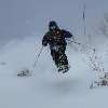
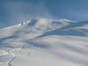
Thread: TR; this last weekend at Bridger
-
11-08-2009, 01:07 PM #1626

 ripping lips and lines

- Join Date
- Oct 2003
- Location
- bozone montuckey
- Posts
- 4,337
"They who can give up essential liberty to obtain a little temporary safety, deserve neither liberty nor safety."
Ben Franklin
-
11-08-2009, 02:01 PM #1627
 Registered User
- Join Date
- Sep 2009
- Location
- PNW -> MSO
- Posts
- 8,278
Yes, some nice words about BB in the December issue of Powder.
-
11-08-2009, 03:53 PM #1628
 Registered User
- Join Date
- Dec 2007
- Location
- northern gye
- Posts
- 528
 Originally Posted by workinforturns

Thank you to whomever sold their 188 bro's. You took damn nice care of them. Now I will love them to death.I think the potato gun proved the stability.
-
11-08-2009, 04:29 PM #1629
 Empty Your Mind
- Join Date
- Nov 2008
- Location
- The Chugach
- Posts
- 127
Fuck I miss Schlasmanssss and Bridger. im willnig to clean toilets all day if i can find a job and get back to bozo....anyone?

-
11-08-2009, 05:52 PM #1630
 Registered User
- Join Date
- Oct 2005
- Location
- Bozeangeles/Lonetree
- Posts
- 283
saw the pic with marc and travis last spring and it was an obvious money shot. Well done gentleman!!
-
11-08-2009, 06:06 PM #1631
Registered User
- Join Date
- Mar 2004
- Location
- alaska
- Posts
- 192
Good, go, its too crowded up here already Originally Posted by RambleOn

-
11-08-2009, 10:40 PM #1632
Empty Your Mind
- Join Date
- Nov 2008
- Location
- The Chugach
- Posts
- 127
hah.. well having a lift 15 minutes from town that drops you off on a backcountry ridge that you can shred all day does beat driving 45 mins to aly to wait in the chair 6 line-Cant blame me Originally Posted by Ak_pride
, although i cant wait to try out Alyeskas new tree runs.
-
11-09-2009, 06:29 AM #1633
Registered User
- Join Date
- Mar 2004
- Location
- alaska
- Posts
- 192
No, I hear you, I do miss the bozone sometimes,lived there for a couple years. can't beat the sunny powder days they always seem to get, although alyeska seemed to have an unusual number of them last season. Resort riding is definitely not the reason to move to ak though. Need to figure out how to get a sled this winter.
-
11-11-2009, 02:12 PM #1634
 Registered Boozer
- Join Date
- Oct 2007
- Location
- West Shore
- Posts
- 2,385
MTZ015-055-112200-
/O.NEW.KTFX.WS.W.0011.091112T0000Z-091113T0000Z/
/O.NEW.KTFX.WW.Y.0034.091112T0000Z-091113T0000Z/
MADISON-GALLATIN-
INCLUDING THE CITIES OF...ENNIS...TWIN BRIDGES...BOZEMAN...
WEST YELLOWSTONE
442 AM MST WED NOV 11 2009
...WINTER STORM WARNING IN EFFECT FROM 5 PM THIS AFTERNOON TO
5 PM MST THURSDAY FOR ELEVATIONS ABOVE 5000 FEET...
...WINTER WEATHER ADVISORY IN EFFECT FROM 5 PM THIS AFTERNOON TO
5 PM MST THURSDAY FOR ELEVATIONS BELOW 5000 FEET...
THE NATIONAL WEATHER SERVICE IN GREAT FALLS HAS ISSUED A WINTER
STORM WARNING FOR HEAVY SNOW...WHICH IS IN EFFECT
FROM 5 PM THIS AFTERNOON TO 5 PM MST THURSDAY.
A WINTER WEATHER ADVISORY HAS ALSO BEEN ISSUED. THIS WINTER
WEATHER ADVISORY IS IN EFFECT FROM 5 PM THIS AFTERNOON TO 5 PM MST
THURSDAY.
A MOIST PACIFIC STORM SYSTEM WILL COMBINE WITH A COOL CANADIAN
AIRMASS TO BRING SNOW ACROSS HIGHER ELEVATIONS OF SOUTHWEST
MONTANA STARTING LATE THIS EVENING THROUGH THURSDAY.
BELOW 5000 FEET PRECIPITATION WILL START OUT AS ALL RAIN OR A RAIN
AND SNOW MIX THIS AFTERNOON THEN CHANGEOVER TO ALL SNOW TONIGHT.
TOTAL SNOW ACCUMULATIONS WILL RANGE FROM 2 TO 6 INCHES BELOW 5000
FEET AND 6 TO 12 INCHES ABOVE 5000 FEET WITH LOCALLY HIGHER
AMOUNTS POSSIBLE. SNOW WILL TAPER TO SNOW SHOWERS THURSDAY
AFTERNOON.
woot
-
11-11-2009, 03:21 PM #1635
 Registered User
- Join Date
- Jan 2009
- Location
- Bozeman, MT
- Posts
- 183
^^^^^^^x2
woot woot!
-
11-12-2009, 12:31 AM #1636
 Fresh off the Griddle!
- Join Date
- Mar 2009
- Location
- ON YOUR PLATE
- Posts
- 324
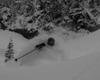
Fuck ya. Ha ha to everyone who isn't getting snow!!!

Behold my fluffy goodness, you bastard.
-
11-12-2009, 01:31 AM #1637
 The Fetamorphasis
- Join Date
- Nov 2007
- Location
- MT
- Posts
- 889
were the three guys i saw skinning up sac today maggots? how was it?
EDIT: I would just like to add that it is dumping in bozo.Last edited by OverTurn; 11-12-2009 at 02:57 AM.
-
11-12-2009, 09:29 AM #1638
 Registered User
- Join Date
- Dec 2008
- Location
- PDX
- Posts
- 5,321
Oh Yes. I just got face shots on my bike ride to school.
Be careful out there today kiddies! At least this stuff is coming in right side up.
-
11-12-2009, 09:47 AM #1639
 ...
...
- Join Date
- Dec 2002
- Posts
- 1,404
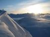
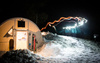
nov12snow
12-14" so far...

-
11-12-2009, 11:09 AM #1640
Registered User
- Join Date
- Jan 2006
- Location
- Missoula
- Posts
- 1,008
http://forecast.weather.gov/MapClick...ield2=-110.935
looks good for a couple days. ill be getting up tomorrow hopefully. ill be rocking those 201 dp pros i got at the swap! should be interesting.
-
11-12-2009, 11:43 AM #1641
 Registered User
- Join Date
- Oct 2006
- Location
- Idaho Falls, ID
- Posts
- 1,043
 holy shit
-
11-12-2009, 01:06 PM #1642
Registered Boozer
- Join Date
- Oct 2007
- Location
- West Shore
- Posts
- 2,385
make 'em say uhhhhhh.

-
11-12-2009, 01:34 PM #1643
 Waffle Haus Champion

- Join Date
- Oct 2006
- Location
- Maine
- Posts
- 1,418
if I have 15" at home in town, I wonder what bridger is looking like??
-
11-12-2009, 02:06 PM #1644
 dude brah epic pow gnar
- Join Date
- Mar 2008
- Location
- Bozeman
- Posts
- 342
Um... so yea, 18-24in ON TOP of the 12 in already in town... Welcome to the shit show of Bozeman driving.INCLUDING THE CITIES OF...ENNIS...TWIN BRIDGES...BOZEMAN...
WEST YELLOWSTONE
1018 AM MST THU NOV 12 2009
...WINTER STORM WARNING NOW IN EFFECT UNTIL MIDNIGHT MST
TONIGHT...
THE WINTER STORM WARNING FOR HEAVY SNOW IS NOW IN EFFECT UNTIL
MIDNIGHT MST TONIGHT.
MODERATE TO HEAVY SNOWFALL WILL CONTINUE ACROSS MUCH OF GALLATIN
AND MADISON COUNTIES INTO THE LATE EVENING HOURS. SNOWFALL RATES
AROUND ONE INCH PER HOUR CAN BE EXPECTED THROUGH 4 PM TODAY. BY
LATE THIS EVENING...EXPECT STORM TOTAL SNOWFALL AMOUNTS TO RANGE
FROM 18 TO 24 INCHES AT LOWER ELEVATIONS...INCLUDING THE CITIES OF
BOZEMAN AND ENNIS...TO AROUND 30 INCHES IN THE MOUNTAINS.
ADDITIONALLY...EXPECT VISIBILITIES TO BE REDUCED TO LESS THAN ONE
QUARTER OF A MILE AT TIMES.
AT 10 AM THIS MORNING...CURRENT SNOWFALL AMOUNTS RANGED FROM 10
INCHES IN ENNIS...TO OVER A FOOT IN THE CITY OF BOZEMAN...TO
AROUND 17 INCHES IN THE BEAR CANYON AREA.
BUT more importantly up to 30 inches in the mountains on top of the 12 that was there this morning...
[ame="http://www.youtube.com/watch?v=4pXfHLUlZf4"]YouTube- Jizz In My Pants[/ame]
-
11-12-2009, 02:26 PM #1645
Registered User
- Join Date
- Sep 2009
- Location
- PNW -> MSO
- Posts
- 8,278
Originally Posted by crazyskir05
Ha, I just witnessed a full-sized bus get stuck in front of my house, on the road.
The whole team of high school-aged girls had to unload into the snow while the driver made an ass of himself.
Bring it on, old man winter! Wrinkly old scrotum-head! Is this the best you can do?!
-
11-12-2009, 02:28 PM #1646
The Fetamorphasis
- Join Date
- Nov 2007
- Location
- MT
- Posts
- 889
FML I have to drive to Billings tomorrow for a dr. appt...
-
11-12-2009, 03:21 PM #1647
Waffle Haus Champion
- Join Date
- Oct 2006
- Location
- Maine
- Posts
- 1,418
so many people bad at driving trying to.
Some girl in her honda civic with bald tires tried pulling out of her driveway this morning while I was going to school and immediately got stuck. We helped push her car back in the the driveway and instructed her not to drive until May
-
11-12-2009, 03:21 PM #1648
Registered User
- Join Date
- Jan 2006
- Location
- Missoula
- Posts
- 1,008
^^you going to pick up your ice axe while you there for the rimrocks?

-
11-12-2009, 03:27 PM #1649
ripping lips and lines
- Join Date
- Oct 2003
- Location
- bozone montuckey
- Posts
- 4,337
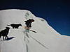
driving out kagy this morning had a young spike buck jump out in front of me. managed to keep it under control, miss the deer and keep the guy tailgating me from hitting me. that took some braking finesse.
then driving up rouse after lunch had a woman spin her f-250 sideways. she had both lanes covered and was sliding right at me. fortunately no one was parked on the street at that point and i was able to make use of the sidewalk to avoid her.
dont know how the skiing is today, but the driving is pretty damn exciting."They who can give up essential liberty to obtain a little temporary safety, deserve neither liberty nor safety."
Ben Franklin
-
11-12-2009, 04:45 PM #1650
 Registered User
- Join Date
- Sep 2006
- Location
- Bozeman
- Posts
- 720
Yo Jibba Jabba, Ima let you finish, but... Originally Posted by crazyskir05
Anyways. It says "STORM TOTAL"! before that. I know you're an engineer and all, but letterz and words mean shit, too. It would be sweet to get another 30" on top of what we have, but hey, it wouldn't be the first time the weather guys weren't spot-on.

 Reply With Quote
Similar Threads
-
TR: Baker didn't suck this weekend (pics/vid)
By bigtrubs in forum General Ski / Snowboard DiscussionReplies: 30Last Post: 03-15-2006, 05:08 PM -
President's Day Weekend -- MAMMOTH MOUNTAIN
By kingcorona13 in forum General Ski / Snowboard DiscussionReplies: 0Last Post: 02-22-2006, 11:43 AM -
A good, bad and ugly weekend
By crashnburn'd in forum Sprocket RocketsReplies: 6Last Post: 11-07-2005, 01:12 PM -
Any SLC mags want to hit Vegas this weekend?
By meatdrink9 in forum General Ski / Snowboard DiscussionReplies: 33Last Post: 10-25-2005, 11:53 AM -
New Yorkers :: eXXXXXtreme Freeriding This Weekend?
By jayfrizzo in forum Sprocket RocketsReplies: 22Last Post: 09-26-2005, 08:51 AM

Bookmarks