
Maybe not the gnarliest, but I want to see a TR on it.
Drive up trail creek road and get it done. I want to see lots of pics. thanks.
Results 1 to 18 of 18
-
05-08-2006, 09:59 PM #1

 is classy as fuck

- Join Date
- May 2004
- Location
- Colorado Cartel HQ
- Posts
- 15,931
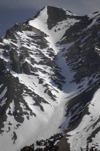
 Idaho maggot call out-Devils Bedstead
-
05-08-2006, 10:04 PM #2
 wooooooohoooooooooooooo
- Join Date
- Dec 2003
- Location
- funland
- Posts
- 5,255
how far from the Wyoming/Idaho border near Teton Pass?
-
05-08-2006, 10:29 PM #3

 Southbound Pachyderm
- Join Date
- Sep 2001
- Location
- Orangina
- Posts
- 9,653
We'll be up there. Not accessible yet, though. Me, jimmypage and a few others will hopefully give that area a run come late May/early June. Brett--you seen the snowfall amounts this year here? You'd get a kick out of it. Unsano!
"All God does is watch us and kill us when we get boring. We must never, ever be boring."
-
05-08-2006, 11:42 PM #4
 Blank
Blank
- Join Date
- Sep 2004
- Location
- Sawtooth's
- Posts
- 1,336
Let me know Reverend I will be down. Originally Posted by The Reverend Floater
-
05-08-2006, 11:53 PM #5
I hate your life
- Join Date
- Dec 2003
- Posts
- 2,388
How about the flows on the Payette and other popular rivers this year. Boating out there is going to be insano scary for a while! Originally Posted by The Reverend Floater
-
05-08-2006, 11:56 PM #6
Blank
- Join Date
- Sep 2004
- Location
- Sawtooth's
- Posts
- 1,336
I floated the Main Payette on Friday and it was flowing at 10,400CFS it was higher the week before, but there is a lot of snow still left. Originally Posted by midget
-
05-09-2006, 02:29 PM #7
is classy as fuck
- Join Date
- May 2004
- Location
- Colorado Cartel HQ
- Posts
- 15,931
Wow, didn't know you guys had so much snow. If you guys want to get after it earlier, you can go the long way Carey>Arco>Mackay. It's just TC pass that gets closed. (you probably know that) Originally Posted by The Reverend Floater
I spent a lot of time on the North Fork of the Big Lost growing up. We had a cabin up there with a killer view of the Bedstead. I remember one time when the military had a CH47 Chinook helicopter up there to extract some guy that beatered down the face of it. That left a long lasting impression on me that I've never forgotten.
Please take lots of pics, I look forward to it.
-
05-10-2006, 01:20 PM #8
I hate your life
- Join Date
- Dec 2003
- Posts
- 2,388
Sounds like a shit ton of fun! Originally Posted by ski_faster
-
05-10-2006, 02:33 PM #9
mental projection
- Join Date
- Feb 2004
- Location
- 208 State
- Posts
- 2,699
mmm....Devils Bedstead that's a great area. Let me know when you go
huge cirques and high peaks...
s_f....I don't think I'm gonna be able to make it over to LRP to ski it this year
....it's a mountain, it'll wait
-
05-11-2006, 10:16 AM #10
Blank
- Join Date
- Sep 2004
- Location
- Sawtooth's
- Posts
- 1,336
No problem Mtnjam. We will get it done some other time. Keep Leatherman in the back of your mind. Its coming up.
Jimmy Page and Reverend Floater check your PM. Lost River Peak is calling.
-
12-26-2007, 07:56 PM #11
is classy as fuck
- Join Date
- May 2004
- Location
- Colorado Cartel HQ
- Posts
- 15,931
Still waiting for this TR to happen....anyone?????
-
12-26-2007, 08:37 PM #12
Registered User
- Join Date
- Oct 2006
- Location
- denver
- Posts
- 1,863
This may require a spring roadtrip. I have a few other lines I'd like to hit in that general region.
-
12-26-2007, 09:10 PM #13
 Registered User
- Join Date
- Jan 2004
- Location
- SW CO
- Posts
- 1,183
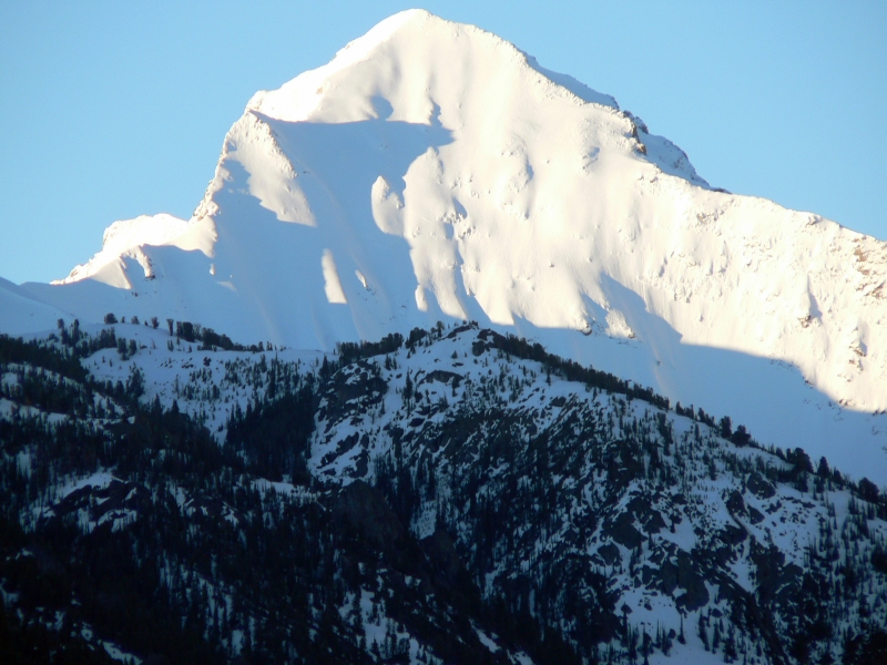
aren't you in the area-go git'er Originally Posted by BlurredElevens

 That pic is fucking money btw.
-
12-26-2007, 09:23 PM #14
is classy as fuck
- Join Date
- May 2004
- Location
- Colorado Cartel HQ
- Posts
- 15,931
I would be totally down, but I don't know what the snowpack is like up there right now. Sun Valley mags? Thoughts? Originally Posted by easyrdr
-
12-26-2007, 09:40 PM #15
Blank
- Join Date
- Sep 2004
- Location
- Sawtooth's
- Posts
- 1,336
Pulled from Sawtooth Avalanche Center. Lets go to Brundage tomorrow and ski some side country.
Today the overall avalanche danger is estimated to be MODERATE, but there are localized areas of CONSIDERABLE danger on steep recently wind loaded slopes.
The snowpack is currently not very trustworthy in my opinion. This is due to a highly variable early season snowpack, the presence of persistent weak layers and recent widespread wind activity. Slope by slope evaluation should take place as you move through the backcountry.
Today’s forecast calls for 2 to 4 more inches of new snow in the high country accompanied by light to moderate northwesterly winds. If the weather forecast pans out expect further wind slab development and increasing danger on wind deposited slopes.
The South and Central Valley still have a rather thin snowpack which is generally very weak throughout. Steep wind loaded terrain in the South and Central Valley could still produce an avalanche with the right trigger.
The North Valley, Salmon Headwaters and Sawtooth Mountains have a generally deeper and stronger snowpack, but persistent faceted grains can still be found in many locations. Solar aspects, ridgelines and exposed high elevation terrain in these areas likely have large grain facets near the bottom of the snowpack. The near surface facets that developed in mid December are likely slowly gaining strength, but are still present. Additionally there is now around 2 to 3 feet of newer snow sitting on top of that potential weak layer.
Over the last week we have seen a few wind events blow through our forecast area. Christmas Eve saw a wind event that seemed to affect almost all exposed slopes regardless of elevation. Be aware of recently deposited wind slabs, especially in areas with an overall thin weak snowpack and along steep exposed ridgelines. Many of these wind affected areas will be visually obvious at least until they get buried with a few inches of new snow. Other clues to their presence are texture changes, supportable hollow sounding slabs, cracking, whumpfing and recent natural releases in similar terrain.
Additional Discussion
As I mentioned earlier in this report the snowpack is currently overall not very trustworthy. The snow pack varies a lot depending where you go. For instance the Sawtooth Mountains have a much deeper and generally stronger snow pack than the South and Central Valleys. Reports from the Soldier Mountain area suggest that they received more snow in the last week and a half than the Ketchum area did however they typically also receive more wind.
There are certainly places folks can go right now and find reasonably safe snow to recreate on. However if folks were looking to get involved with an avalanche, there are areas in which that could also happen. Slope by slope evaluation, conservative decision making and good mountain travel techniques should remain a priority.
Over the last week we have seen a few wind events blow through our forecast area. Christmas Eve saw a wind event that seemed to affect almost all exposed slopes regardless of elevation. Be aware of recently deposited wind slabs, especially in areas with an overall thin weak snowpack and along steep exposed ridgelines. Many of these wind affected areas will be visually obvious at least until they get buried with a few inches of new snow. Other clues to their presence are texture changes, supportable hollow sounding slabs, cracking, whumpfing and recent natural releases in similar terrain.
-
12-30-2007, 02:30 PM #16
 Terrain connoissuer
- Join Date
- Nov 2004
- Location
- Massivetwoshits
- Posts
- 2,381
Is the road to Wildhorse open in the winter?
A fucking show dog with fucking papers
-
12-30-2007, 03:37 PM #17
Blank
- Join Date
- Sep 2004
- Location
- Sawtooth's
- Posts
- 1,336
I have been looking into this one a lot lately. I will send an email or two and see how far you can get back on the Trail Creek road. I don't think Wild Horse Road is plowed but a snowmobile from the Mackay side might make things a lot easier.
-
12-30-2007, 04:29 PM #18
Registered User
- Join Date
- Jun 2007
- Location
- Ketchum, ID
- Posts
- 37
Trail creek road is closed about a mile north of sun valley lodge. The best bet is definetly to go from the mackay side on sled up to the base as trail creek road has some pretty gnarly slide paths on it.

 Reply With Quote
Bookmarks