
Anybody seen the farmers almanac outlook for this winter yet? Or any other reputable outlooks for that matter? Googled it but couldn't really come up with much other than some north east stuff.
Results 1 to 25 of 26
Thread: Farmers Almanac Outlook?
-
08-18-2006, 09:43 AM #1

 Hater
Hater
- Join Date
- Oct 2003
- Location
- Durango, CO
- Posts
- 758
Farmers Almanac Outlook?
-
08-18-2006, 09:49 AM #2
Registered User
- Join Date
- Dec 2005
- Posts
- 3,609
the almanac predicted the big CO blizzard of 03
Preserving farness, nearness presences nearness in nearing that farness
-
08-18-2006, 09:51 AM #3
Registered User
- Join Date
- May 2005
- Posts
- 4,002
Acording to my personal theory - The Law of Averages - I'd say we're in for a dry spell. Hopefully just in the fall. Two months ago was way behind average on YTD precip & now we are ahead (Frickin rain). Course on the other hand with the extended drought down your way ('cept 2 winters ago) we're long over due.
Ullr, Bring it! to the Southern Rockies!
-
08-18-2006, 10:00 AM #4
 Registered Addict
- Join Date
- Nov 2005
- Location
- Wrong Coast
- Posts
- 414
The Farmers Almanac predicted a colder and snowier than average winter for the North East last year. I dont think 50 degrees and raining in mid January meets that prediction.

-
08-18-2006, 10:01 AM #5
Registered User
- Join Date
- Dec 2005
- Posts
- 3,609
man last year in the central mountains of CO was great, i hope that happens again, lovelands snow pack was super high by December
Preserving farness, nearness presences nearness in nearing that farness
-
08-18-2006, 10:06 AM #6
 Registered User
- Join Date
- Jan 2003
- Location
- nh
- Posts
- 8,221
What did you get on the North East? I got this forum which makes the North East winter sound good. But I'm not sure how they are getting to that conclusion with all that weather person talk. Originally Posted by Storm11
Last edited by Tuckerman; 09-13-2006 at 06:41 AM.
People should learn endurance; they should learn to endure the discomforts of heat and cold, hunger and thirst; they should learn to be patient when receiving abuse and scorn; for it is the practice of endurance that quenches the fire of worldly passions which is burning up their bodies.
--Buddha
*))
((*
*))
((*
www.skiclinics.com
-
08-18-2006, 10:07 AM #7
 Collator
- Join Date
- Mar 2004
- Location
- Wooded enclave
- Posts
- 1,769
I go by the wooly bear caterpillar. Haven't seen one yet this summer though.
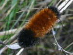
Narrow brown stripe=pow
Thick brown stripe=not so much pow.To the Thingmajigger!
-
08-18-2006, 10:09 AM #8
Registered User
- Join Date
- Jan 2003
- Location
- nh
- Posts
- 8,221
I hope thats not true I think I saw a all black one the other day. Originally Posted by milton
People should learn endurance; they should learn to endure the discomforts of heat and cold, hunger and thirst; they should learn to be patient when receiving abuse and scorn; for it is the practice of endurance that quenches the fire of worldly passions which is burning up their bodies.
--Buddha
*))
((*
*))
((*
www.skiclinics.com
-
08-18-2006, 10:14 AM #9
 on the other side
- Join Date
- Aug 2005
- Location
- grapes and grapes
- Posts
- 3,330
That means overhead pow all winter!
 "Climb the mountains and get their good tidings. The winds will blow their freshness into you, and the storms, their energy. Your cares and tensions will drop away like the leaves of Autumn." --John Muir
"welcome to the hacienda, asshole." --s.p.c.
-
08-18-2006, 10:21 AM #10
 Registered User
- Join Date
- Jan 2006
- Location
- BKLYN
- Posts
- 850
dr. schreiner predicts a snowy east coast for the upcoming winter. the old man's funny bone is tickling and he tore his hamstrings. the only other summer plagued by so many injuries for the old doctor resulted in unprecedented snow and the infamous blizzard of '94.
further, after analyzing the nymph hatches, larvae under rocks and the unusual rainbow activity in the willowemac; the good doctor has issued an all out bulletin for the northeast soldiers to be ready for a lot of snow.
but, be warned, he has been wrong before, resulting in multiples stonings. fortunately i know where he lives so we can stone him or just get stoned with him.
thank you good doctor.
-
08-18-2006, 10:23 AM #11
 SnowTime
- Join Date
- Jan 2006
- Location
- la la land
- Posts
- 5,816
March and April = ghey though Originally Posted by nick > jesus
`•.¸¸.•´><((((º>`•.¸¸.•´¯`•.¸.? ??´¯`•...¸><((((º>
"Having been Baptized by uller his frosty air now burns my soul with confirmation. I am once again pure." - frozenwater
"once i let go of my material desires many opportunities for playing with the planet emerge. emerge - to come into being through evolution. ok back to work - i gotta pack." - Slaag Master
"As for Flock of Seagulls, everytime that song comes up on my ipod, I turn it up- way up." - goldenboy
-
08-18-2006, 12:11 PM #12
 Used Register
- Join Date
- Sep 2001
- Location
- Before
- Posts
- 28,761
PROGNOSTIC DISCUSSION FOR LONG-LEAD SEASONAL OUTLOOKS
NWS CLIMATE PREDICTION CENTER CAMP SPRINGS MD
830 AM EDT THU AUG 17 2006
SUMMARY OF THE OUTLOOK FOR NON-TECHNICAL USERS
THE MAIN FACTORS WHICH USUALLY INFLUENCE SEASONAL CLIMATE INCLUDE
1) EL NINO AND LA NINA - WHICH TOGETHER MAKE UP EL NINO/SOUTHERN OSCILLATION OR
ENSO
2) TRENDS - APPROXIMATED BY THE DIFFERENCE BETWEEN THE MOST RECENT 10-YEAR MEAN
OF TEMPERATURE OR 15-YEAR MEAN OF PRECIPITATION FOR A GIVEN LOCATION AND TIME
OF YEAR AND THE 30-YEAR CLIMATOLOGY PERIOD (CURRENTLY 1971-2000)
3) TROPICAL 30-60-DAY OSCILLATION- WHICH MAY AFFECT CLIMATE VARIABILITY WITHIN
A SEASON
4) THE NORTH ATLANTIC OSCILLATION (NAO) AND THE PACIFIC NORTH AMERICAN (PNA)
PATTERNS
5) PERSISTENTLY DRY OR WET SOILS IN THE SUMMER AND SNOW AND ICE COVER ANOMALIES
IN THE WINTER.
6) AN OBJECTIVE CONSOLIDATION (CALLED CON IN THE TEXT) OF THE OCN, CCA, SMLR
AND CFS FORECASTS IS USED AS A FIRST-GUESS IN PREPARING THE FORECAST MAPS.
SST ANOMALIES ACROSS MOST OF THE EQUATORIAL PACIFIC CURRENTLY RANGE FROM
SLIGHTLY WARMER THAN NORMAL TO NEAR NORMAL... INDICATING PRIMARILY ENSO NEUTRAL
CONDITIONS. MOST PREDICTION TOOLS INDICATE THAT SST ANOMALIES WILL BE NEAR OR
SOMEWHAT ABOVE +0.5 DEG CENTIGRADE IN THE ENSO-SENSITIVE REGIONS OF THE PACIFIC
... SUGGESTING THAT NEUTRAL OR WEAK WARM EVENT CONDITIONS COULD HAVE SOME
IMPACT ON UNITED STATES CLIMATE IN THIS SERIES OF OUTLOOKS. UNTIL WE GET A
MORE DEFINITIVE IDEA OF THE LIKELIHOOD AND INTENSITY OF A WARM EVENT IN THE
NEXT FEW MONTHS... WE HAVE ELECTED TO CLOSELY FOLLOW THE CONSOLIDATION FORECAST
WHICH CALLS FOR DRIER THAN MEDIAN PRECIPITATION OVER THE SOUTHEAST STATES
DURING THE CORE OF THE UPCOMING COLD SEASON ...NAMELY NDJ 2006 - DJF 2006 - AND
JFM 2007. HISTORICAL COMPOSITES OF WEAK WARM EPISODE CONDITIONS ALSO TEND TO
FAVOR BELOW MEDIAN AMOUNTS OF PRECIPITATION ACROSS THE SOUTHEAST FOR THE THREE
SEASONS JUST MENTIONED. ONGOING ASSESSMENTS OF THE GLOBAL CLIMATE SYSTEM MAY
REQUIRE US TO MAKE SIGNIFICANT CHANGES TO THE UPCOMING WINTER TEMPERATURE AND
PRECIPITATION FORECASTS AS THE STATE AND MAGNITUDE OF ENSO BECOMES MORE CLEAR.
THE TEMPERATURE OUTLOOK FOR SEP-OCT-NOV (SON) 2006 CALLS FOR WARMER THAN NORMAL
CONDITIONS OVER MOST OF THE U.S. WEST OF THE MISSISSIPPI RIVER. ABOVE NORMAL
TEMPERATURES ARE ALSO EXPECTED ACROSS THE GREAT LAKES - NEW ENGLAND AND THE
FLORIDA PENINSULA AS WELL AS THE EASTERN HALF OF ALASKAS SOUTHERN COASTLINE.
ELSEWHERE THERE ARE EQUAL CHANCES OF WARMER-THAN... COOLER-THAN... OR NEAR-
NORMAL TEMPERATURES DURING SON.
THE PRECIPITATION OUTLOOK FOR SEP-OCT-NOV (SON) 2006 CALLS FOR BELOW MEDIAN
PRECIPITATION IN MUCH OF THE MIDWEST... AND THE PACIFIC NORTHWEST. THE FIRST IS
DUE MAINLY TO TRENDS... WHILE THE LATTER IS INDICATED BY A NUMBER OF TOOLS.
THE CHANCES FOR ABOVE MEDIAN PRECIPITATION ARE ENHANCED OVER FLORIDA DUE TO
LONG TERM TRENDS AND THE EXPECTATION OF AN ACTIVE ATLANTIC HURRICANE SEASON.
HOWEVER ... IT SHOULD BE EMPHASIZED THAT THIS PRECIPITATION OUTLOOK SHOULD NOT
BE USED TO INFER CHANGES IN HURRICANE STRIKE PROBABILITIES. ABOVE MEDIAN
PRECIPITATION IS ALSO PREDICTED OVER MUCH OF THE NORTHERN GREAT PLAINS WHICH IS
HEAVILY FAVORED BY THE CONSOLIDATION TOOL.
BASIS AND SUMMARY OF THE CURRENT LONG-LEAD OUTLOOK
NOTE: FOR GRAPHICAL DISPLAYS OF THE FORECAST TOOLS DISCUSSED BELOW SEE:
HTTP://WWW.CPC.NCEP.NOAA.GOV/PRODUCT...TOOLS/BRIEFING
CURRENT ATMOSPHERIC AND OCEANIC CONDITIONS
SSTS ALONG THE EQUATOR IN THE PACIFIC ARE MOSTLY NEAR OR SLIGHTLY ABOVE +0.5
DEG C OF NORMAL. THE SSTS IN THE NINO 3.4 REGION... A CRITICAL INDICATOR FOR
THE ENSO STATE... CURRENTLY AVERAGE ABOUT 0.4 DEG C ABOVE NORMAL. THE LOW
LEVEL EASTERLY WINDS (AT 850 MB) IN THE TROPICAL PACIFIC AVERAGED SOMEWHAT
WEAKER THAN NORMAL DURING THE MONTH OF JULY...WHILE THE SOI INDEX WAS NEGATIVE
FOR THE THIRD CONSECUTIVE MONTH. THESE INDICATORS SUGGEST THAT ENSO IS STILL
IN A NEUTRAL PHASE BUT APPEARS TO BE SLOWLY TRENDING TOWARD A WEAK WARM EVENT.
THE UPPER OCEAN HEAT CONTENT IN THE EQUATORIAL PACIFIC HAS INCREASED MARKEDLY
IN THE LAST FIVE MONTHS ... AND IS NOW NOTICEABLY ABOVE THE LONG TERM AVERAGE.
MADDEN-JULIAN OSCILLATION (MJO) ACTIVITY CONTINUES TO BE WEAK OVER THE TROPICAL
PACIFIC.
PROGNOSTIC DISCUSSION OF SST FORECASTS
A CONSOLIDATION OF NCEP SST MODELS PREDICTS THAT NINO 3.4 SSTS WILL MOST LIKELY
PEAK NEAR OR SLIGHTLY ABOVE +0.5 DEG C. THERE IS MODERATE SPREAD AMONG MODEL
SOLUTIONS FOR THE NEXT FEW MONTHS... INDICATING SOME UNCERTAINTY IN THE
FORECAST. MODEL SPREAD DOES INCREASE SUBSTANTIALLY DURING THE SPRING AND
SUMMER OF 2007. MODELS SUGGEST THAT THE CHANCES THAT THE NINO 3.4 SSTS WILL
EXCEED THE 0.5 DEGREE C THRESHOLD FOR MINIMAL EL NINO RELATED IMPACTS PEAK
AROUND 47 PERCENT IN OND 2006 ... DIMINISHING TO AROUND 40 PERCENT IN BOREAL
WINTER (DJF 2006/7)...AND DROPPING OFF RAPIDLY THEREAFTER. THE PREDICTED
CHANCES FOR LA NINA CONDITIONS ARE NEGLIGIBLE. THE ENSO PHASE IS EXPECTED TO
RANGE FROM NEUTRAL TO WEAK WARM CONDITIONS WHICH WILL LIKELY PREVAIL THROUGHOUT
THIS UPCOMING COLD SEASON.
PROGNOSTIC TOOLS USED FOR U.S. TEMPERATURE AND PRECIPITATION OUTLOOKS
THE OUTLOOK FOR SON 2006 THROUGH SON 2007 IS BASED ON THE CFS... THE
MULTI-MODEL ENSEMBLE FROM IRI... AND THE CDC-CCA RENDERING OF THE MOST LIKELY
CONSENSUS FORECAST OF SEVERAL DYNAMICAL MODEL FORECASTS... AS WELL AS CCA...
ECCA... SMLR... AND OCN. FORECASTS PRIMARILY REFLECT THE CONSOLIDATED
TEMPERATURE AND PRECIPITATION PRODUCTS (A SKILL-WEIGHTED OBJECTIVE BLEND OF
CFS... CCA... SMLR... AND OCN)...WITH CONSIDERATION OF A POTENTIAL COLD SEASON
WEAK EL NINO. THE OUTLOOKS FOR MAM 2007 THROUGH SON 2007 ARE BASED LARGELY ON A
CONSOLIDATION OF CCA... SMLR... AND OCN (CFS IS NOT AVAILABLE AFTER LEAD 6). A
STATISTICAL FORECAST TOOL BASED ON ANTECEDENT SOIL MOISTURE CONDITIONS (CAS)
HAD MODEST INFLUENCE ON THE LEAD 1 OUTLOOK FOR SON 2006.
PROGNOSTIC DISCUSSION OF OUTLOOKS - SON 2006 TO SON 2007
TEMPERATURE:
TEMPERATURE PROBABILITIES FOR SON 2006 ARE SIMILAR TO THOSE ISSUED LAST MONTH
WITH SLIGHTLY EXPANDED COVERAGE OF ABOVE NORMAL MEAN TEMPERATURES ACROSS THE
NORTHWEST U.S....AND THE INTRODUCTION OF WARMER THAN NORMAL TEMPERATURES FOR
THE PANHANDLE OF ALASKA. MOST OF THE TOOLS SUPPORT THESE AREAS OF RELATIVE
WARMTH. THE AREAS WITH ELEVATED PROBABILITIES FOR WARMTH (40% OR GREATER)
INCLUDE NEW ENGLAND - THE CENTRAL GREAT PLAINS - SOUTH FLORIDA - AND THE DESERT
SOUTHWEST. THE OUTLOOKS FOR OND 2006 THROUGH FMA 2007 ARE BASED MAINLY ON THE
CONSOLIDATION TOOL WHICH GENERALLY FAVORS WARMTH... THOUGH TEMPERED SLIGHTLY BY
THE POSSIBILITY OF WEAK WARM EPISODE CONDITIONS THIS WINTER. OUTLOOKS FOR MAM
2007 AND BEYOND ARE BASED PRIMARILY ON THE CONSOLIDATION TOOL (THE CFS
COMPONENT DROPS OUT AFTER LEAD 6) WHICH IS ALMOST ENTIRELY A REFLECTION OF
TEMPERATURE TRENDS.
PRECIPITATION:
BELOW MEDIAN PRECIPITATION IS INDICATED ACROSS MUCH OF THE MIDWEST FOR SON 2006
DUE TO RECENT TRENDS. ABOVE MEDIAN PRECIPITATION FOR FLORIDA FOR LEAD 1 IS
FROM LONG TERM TRENDS AND AN ANTICIPATED ACTIVE ATLANTIC HURRICANE SEASON. FOR
THE UPCOMING BOREAL WINTER THE MAIN CHALLENGE WILL BE ASSESSING THE LIKELIHOOD
AND STRENGTH OF A WARM EVENT AND ITS POTENTIAL IMPACTS ON (PRIMARILY) THE LOWER
48 STATES. DURING WINTER (DJF 2006/7)... THERE IS FAIRLY GOOD AGREEMENT AMONG
THE TOOLS FAVORING AN AREA OF ABOVE MEDIAN PRECIPITATION CENTERED OVER THE
SOUTHERN PLAINS AND RELATIVE DRYNESS ACROSS BOTH THE NORTHWESTERN AND
SOUTHEASTERN U.S.. THE REMAINING OUTLOOKS HAVE BEEN MODIFIED ONLY SLIGHTLY
FROM THOSE ISSUED FOR CORRESPONDING SEASONS LAST MONTH.
NOTE - AREAS OF UNCERTAINTY THAT FORMERLY WERE LABELED CL (CLIMATOLOGICAL
PROBABILITIES) ARE NOW LABELED EC (EQUAL CHANCES).
FORECASTER: ANTHONY ARTUSA
STARTING WITH THE SEASONAL OUTLOOK RELEASED IN FEBRUARY, 2006, THE GLOSSARY OF
TERMS WILL NO LONGER APPEAR WITH THIS MESSAGE.
INSTEAD, TERMS THAT ARE IN THE GLOSSARY WILL BE LINKED TO THEIR DEFINITION.
FOR A DESCRIPTION OF THE STANDARD FORECAST TOOLS - THEIR SKILL - AND THE
FORECAST FORMAT PLEASE SEE OUR WEB PAGE AT
HTTP://WWW.CPC.NCEP.NOAA.GOV/PRODUCT...0DAY/DISC.HTML
(USE LOWER CASE LETTERS)
INFORMATION ON THE FORMULATION AND SKILL OF THE CAS FORECASTS MAY BE FOUND AT:
HTTP://WWW.CPC.NCEP.NOAA.GOV/SOILMST/FORECASTS.HTML (USE LOWERCASE LETTERS)
NOTES - THESE CLIMATE OUTLOOKS ARE INTENDED FOR USE PRIOR TO THE START OF
THEIR VALID PERIOD. WITHIN ANY GIVEN VALID PERIOD OBSERVATIONS AND SHORT
AND MEDIUM RANGE FORECASTS SHOULD BE CONSULTED.
THIS SET OF OUTLOOKS WILL BE SUPERSEDED BY THE ISSUANCE OF THE NEW SET NEXT
MONTH ON THU SEP 21 2006.
1971-2000 BASE PERIOD MEANS WERE IMPLEMENTED EFFECTIVE WITH THE MAY 17, 2001
FORECAST RELEASELast edited by Buster Highmen; 08-18-2006 at 12:22 PM.
Merde De Glace On the Freak When Ski
>>>200 cm Black Bamboo Sidewalled DPS Lotus 120 : Best Skis Ever <<<
-
08-18-2006, 12:15 PM #13
Used Register
- Join Date
- Sep 2001
- Location
- Before
- Posts
- 28,761
Here's more gibberish:
http://www.cpc.noaa.gov/products/predictions/90day/
With pretty maps for the illiterate.Merde De Glace On the Freak When Ski
>>>200 cm Black Bamboo Sidewalled DPS Lotus 120 : Best Skis Ever <<<
-
08-18-2006, 12:18 PM #14
Used Register
- Join Date
- Sep 2001
- Location
- Before
- Posts
- 28,761
And here's the one we want to see for CO in Feb-Mar-Apr 2007 (this is precip)

(green is good)Merde De Glace On the Freak When Ski
>>>200 cm Black Bamboo Sidewalled DPS Lotus 120 : Best Skis Ever <<<
-
08-18-2006, 12:26 PM #15
 The Book of Love
- Join Date
- May 2002
- Location
- Huh?
- Posts
- 10,908
If ^ that holds true, then this could be the year I get back to Taos...
"I knew in an instant that the three dollars I had spent on wine would not go to waste."
-
08-18-2006, 12:31 PM #16
Used Register
- Join Date
- Sep 2001
- Location
- Before
- Posts
- 28,761
Taos, when they have snow, was my fav ski area. It r00ls.
Merde De Glace On the Freak When Ski
>>>200 cm Black Bamboo Sidewalled DPS Lotus 120 : Best Skis Ever <<<
-
08-18-2006, 03:26 PM #17
 Registered User
- Join Date
- Jul 2006
- Posts
- 58
Same here, have'nt seen one as of yet. Originally Posted by milton
The last three winters (on the EC) they were right on!
If this years wooly bear resembles any thing like the past three years....I'm gonna stomp it into the ground!Press "1" for English. Press "2" to be deported
-
08-18-2006, 08:51 PM #18
Registered User
- Join Date
- Aug 2006
- Location
- Central Mass, USA
- Posts
- 79
very technical. Dunno about the Almanac. They're funny - sometimes they're deadon but mostly I think it's luck. Anyone heard from Roemer yet this year? Here's to hoping the past southern storm track crap in NE moves up a little this year - I'm tired of clearing out snow at 5AM only to drive 3 hours north and find they got none

-
08-18-2006, 08:54 PM #19
 Que demande le peuple?
- Join Date
- Mar 2005
- Location
- Crystal Mtn, WA
- Posts
- 1,454
ahem.
It's gonna be goooooooooooood.I can't understand why people are frightened of new ideas. I'm frightened of the old ones.
-
08-19-2006, 10:29 PM #20
 under the radar
- Join Date
- Oct 2005
- Location
- 95 minutes from Chair 1
- Posts
- 939
yayyyyy!!!
oauef;oasdi;asdiofj!!!!!!!!!!
bldjalsdkfja;lsdkfj;a!!!!!!!
fuck yah!
That FMA '07 just came out two days ago, that's the first I've seen w/ the Above av's for NM!!
Jah knows we deserve it!
fuk yah!!!!
but, on a serious note:
i'd stay away from taos. you wouldn't like it. it's not for folks like you. it's no good, at all, so just go to wolf creek or angel fire or somthing. There is absolutely no fancy plaid steezesuits and hardly anyone hits the park, so you probably would like it.
almost no one's on bromodels, no one has pennies glued to their skis and no one knows what a 'maggot' is. so, if I were you, I'd go to wolf creek. they get better snow, anyway.
-
08-20-2006, 12:44 AM #21
 Upgraded to JH from LCC
- Join Date
- May 2003
- Location
- JH, WY
- Posts
- 2,052
If taos gets nailed I'm going, i wanna compete there if a comp is there this year.
Always charging it in honor of Flyin' Ryan Hawks.
-
08-20-2006, 08:33 AM #22
under the radar
- Join Date
- Oct 2005
- Location
- 95 minutes from Chair 1
- Posts
- 939
Originally Posted by Altaholic

didn't you read what I said? it's not for folks like you.
go for it, huck your meat and double up Bamboo nose. you might take home the fat purse! sickkkkk brrooo!
-
08-20-2006, 03:20 PM #23
 Ogdenero
- Join Date
- Sep 2004
- Location
- The OG
- Posts
- 590
Settle down and let me make you a early-morning drink. Altah has a good a shot as anyone I saw there at the last comp. Those fuckers got real lucky; the conditions were perfect for that comp. Anything different and there would'a been carnage, as you already know. 80ft+ into those chutes, perfect conditions. Hope to make some SW turns with ya this winter.
-
08-20-2006, 06:53 PM #24
under the radar
- Join Date
- Oct 2005
- Location
- 95 minutes from Chair 1
- Posts
- 939
The conditions for the last comp were unreal. I was just giving Altah I hard time.
-
09-12-2006, 08:48 PM #25
 Registered User
- Join Date
- Mar 2006
- Location
- Tokyo, Japan
- Posts
- 1,964
Just out (at least on bloomberg news) Old Farmer's Almanac Predicts Colder Winter for US. Predicting -8% vs average and more snow

 Reply With Quote
Bookmarks