
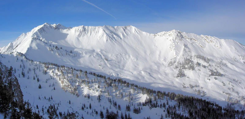
Didn't want to hijack your Wasatch obs thread. As a backcountry jong, tell me about this pic. What I see (in particular the big face(s)):
Wind's been blowing right-to-left.
Not south facing.
Snow's been sifted.
I'm unknowledgeable enough to not hit that slope, mainly due to terrain consequences. If I did, I'd go the 1/2 closer to camera face, probably trying to follow the subtle ridge on the shadow boundary down to the trees.
My question is, what does that slope say to you (given no knowledge of the underlying snowpack)? In particular, what does that wind-sifted snow mean? Is it a slab-builder when the snowpack is still obviously thick?
Thanks.
Results 1 to 8 of 8
Thread: Tell me about this pic
-
12-07-2005, 10:43 PM #1
 Registered User
- Join Date
- Aug 2005
- Posts
- 1,788
Tell me about this pic
-
12-08-2005, 12:25 AM #2
 Hiding in AK
- Join Date
- Oct 2003
- Location
- Was UT, AK, now MT
- Posts
- 14,581
The slope in question has a east aspect, with maybe a slight N aspect. The storm the night before came in from the NW.
Sounds like your route finding is reasonable. With the first choice being to completely avoid this one until the Wasatch Powder Birds drop 50 bombs on it to test it.
-
12-08-2005, 01:42 AM #3
Registered User
- Join Date
- Aug 2005
- Posts
- 1,788
Other stuff I know:
It's been really cold, so the snow would have had low density, however ...
It's been really windy, so the snow would've packed down tighter.
I guess what I'm wondering is whether there is potential for either upside-down snow or one big thick slab on that slope. Given a day to kill, I'd probably be willing to head up the little ridge roughly middle of slope and dig a few pits/do a few tests on the way up.
-
12-08-2005, 10:57 AM #4
 Registered Offender
- Join Date
- Jul 2004
- Location
- not far from snowbird
- Posts
- 2,244
it's not just what's on the surface there but what lies beneith. we've had trouble with shallow rocky areas that face E to NW around here and there are a couple persistent weak layers that are only now beginning to settle down. if you lay a new slab on top of it you need to see how the layers are reacting to the new weight. I would think that slab may be near the 1F range but that's just a guess. the slab beneith it should now be P-hard and maybe capping the weak layers below(?). that whole area is not all that deep right now. bottom line is that most people wouldn't trust a new windslab over recently active PWKL's.
here's the rest of the story:


-
12-08-2005, 08:42 PM #5
Registered User
- Join Date
- Aug 2005
- Posts
- 1,788
Thanks APD. That last pic certainly puts it in perspective. Terrain consequences have shot up a bit
 . The last pic makes the slope angle look higher, too. I'm not good at judging angles - low to mid 30°s?
Last edited by Toby; 12-08-2005 at 08:45 PM.
-
12-08-2005, 10:09 PM #6
Registered Offender
- Join Date
- Jul 2004
- Location
- not far from snowbird
- Posts
- 2,244
there are so many different angles over there that i wouldn't know where to begin. the diagonal slope looks to be in the mid to upper 30's (35-38). directly lookers left i'd say mid 40's plus(?).
-
12-09-2005, 02:38 PM #7
Registered User
- Join Date
- Dec 2004
- Posts
- 493
Yet another view.
Those are primarily wind ripples from the northerly winds during the storm.
There is some loading occuring on, mainly, slopes with a southerly and easterly facing aspect. Those aspects received significant sun prior to the storm and were crusted. The northeast facing with the actual wind ripples is seldom skied as it is difficult to access.
Since the underlying snow cover was mostly without facets, bonding during the storm of new with old was the question during and immediatly after the storm.
Slope angles range from the low twenties to over fifty.
Waiting for bonding to occur and realizing older layering was not a factor resulted in this.
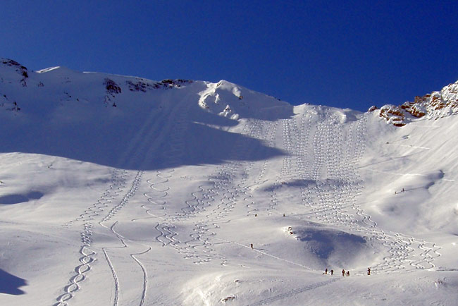
The area shown in the original picture had not been skied at the time of the last picture but may well have been undercut by now.
-
12-09-2005, 03:52 PM #8
Registered Offender
- Join Date
- Jul 2004
- Location
- not far from snowbird
- Posts
- 2,244
wra,
looks like people are trying to get the jump on the powder turds. i'd hate to see cardiac ridge on the weekend.


 Reply With Quote
Bookmarks