
So I'm going to include a unit on avalanche awareness the my high school geology class that I'm teaching.
As part of the final assignment for the kids I'd like to give them a USGS topo map and pictures of an area and ask them to identify the most slide-prone areas and an appropriate ascent and descent route.
I've decided on the area across the street from Alta (from Grizzly Gulch to Mt. Sup.) as being an ideal site due to the wealth of data available.
However, I've yet to come across just the right photo. If anyone could help me out by posting here I'd appreciate it (old TR's, scenics from High Rustler, etc.).
Results 1 to 23 of 23
Thread: LCC photos needed
-
11-09-2005, 09:09 AM #1

 Registered User
- Join Date
- Oct 2003
- Location
- Anchoragua
- Posts
- 1,098
LCC photos needed
-
11-09-2005, 09:19 AM #2
 speakerhead
- Join Date
- Nov 2004
- Location
- Boston
- Posts
- 439

 Ski like no one is watching!
-
11-09-2005, 10:33 AM #3
 Registered Offender
- Join Date
- Jul 2004
- Location
- not far from snowbird
- Posts
- 2,244
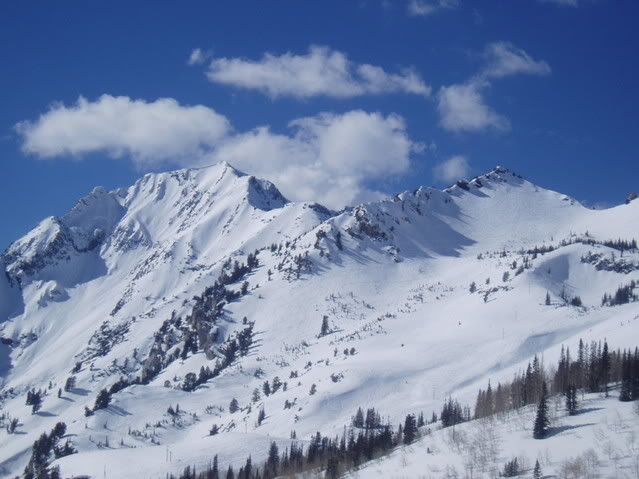
i'll post a few at a time:


-
11-09-2005, 11:02 AM #4
Registered Offender
- Join Date
- Jul 2004
- Location
- not far from snowbird
- Posts
- 2,244
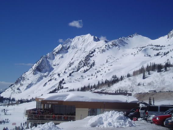
grizzly gulch/wolverine bowl

i can't find the ones i'm looking for right now but i'll look later.
-
11-09-2005, 11:12 AM #5
Registered User
- Join Date
- Dec 2004
- Posts
- 493
Why I don't skin up the middle of Toledo Bowl.

Skin track exits looker's right prior to entering the choke because,

Other skiers'll getcha.

-
11-09-2005, 11:30 AM #6
Registered User
- Join Date
- Jul 2005
- Location
- Lebanon, NH
- Posts
- 831
-
11-09-2005, 07:35 PM #7

 Irrie Rasta Dog Copilot
- Join Date
- Apr 2005
- Location
- A LSD Steakhouse somewhere in the Wasatch
- Posts
- 13,262
 "When the child was a child it waited patiently for the first snow and it still does"- Van "The Man" Morrison
"I find I have already had my reward, in the doing of the thing" - Buzz Holmstrom
"THIS IS WHAT WE DO"-AML -ski on in eternal peace
"I have posted in here but haven't read it carefully with my trusty PoliAsshat antenna on."-DipshitDanno
-
11-09-2005, 07:58 PM #8
 Teacherin'
- Join Date
- Nov 2004
- Location
- Up in ya face!
- Posts
- 3,839
This thread is cool for two reasons:
1. 'cause that'll be the sweetest lesson ever.
2. 'cause a bunch of people chimed in with good stuff to help out a teacher and his students.
-
11-09-2005, 08:07 PM #9
 Registered User
- Join Date
- Oct 2003
- Location
- Under the bridge, down by the river
- Posts
- 4,882
Am I the only one frightened that nhtele is teaching children?
-
11-09-2005, 09:51 PM #10
 medical tool
- Join Date
- Oct 2003
- Location
- salt lick
- Posts
- 262
i am a little frightened that he has a whole class of teenage girls to himself.
If carrots got you drunk; rabbits would be fucked up.
- Mitch Hedberg
-
11-09-2005, 10:02 PM #11
Registered User
- Join Date
- Oct 2003
- Location
- Under the bridge, down by the river
- Posts
- 4,882
Exactly my thoughts.
"Girls, this is what an avalanche feels like"
-
11-10-2005, 08:38 AM #12
Registered User
- Join Date
- Oct 2003
- Location
- Anchoragua
- Posts
- 1,098
 Originally Posted by El Kabong
Seriously. I was fucked up out of my mind the other night and *briefly* considered waking up one of the girls and telling her I kinda like her. Sidenote: There are NO remotely attractive women in this town and I've lived here 2+ months.
Thanks for all the help. I'm totally procrastinating on grading by planning this lab/unit.
-
11-10-2005, 09:05 AM #13
 Media Whore
- Join Date
- Nov 2003
- Location
- Stuck in perpetual Meh
- Posts
- 35,244
DANGER....DANGER....DANGER.... Originally Posted by nhtele
-
11-10-2005, 09:12 AM #14
 Hiding in AK
- Join Date
- Oct 2003
- Location
- Was UT, AK, now MT
- Posts
- 14,599
Originally Posted by K-Stormchaser
This one shows the smog quite well.
-
11-10-2005, 09:20 AM #15
 Registered User
- Join Date
- Dec 2003
- Location
- Fort Fun / Rabbit Ears
- Posts
- 1,180
nhtele,
I have some great sequence shots on paper from Hellgate sliding. I held down my shutter and I have 16 shots of it coming down and crossing the road. The same goes for Superior I think I have 17 shots. Both were after a huge dump in January 94.
I will try an scan them today.
-
11-10-2005, 10:23 AM #16
Registered User
- Join Date
- Oct 2003
- Location
- Anchoragua
- Posts
- 1,098
Originally Posted by danadog
Wow, that would be some awesome avy porn and would be great in a slideshow - thanks.
-
11-10-2005, 10:25 AM #17
 Opinionated User

- Join Date
- Nov 2004
- Location
- Utard
- Posts
- 1,684
Yep, one sexy avatar! Originally Posted by danadog

(Not hijacking thread, just commenting.)This touchy-feely Kumbaya shit has got to go.
-
11-11-2005, 12:59 AM #18
Teacherin'
- Join Date
- Nov 2004
- Location
- Up in ya face!
- Posts
- 3,839
Originally Posted by nhtele
Don't fancy a long career in teaching eh?
-
11-11-2005, 09:18 AM #19
Registered User
- Join Date
- Oct 2003
- Location
- Anchoragua
- Posts
- 1,098
Originally Posted by biggins
Well, I was whiskey drunk and listening to Slayer the other day and as a result considered resigning. So I guess, no.
-
11-11-2005, 11:07 AM #20
Registered User
- Join Date
- Dec 2003
- Location
- Fort Fun / Rabbit Ears
- Posts
- 1,180
Need help posting the slide pics!
I started scanning the pics last night and I can't seem to re-size them small enough.
Let me know if anyone has any advice, or if I can email them to someone who has the know how to post them.
Thanks
-
11-11-2005, 05:25 PM #21
Registered User
- Join Date
- Oct 2003
- Location
- Anchoragua
- Posts
- 1,098
Originally Posted by danadog
You can e-mail straight to me at
colin DOT o ATTTT dartmouth DOT edu
As far as enjoyment by the wider community, I'm afraid I'm no use.
-
11-11-2005, 07:00 PM #22
 Royale With Steeze
- Join Date
- May 2005
- Location
- Germania
- Posts
- 671
You might be alright with the teacher student relationship in Europe. I've got a mate who went over to Germany to teach English and hooked up with a student, he's 25 and she was 19. Then again, another mate of mine, teaching English in Japan, got sacked for fucking his students (ages unknown).
-
11-11-2005, 07:12 PM #23
Teacherin'
- Join Date
- Nov 2004
- Location
- Up in ya face!
- Posts
- 3,839
GRRRREAT motivation to go into teaching. I joke about it plenty, and I ain't gonna judge here, but you have to conciously not think about your students in this way. You find them hot, 'cause you are human, but you're not doing your job if you are focused on any kind of attraction. Originally Posted by Incompetent Boob
Long after they are your students- that is an entirely different story. And I'm no hypocrite, I broke up with a long-time girlfriend and began teaching grad-students at the exact same time. I haven't had the cojones to indulge yet, but I sure-as-shit consider it all the time with now-former students.
NHT- I will say that a Swiss, girls boarding school has gotta be pretty rough on the ol' concience. Best of luck, masterbate often.

 Reply With Quote
Bookmarks