
Thanks, I get it now. I need to actually work these sections instead of giving them the 1 half-assed go and rolling on...Originally Posted by SJG

That's obnoxious but par for the Springville course, place is as straight as they come.
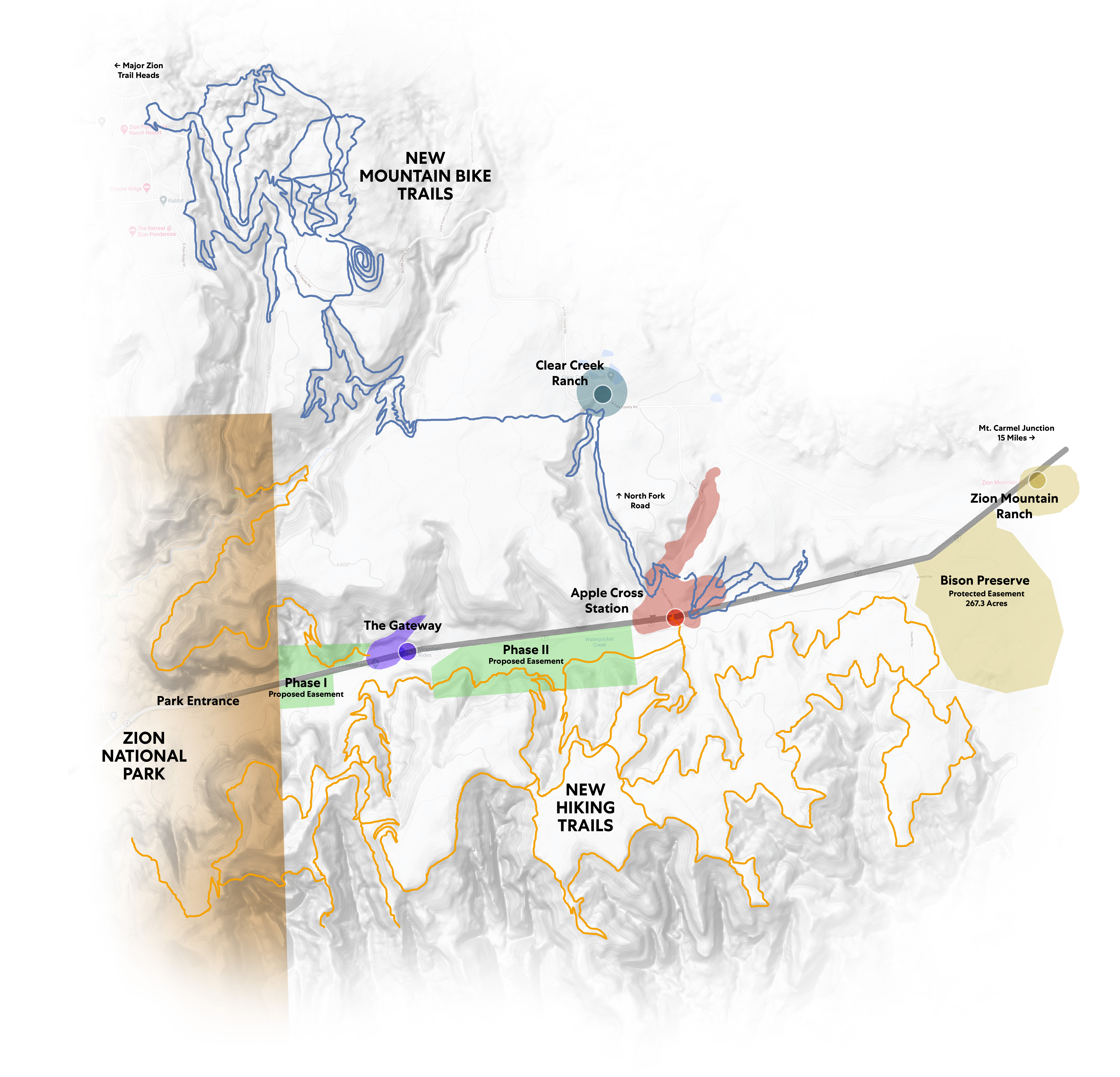
Good beta for the Hobble area.
One of you guys' Strava probably thinks it's on the E coast with that 2 hour time difference...
Results 976 to 1,000 of 2828
Thread: Wasatch Dirt Thread
-
05-14-2021, 04:36 PM #976

 "touring guy"
- Join Date
- Jan 2009
- Location
- SLC burbs
- Posts
- 4,429
"Your wife being mad is temporary, but pow turns do not get unmade" - mallwalker the wise
-
05-14-2021, 04:40 PM #977
pura vida
- Join Date
- Mar 2006
- Location
- The bottom of LCC
- Posts
- 5,749
Nah, mine stopped recording half way up the climb for some reason, I restarted it at the top.
-
05-14-2021, 04:42 PM #978
 Registered User
- Join Date
- Nov 2010
- Location
- Montrose, CO
- Posts
- 4,783
Totally, I'll hit you up when I make it down that way! Originally Posted by joetron
-
05-16-2021, 07:28 PM #979
 Registered User
- Join Date
- Oct 2003
- Location
- slc
- Posts
- 19,246
Primo conditions in Park City this afternoon and no one was out, totally deserted. Moosehouse is as good as it gets, one down tree and a couple very small snow patches near the top of Red Bull. I'm officially a convert to climbing John's.
-
05-16-2021, 09:10 PM #980
pura vida
- Join Date
- Mar 2006
- Location
- The bottom of LCC
- Posts
- 5,749
Best climb at PCMR.
-
05-17-2021, 08:17 AM #981
 Registered User
- Join Date
- Aug 2010
- Location
- Park City
- Posts
- 1,922
I ride there all the time, and that is unfortunately a very low bar. Originally Posted by dfinn
-
05-17-2021, 09:12 AM #982
 Registered User
- Join Date
- Mar 2010
- Posts
- 404
haha pedaling up sweenys/johns is good fun. Originally Posted by Canada1
Anyone else dip out on Payday to avoid upper Jennies routing?
My climbing go-to's for the last few years...King, Flat Iron, Thaynes, McConkeys etc...Just get me to the top fast as possible, no fuss, no people....Dont know what it is but I really enjoy spinning up King Road.
Been riding a ton in PC the last week, its been awesome really peaceful/quiet.
after about 10 minutes of me yelling it had enough
Lots of animals lurking on the trails...saw a herd of about 30 Elk off CMG yesterday. My dog had its first encounter with a porcupine(one of my worst fears for her out on the trail) luckily she walked away with only 4 quills in herLast edited by mar123; 05-17-2021 at 11:36 AM.
-
05-17-2021, 11:18 AM #983
"touring guy"
- Join Date
- Jan 2009
- Location
- SLC burbs
- Posts
- 4,429
Damn that PC dirt look tasty!
It's already moon dust season if you go lower, spun up MoPi on Sat and it was as dry as last October. Surprisingly quiet though and the brush hasn't overtaken the LittleMtn ridge yet so it made for a fun outing.
Went for the annual spin around Promontory with Ms Boissal on Sunday, Princess Di is as pleasant as ever from the Tollgate side but it's already dry and dusty on the back. Lots of prairie dogs and marmots frolicking about and barely any aggressive brush for now, makes for a great mellow XC loop. Bonus: the culvert under I80 is fully rideable, it's a bit challenging with some invisible big rocks hiding in the current but it goes. Ms Boissal beatered 2/3 of the way through and had to do the walk of shame in the water.
"Your wife being mad is temporary, but pow turns do not get unmade" - mallwalker the wise
-
05-17-2021, 01:40 PM #984
Registered User
- Join Date
- Oct 2003
- Location
- slc
- Posts
- 19,246
I'm definitely a fan of directissimo climbing. I seem to be the only one here who's into climbing the P-gulch road at Snowbird. It's a sufferfest, but it's empty, you'll never complain about Puke Hill ever again, you can go in the afternoon/evening when BMT is closed to uphill traffic (which, for me, the one-way aspect is half the point of riding BMT), and I can literally go up and down in the time it would take just to top out if I climbed the trail. Originally Posted by mar123
Honestly, while the dirt was mostly awesome, it was a little freakishly dry for May 16. It might be long dusty summer. If only deep dust rode like deep pow.... Originally Posted by Boissal
-
05-17-2021, 02:00 PM #985
"touring guy"
- Join Date
- Jan 2009
- Location
- SLC burbs
- Posts
- 4,429
Agreed, it's scary how dry it already is. You can tell some section of MoPi still had snow on them a week ago and they're already decomposing into dust. Reservoirs are freaking low as hell too, Little Dell looks like it's already at July level. We went to Rockport after riding Princess Di yesterday and the amount of exposed beach is shocking. Originally Posted by Dantheman
"Your wife being mad is temporary, but pow turns do not get unmade" - mallwalker the wise
-
05-17-2021, 02:16 PM #986
Registered User
- Join Date
- Dec 2015
- Posts
- 670
FWIW LCC from China Wall down is running as good as it gets.
This moisture is going to help most everything, just need more of it
-
05-17-2021, 02:49 PM #987
 searching for downtime
- Join Date
- Aug 2005
- Location
- in the brew room
- Posts
- 2,396
i'll prob do it once or twice this year for the reasons you've stated. plus i can take off my helmet and deal with my sweat issues much easier Originally Posted by Dantheman

-
05-17-2021, 03:15 PM #988
Registered User
- Join Date
- Oct 2003
- Location
- slc
- Posts
- 19,246
Heh. The only time you might need a helmet on that climb is if you fall over trying to clean one of the extra-hard spots.
-
05-17-2021, 11:04 PM #989
pura vida
- Join Date
- Mar 2006
- Location
- The bottom of LCC
- Posts
- 5,749
Wasatch Dirt Thread
The mid lower part of rush got some love. Nothing earth shattering but it’s way better than before and they threw a few fun size jumps in and some nice berms.
Christ on a candlestick it was busy in CC tonight! Easily the most amount of people I’ve seen out there in my 15’ish years of riding there. Was it opening day for high school bike training or something?
-
05-17-2021, 11:33 PM #990
 Registered User
- Join Date
- Aug 2020
- Location
- SLC
- Posts
- 2,633
Anyone know if the "Brink" loop is close to ready?
-
05-18-2021, 10:54 AM #991
Registered User
- Join Date
- Oct 2003
- Location
- slc
- Posts
- 19,246
This is an interesting development: https://www.ksl.com/article/50168214...00k-utah-grant
I'm expecting to be disappointed, but crossing my fingers that not all of the trails will be XC yawners. Here's the proposed routing:
-
05-18-2021, 03:52 PM #992
 Not your father's Olds.
- Join Date
- Apr 2009
- Location
- Granite, UT
- Posts
- 2,663
Talked to Dustin for a few minutes today. He was polishing up that lower section. They've told him to kill the cut through below the silica put and then he moves over to a new trail by Atchung. Sounds like he's hoping to get back to polish up that area right above the intersection with Canyon Hollow soon too. Originally Posted by dfinn
-
05-18-2021, 05:37 PM #993

 Registered User
- Join Date
- Mar 2006
- Location
- SLC
- Posts
- 773
Does anyone have ride recommendations in the Powder Mtn and Snowbasin area? We'll be in the Eden over Memorial Day weekend and I'm hoping to get out for two or three rides. I have no idea what might still be snow covered or too muddy, but I'm assuming things are drying out since some of Summit County is good to go.
-
05-18-2021, 06:14 PM #994
 Mixing drinks since day 1
- Join Date
- Oct 2006
- Location
- 8530' MST/200' EST
- Posts
- 4,650
Sardine peak at snowbasin, clockwise. If the rest of the Mtn is open and dry park at art nord, ride clockwise to green pond to sardine descending to art nord. Big one, fun. I bet powmow is snowed in but tons of good riding there.
Sent from my iPhone using TGR Forums"If we can't bring the mountain to the party, let's bring the PARTY to the MOUNTAIN!"
-
05-18-2021, 08:42 PM #995
Registered User
- Join Date
- Mar 2006
- Location
- SLC
- Posts
- 773
Thanks! Is Icebox worth hitting at the end?
-
05-18-2021, 09:32 PM #996
Mixing drinks since day 1
- Join Date
- Oct 2006
- Location
- 8530' MST/200' EST
- Posts
- 4,650
Havent ridden it, personally. I know some old school DH folks up that way love it. Shooting star saloon(21+) for burgers, there’s a little liquor store in the golf club on the way to pow mow. Probably worth a trip up there just to check out the views from the top
Sent from my iPhone using TGR Forums"If we can't bring the mountain to the party, let's bring the PARTY to the MOUNTAIN!"
-
05-18-2021, 10:47 PM #997
Registered User
- Join Date
- Mar 2010
- Posts
- 404
 Haven't been up that way in some years but a good loop/ride that I remember doing and would recommend is start at Wheeler Canyon TH to East Fk to Middle Fk to Upper Wheeler ck to Sardine to Back down Upper Wheeler to Icebox to back to TH. Originally Posted by g_man80
Icebox is an interesting tid bit of trail and worth incorporating into the ride.
Great views/scenery
-
05-19-2021, 08:36 AM #998
 Registered User
- Join Date
- Mar 2006
- Location
- SLC
- Posts
- 2,938
the wheeler fork trails look to be closed through 6/1 by the FS: https://www.facebook.com/USFSUWCNF/p...30006753932903 although on trailforks it looks like east fork was opened 5/17 so may need to check in person. If the big loop is closed sardine peak is still great.
Mueller Park is dry to the top and not a speck of tacky dirt to be found
-
05-19-2021, 08:41 AM #999
Registered User
- Join Date
- Mar 2006
- Location
- SLC
- Posts
- 2,938
Further research shows that all the wheeler fork trails were opened as of 5/14, so the big loop goes. Might have me heading up there this weekend

-
05-19-2021, 12:12 PM #1000
"touring guy"
- Join Date
- Jan 2009
- Location
- SLC burbs
- Posts
- 4,429
Getting really nice up high:
"Your wife being mad is temporary, but pow turns do not get unmade" - mallwalker the wise

 Reply With Quote
Bookmarks