
Yeah, because there is only 1,000+ miles of coast line. You never see this problem on the Nebraska coastOriginally Posted by Meadow Skipper

")
Results 26 to 50 of 66
Thread: Landslide Nightmares
-
01-11-2018, 10:15 PM #26

 Don't Panic
- Join Date
- Jun 2006
- Location
- Ventura Highway in the Sunshine
- Posts
- 22,445
I agree it is a constitutional right for Americans to be assholes...its just too bad that so many take the opportunity...iscariot
-
01-11-2018, 10:33 PM #27
 Me encanta el país alto
- Join Date
- Dec 2005
- Location
- 山
- Posts
- 16,763
I don't understand your point. I was responding to the post about the Big Sur landslide - there are a lot of landslides in the CA coastal areas. Are there a lot in Nebraska? WTF are you talking about? Originally Posted by hutash
-
01-11-2018, 11:17 PM #28
 A bitter little fruit
- Join Date
- Nov 2002
- Location
- EWA
- Posts
- 23,087
Yeah, was wondering where that was myself. Originally Posted by old goat
“When you see something that is not right, not just, not fair, you have a moral obligation to say something. To do something." Rep. John Lewis
Kindness is a bridge between all people
Dunkin’ Donuts Worker Dances With Customer Who Has Autism
-
01-11-2018, 11:38 PM #29
 Registered User
- Join Date
- Sep 2009
- Location
- N side, Terrace, BC
- Posts
- 5,511
Correction: not Northwest Territory, Frank is in Alberta. About an hour west of the amazing skiing of Castle Mountain. Originally Posted by KQ
-
01-11-2018, 11:51 PM #30
 terminal intermediate

- Join Date
- Oct 2008
- Location
- Wenatchee
- Posts
- 15,874
Anyone ever checked out the Hope Slide in BC? https://en.wikipedia.org/wiki/Hope_Slide
-
01-12-2018, 12:37 AM #31
 Stolen avatar...
- Join Date
- Jan 2010
- Location
- 2 hours from anything
- Posts
- 11,076
Nor Florida. Originally Posted by hutash
-
01-12-2018, 12:47 AM #32

 Registered User
- Join Date
- May 2012
- Location
- People's Republic of OB
- Posts
- 5,296
Alberta didn't become a province until 1905. Prior to that it was a district that was part of the NW Territories. Originally Posted by garyfromterrace
And yeah, Frank slide is a cool spot. I remember reading about a house that was carried away intact by the rock slide, with a baby in a crib inside the house unharmed.
-
01-12-2018, 08:51 AM #33
A bitter little fruit
- Join Date
- Nov 2002
- Location
- EWA
- Posts
- 23,087
Yeah, Florida just has giant sink holes that swallow you up in your sleep, Originally Posted by neufox47
“When you see something that is not right, not just, not fair, you have a moral obligation to say something. To do something." Rep. John Lewis
Kindness is a bridge between all people
Dunkin’ Donuts Worker Dances With Customer Who Has Autism
-
01-12-2018, 09:40 AM #34
 Registered User
- Join Date
- Feb 2008
- Location
- here and there
- Posts
- 18,790
and love bugs
watch out for snakes
-
01-12-2018, 10:18 AM #35
 Cat. Tastes like chicken
- Join Date
- Aug 2007
- Location
- Bottom feeding
- Posts
- 11,769
Ahhhh, now that makes sense. I’ve driven through Frank slide, but knew it was in Alberta, and just thought the great white North is pretty fucking big, there must be a lot of slides. Maybe a lot of Franks, too. Originally Posted by evdog
Inslee was on TV the other day saying the Union Gap slide was different than Oso because UG was “rock, solid rock”, and Oso wasn’t.
What in the actual fuck?Well maybe I'm the faggot America
I'm not a part of a redneck agenda
-
01-12-2018, 12:14 PM #36
 Registered User
- Join Date
- Oct 2003
- Location
- slc
- Posts
- 19,240
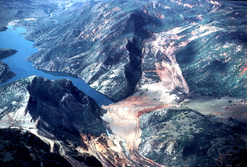
In most places, the western slope of the California coast mountains is steep and largely composed of churned up sedimentary rocks that were scraped off the ocean floor as the Pacific plate subducted under the North American Plate. That makes for generally unstable geology. Originally Posted by Meadow Skipper
The Thistle Slide is pretty famous in the world of landside geology. It was a slow-moving slide, but destroyed the town of Thistle, dammed the Spanish Fork River creating a 3-mile long, 200-foot deep lake, and closed two major highways for 8 months and a major rail line for 3 months. Direct and indirect costs were estimated around $1 billion (2018 dollars)
https://en.wikipedia.org/wiki/Thistle,_Utah#Landslide
Note the new cuts for the highway and rail-re-routes on lower-left. Massive earthmoving effort.
-
01-12-2018, 12:31 PM #37
yelgatgab
- Join Date
- Oct 2002
- Location
- Shadynasty's Jazz Club
- Posts
- 10,323
Is that the one you see on the way to Moab from SLC?
Edit: Just looked at the Wiki link. That's gotta be it. I'd always wanted to research that, but never remembered once I got home. It's knew it must have been a big one, but didn't realize it did that much damage.Remind me. We'll send him a red cap and a Speedo.
-
01-12-2018, 12:37 PM #38
 Registered User
- Join Date
- Sep 2009
- Location
- PNW -> MSO
- Posts
- 8,278
That's pretty fucking stupid. Originally Posted by plugboots
Edit:
So is this the general landslide thread, now? So fascinating.
I'm fond of the Quake Lake area of SW Montana. Magnitude 7.3-7.5 quake in 1959, tied with San Fran for the second strongest in North America after the great Alaska quake.
50 million ranges of material 😁 broke off the mountain and blocked the Madison river, forming the lake that still exists. Being out in the lake is eerie, since many trees are still standing with their tops just above (or just below) the lake surface. Good backcountry skiing, whitewater boating, hiking, etc in the area. Lots of griz, too. The lake level is slowly dropping as the river cuts through the debris.


-
01-12-2018, 12:44 PM #39
A bitter little fruit
- Join Date
- Nov 2002
- Location
- EWA
- Posts
- 23,087
Maybe he's speaking to this: Originally Posted by Norseman
The Columbia Plateau, also known as the Columbia Basalt Plain, is the prominent geographic feature of the interior Columbia River Basin. The plateau formed between 6 million and 16 million years ago as the result of successive flows of basalt. Its northern border is marked by the Columbia River and the mouth of the Okanagon River. On the south, the plain includes the drainage of the Deschutes River in Oregon. On the east the plateau includes the Camas Prairie of central Idaho, and on the west it runs to the foothills of the Cascade Mountains. The Columbia River makes a looping S-curve through the central Washington part of the Columbia Plateau.
In a river basin that is mostly mountains and steep valleys, the Columbia Plateau is an area of flat land and gently rolling hills cut by the sometimes steep river canyons of the Columbia and its tributaries. It is a roughly triangular-shaped area about 250 miles on a side. On its fringes the elevation of the plateau is about 4,000 feet (1,219 meters) above sea level, and at its lowest point it is about 400 feet (122 meters). The Columbia Plateau is the major agricultural region of the interior Columbia River Basin and includes the cities of Ellensburg, Wenatchee, Yakima, Moses Lake, Walla Walla, Pullman, and the Tri-Cities of Washington (Pasco, Kennewick, Richland); Pendleton, Umatilla, and The Dalles, Oregon; and Moscow and Lewiston, Idaho.
The journals of Lewis and Clark briefly note the Plateau. On Sept. 18, 1805, Clark wrote: “...from the top of a high part of the mountains…I had a view of an emence Plain and leavel country to the SW. & West.” After their difficult crossing of the Bitterroot Mountains, the sight of the plain “greatly relieved the spirits of the party,” he wrote in the journals for the next day.“When you see something that is not right, not just, not fair, you have a moral obligation to say something. To do something." Rep. John Lewis
Kindness is a bridge between all people
Dunkin’ Donuts Worker Dances With Customer Who Has Autism
-
01-12-2018, 01:16 PM #40
 Registered Lurker
- Join Date
- Oct 2006
- Location
- Bellevue
- Posts
- 7,542
For more landslide nerdery check out the landslide blog https://blogs.agu.org/landslideblog/
There's a post about rattlesnake ridge https://blogs.agu.org/landslideblog/...snake-ridge-1/
-
01-12-2018, 01:19 PM #41
Registered User
- Join Date
- Sep 2009
- Location
- PNW -> MSO
- Posts
- 8,278
Excellent. Thanks Abe
-
01-12-2018, 01:28 PM #42
Cat. Tastes like chicken
- Join Date
- Aug 2007
- Location
- Bottom feeding
- Posts
- 11,769
Without a doubt, the make up of the underlying strata is different in the two areas. Duh. He should have left it at that, and moved on.Maybe he's speaking to this:Well maybe I'm the faggot America
I'm not a part of a redneck agenda
-
01-12-2018, 01:33 PM #43
Registered User
- Join Date
- Oct 2003
- Location
- slc
- Posts
- 19,240
Yeah, just north of the US-6/US-89 junction on your way up Soldier Summit. Originally Posted by bagtagley
In the grand scheme of things, the largest landslides in modern history are nothing.
The Mt. Shasta megaslide is insane. See the bumpy hills in the photo below? All landslide debris that traveled as far as 30 miles.

Topo. Blocks of slide debris are yellow. Contour lines on the blocks are 50 meters

There have been huge landslides in the Hawaiian Islands that would have created massive tsunamis. All volcanic islands do this. Tsunamis this size could cause Lituya Bay-level destruction (http://www.drgeorgepc.com/Tsunami1958LituyaB.html) along the entire coast of a continent. 2004 SE Asian or 2011 Japan tsunamis would pale in comparison.

-
01-12-2018, 01:46 PM #44
Cat. Tastes like chicken
- Join Date
- Aug 2007
- Location
- Bottom feeding
- Posts
- 11,769
Thanks Dan, great reading.
Well maybe I'm the faggot America
I'm not a part of a redneck agenda
-
01-12-2018, 01:50 PM #45
Registered User
- Join Date
- Mar 2008
- Location
- northern BC
- Posts
- 33,982
The "Hope" slide in BC was a big one, you can drive thru it on hwy 3 headed to Penticton. You can see where the MTN let go on lookers left , swept across the valley and right up the the other side on lookers right but it was only 41 million tons whereas the Frank was 78million
Lee Lau - xxx-er is the laziest Asian canuck I know
-
01-12-2018, 04:11 PM #46
 Not on IR. For now.
- Join Date
- Jun 2006
- Location
- Couloirfornia
- Posts
- 8,874
Here's a smaller manmade one:
https://en.wikipedia.org/wiki/Aberfan
So tragic. Originally Posted by Ernest_Hemingway
-
01-12-2018, 04:22 PM #47
Funky But Chic
- Join Date
- Sep 2001
- Location
- The Cone of Uncertainty
- Posts
- 49,304
Gonna be a lot to talk about in this thread in the near future when this shit goes off: https://www.newyorker.com/magazine/2...really-big-one
wtf are you people doing, living there? Shit is overfuckindue. And it's gonna be grim.
It's like if we on the East Coast had 300 years to get out of the way of a massive hurricane and we decided we're fine with it, we're staying right the fuck here. But we're not really gonna prepare at all. What?
-
01-12-2018, 04:52 PM #48
Registered User
- Join Date
- Aug 2007
- Location
- United States of Aburdistan
- Posts
- 7,276
Article says they started to figure this out in the late 80's and early 90s. I get your point though. Originally Posted by iceman
-
01-12-2018, 05:00 PM #49
 Vagitarian
- Join Date
- May 2002
- Location
- Halfway Between the Gutter and the Stars
- Posts
- 3,857
and telling the people they're stupid for living there. Originally Posted by old goat
You are what you eat.
---------------------------------------------------
There's no such thing as bad snow, just shitty skiers.
-
01-12-2018, 05:05 PM #50
Funky But Chic
- Join Date
- Sep 2001
- Location
- The Cone of Uncertainty
- Posts
- 49,304
I hear you. It's like we had 30 years to get ready for a storm, not 300. Seems like enough? Should be adequate warning? Who knows. Originally Posted by muted

 Reply With Quote
Bookmarks