
Are there any decent glaciers to ski on in the backcountry there?
Anyone been backpacking there have any suggestions about the area?
Results 1 to 25 of 26
Thread: Bighorn Mountains
-
06-24-2005, 07:05 PM #1

 Registered User
- Join Date
- Jun 2004
- Location
- Sacramento, CA
- Posts
- 1,084
Bighorn Mountains
-
06-24-2005, 07:59 PM #2
 A very naughty rodent
- Join Date
- Oct 2003
- Location
- 写道
- Posts
- 13,605
I was there back in 96 and don't remember any glaciers. Don't they only top out at around 9-10K. Possibly some year-round snowfields.
Your dog just ate an avocado!
-
06-24-2005, 08:06 PM #3
 13,175 ft.

- Join Date
- Apr 2005
- Posts
- 573
The highest point is 13167 ft.
-
06-25-2005, 12:20 PM #4
Registered User
- Join Date
- Jun 2004
- Location
- Sacramento, CA
- Posts
- 1,084
There are many peaks at or around 13k and there have been reports of some of the areas getting over a foot of snow in the first week of september. Seems cold enough to me.
Cloundpeak, why don't you know more about the area? Are you a local or did you just steal that name?
-
06-25-2005, 11:26 PM #5
13,175 ft.
- Join Date
- Apr 2005
- Posts
- 573
Actually, I know quite a bit about the area. I grew up there and the family's been in the area for a couple of generations. Originally Posted by wanghoeby
Cloud Peak is the tallest peak in the Big Horn range. Some (like the Forest Service) say it's 13167 ft. Others claim it's 13,175 ft. Take your pick. If you're looking for a glacier, you'll find the last remaining one in this range on the east side of Cloud Peak itself.
You can climb one side of Cloud Peak without technical rock climbing skills. The last bit requires some scrambling, though. To get to this route, hike in from the Misty Moon trailhead. To get there, take US 16 to Deer Haven Lodge where you'll turn on Forest Service Road #27. It's gravel and likely to have a washboard surface. Next, you'll take the Misty Moon Trail to the junction with the Solitude Trail at Misty Moon Lake. (Misty Moon Lake is a very pretty high alpine lake.) At the junction you'll find a trail called Paint Rock Creek that goes along a ridge to the peak. It goes over boulders, along a thin ridge, and requires scrambling. People also climb Black Tooth and Woolsey, but I think these require technical skills. Some of the peaks to the south, Big Horn and Darton, are lower elevation, but require even more scrambling than Cloud Peak.
For backpacking, I'd recommend much the same route you would take to climb Cloud Peak. Misty Moon's a lovely little lake. Also, a hike to Lake Angeline is well worth the effort. The Solitude Trail takes you over Florence Pass, which is a favorite of mine even I hear it can be crowded these days. The Solitude Trail lets you circumnavigate Cloud Peak Wilderness. This trail is about 53 miles long. You can take shorter hikes by choosing any number of lovely paths off the Solitude hike that will take you to pretty lakes. By the way, you also can access Florence Pass by coming in through the Hunter Corral trailhead off US 16. This entrance has a long jeep trail at the beginning of the trail, which I find rather unappealing.
If you enjoy rock climbing, Cloud Peak Wilderness and the peak itself offer opportunities for climbing some nice granite faces. Tensleep Canyon offers the chance to climb limestone cliffs. If you want to climb, you should locate local rock climbers to find the currently popular routes. I'd contact Big Horn Mountain Sports in Sheridan for information. It used to be a good store, and if it's still in business, they can probably help you.
Pros and Cons of this area:
Pros - The scenery is beautiful. It sports high alpine meadows and lovely little lakes. The Big Horns have some of the best wild flowers anywhere. You can also see moose, elk, deer, and black bears. Lots of cougars live there, but you probably won't see them. The place also has ample bird watching opportunities. People love to fish for trout in the lakes and streams (be sure to get a WY fishing license), and some of the lakes have the famed golden trout.
Cons - The area has horse pack trains, and before you enter the wilderness, you might encounter some off road vehicles. Unfortunately, many outfitters use this area for horse packing and allow their animals to graze on the fragile alpine flora. These pack trains can make for dusty and crowded trails and sometimes campsites, too. If you use topo maps, you can avoid some of the crowds. While in the area, you'll need to watch your weather carefully. Often in the summertime, you'll be rewarded with sunny, warm days. But weather here can change quickly, and you can experience snow, wind, rain, and thunderstorms at any time.
I'm unaware of whether anyone skis the glacier. For more information, I would contact the store in Sheridan that I mentioned and/or the Forest Service.
Hope this helps...
CP
-
06-26-2005, 12:00 PM #6
 Dirty Old Man
- Join Date
- Jun 2005
- Location
- Denver
- Posts
- 2,054
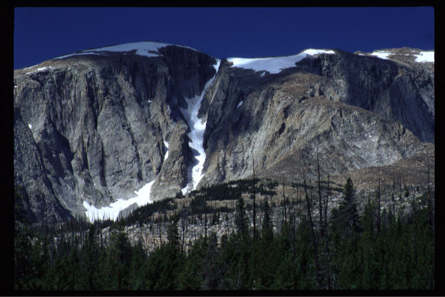
There's a few glaciers near cloud peak. The glaciers are all on the east side and the best access is from the southwest. Also Bighorn Peak has a super sweet couloir. Not sure how long it holds snow
See the pics and the link to summit post
http://www.summitpost.org/show/mount...mountain_id/67
Cloud Peak East Cirque w/Glacier There are 2 Couloirs Here that are skiable

Bighorn Peak, Not sure how long this hold snow. Check topozone for access
-
06-26-2005, 05:41 PM #7
Registered User
- Join Date
- Jun 2004
- Location
- Sacramento, CA
- Posts
- 1,084
Thanks CP for the info it's very helpful. I'm just trying to avoid crowds and have a good time away, with the rest of my family. I've heard many people say that clound peak etc. is a very nice area... how busy is it? I'll be there August 14-19 so I don't think there is too much of a chance of snow being there, atleast not enough that I'd bring my skis along with me for a 50 mile trek.
-
06-26-2005, 08:59 PM #8
 Registered User
- Join Date
- Sep 2002
- Location
- MT
- Posts
- 1,368
Snoop around Bomber mtn, you just might find something.
My Montana has an East Infection
-
06-26-2005, 11:38 PM #9
13,175 ft.
- Join Date
- Apr 2005
- Posts
- 573
Wanghoeby,
In August, the weather should be nice and the wildflowers should still be blooming at the higher elevations.
As for crowds, I hear that outfitters run a lot of horse trains into the area these days. So expect the main trails to be crowded and dusty. By using topos, though, you should be able to find uncrowded camping spots, as the wilderness does not require designated campsites.
The weather can be variable. Plan for thunderstorms, hail, rain, and maybe even a little snow. Unless a storm moves in, though, daytime temps should be in the 60s. Nighttime can still be chilly.
In August, the bugs should have started to die down a bit, but I'd still bring bug goop.
Just a side note...they don't allow campfires above 9,200 ft., which is fine with me because I always use a stove anyway.
You can hike up Bomber Mountain and, as Mountainman suggested, perhaps ski off it. Personally, though, I've never skied in this wilderness area and can't give you guidance about that. The hike up that peak will take about 2 hours. Many people enjoy it for the views and because a plane crashed there in 1943. You can still find remnants of it.
As I alluded in my previous post, I would definitely climb Cloud Peak. It's a walk up and offers lovely views.
The 53-mile hike, Solitude Trail, goes all the way around the wilderness. You're under no obligation to do the entire loop. You can set a base camp and do day hikes to various lakes and peaks. Please note that you'll encounter additional mileage, though, to get to the wilderness boundary.
-
06-26-2005, 11:39 PM #10
Dirty Old Man
- Join Date
- Jun 2005
- Location
- Denver
- Posts
- 2,054
Here's at topo. look at all the snowfields, these are permanent
I would bring my skis for sure
-
06-27-2005, 06:26 AM #11
Registered User
- Join Date
- Sep 2002
- Location
- MT
- Posts
- 1,368
I was more suggesting that he look for the plane, pretty sweet to find. Although a lot of stuff has been taken since when my dad and his brothers would hike there when they were kids.
My Montana has an East Infection
-
06-27-2005, 10:12 AM #12
A very naughty rodent
- Join Date
- Oct 2003
- Location
- 写道
- Posts
- 13,605
Nice stuff, Cloudpeak. There's so much there that I never saw. I was in the Big horns in mid june of 96, supposedly a big snow year and, so the race I did avoided the high country. I remember the wild flowers as I decended into (what I think was) Tongue River Canyon. I also recall the thunderstorms that would hit, seemingly like clockwork, around 3 or 4 PM, then end yield some incredible sunsets. I also remember seeing the biggest fuckin' rattlesnakes ever- much bigger than their desert brethern.
Watching the "Mosquito Truck" meander the streets of Sheriden at night was of particular interest, too.Your dog just ate an avocado!
-
06-27-2005, 01:09 PM #13
Registered User
- Join Date
- Jun 2004
- Location
- Sacramento, CA
- Posts
- 1,084
This line would be flipping sweet to do in may or june. It looks like it might be a little rocky in august.
Originally Posted by KillingCokes
Any one have any maps of the area that they are not using any more? I've looked all over the internet and can't find any trailmaps. The USFS site doesn't work for some reason on my computer.
-
06-27-2005, 06:37 PM #14
Dirty Old Man
- Join Date
- Jun 2005
- Location
- Denver
- Posts
- 2,054
Any one have any maps of the area that they are not using any more? I've looked all over the internet and can't find any trailmaps. The USFS site doesn't work for some reason on my computer.[/QUOTE]
http://www.topozone.com/viewmaps.asp
Type in the exact name of wherever you need to go and you can get anysize topo of the area. Thats where i got the cloud peak map. Click on the map to move center
-
06-30-2005, 03:25 PM #15
Registered User
- Join Date
- Jun 2004
- Location
- Sacramento, CA
- Posts
- 1,084
That site's sweet. So if I were to make the cloud peak loop or what ever it is that I keep hearing about, how many people would I see? Is it like back country in the grand tetons? or is it much less traveled?
-
06-30-2005, 05:10 PM #16
13,175 ft.
- Join Date
- Apr 2005
- Posts
- 573
If you hike the Solitude Trail (that's the loop), you'll definitely encounter other people. Outfitters take many people in on horse pack trains these days. Solitude (ironic name, eh?), though somewhat crowded, offers many opportunities for side hikes where you'll see fewer people. Even with other people around, Cloud Peak Wilderness has amazing scenery and high alpine meadows. Most of your hiking occurs at 10,000 ft. and above. Originally Posted by wanghoeby
-
11-15-2005, 11:39 AM #17
Registered User
- Join Date
- Nov 2005
- Posts
- 4
winter ascents
Anyone do these couloirs in the winter? I'm thinking about a trip (from Minnesota) this winter sometime.
Steve
-
11-15-2005, 01:40 PM #18
 Registered User
- Join Date
- Sep 2001
- Posts
- 563
My only advice, is to avoid Greybull at all costs.
-
11-15-2005, 02:22 PM #19
Registered User
- Join Date
- Jun 2004
- Location
- Sacramento, CA
- Posts
- 1,084
When are you thinking about going?
-
11-15-2005, 04:44 PM #20
Registered User
- Join Date
- Nov 2005
- Posts
- 4
Couloirs
I was thinking about going in March, but I could go anytime after Jan. 1. Depends on conditions I suppose. I'd welcome company, esp. someone who knows something about the area. But I'm happy to thrash about with people who know as little as I do.
-
11-15-2005, 05:23 PM #21
Registered User
- Join Date
- Jun 2004
- Location
- Sacramento, CA
- Posts
- 1,084
If you were going spring break I'd consider it. I was there backpacking for 7 days in the summer, so I know the area. Never been BC skiing or mountaineering, but I was planning on learning this year.
Last edited by wanghoeby; 11-15-2005 at 05:25 PM.
-
11-15-2005, 08:10 PM #22
Registered User
- Join Date
- Sep 2002
- Location
- MT
- Posts
- 1,368
7 days and ya got the area mapped. Good job i must say. Originally Posted by wanghoeby
My Montana has an East Infection
-
11-16-2005, 03:10 AM #23
Dirty Old Man
- Join Date
- Jun 2005
- Location
- Denver
- Posts
- 2,054
Originally Posted by Stefanohatari
This sounds very foolish. Get alot of experience before you trek off into a continental snow pack in winter conditions. Until you can dig multiple snowpits and understand what you see please don't go, I really don't want to read about the two missing flatlanders in the bighorns. Avalanche 1 and 2 would be advised as well as wilderness 1st responder. a week of lower angled recon to get get an idea of the snowpack wouldn't be a bad idea as well. Did you factor into your trip the need for acclimitization. You won't have the energy to carry 40-60lbs into the goods without spending time letting your body adjust to 20% less O2. Originally Posted by wanghoeby
Every year in Colorado newbies die in the backcountry. The bighorns have a very similar snow pack to Colorado. They see the inviting slopes and the nice powder and don't understand the dangers hiding in the snow. How fast can you find a beacon in the snow? If you don't get to him within 5 minutes his chance of death is about 90%. How will you get an injured man 7 miles out of the wilderness, by yourself. It's not like the movies where there's a crew of 20 people trained in rescue waiting for the shit to hit the fan.
Here's alink to the avalanche accidents in the US and Colorado for the last 10 years. Read it and learn what you can.
http://geosurvey.state.co.us/avalanc....aspx?tabid=31
The time to go on this trip is the spring. Get an early start from a high camp. Early means 3-5 am Climb your couloir on frozen ice crust and wait at the top for it to thaw. Ski the corned couloir and go back to camp. Off the steeps by 10-11 am. Bring your fly rod and catch dinner. I'm planning a trip up there myself next year in May or June.
-
11-16-2005, 08:47 AM #24
Registered User
- Join Date
- Nov 2005
- Posts
- 4
Good Advice KillingCoke
But just so you don't worry--it's the area I'm new to, not mountaineering. I'm a cautious 47-year-old, though I guess 'cautious' is relative.
-
11-19-2005, 05:49 PM #25
Registered User
- Join Date
- Jun 2004
- Location
- Sacramento, CA
- Posts
- 1,084
Bighorn Mountains TR
Here is my TR on a trip that I took into these mountains with my dad and brother in mid August this past summer. We made the standard Solitude Trail loop and with everything totaled up we did almost 70 miles in 7 days and 6 nights and I think 4 or 5 times we went above 10K feet and back down. The terain there was something else. All of the horses nicely erode all of the dirt away so that you are left with large granite rocks and extremely rough trails. Nonetheless it was very unpopulated and many of the people out there are very serious about what they do.
This was Highland Park. Hoooooly crap was this an awesome place. It was this big flat bowl of grasses and small trees at roughly 10K feet. The Bighorn range was right in front of your nose and you were surrounded by mountains on nearly 180 degrees. About two hours after this we made a critical error that caused us to travel an extra 5 miles off course. When we started heading back a group of fishers took our gear in their pick up and we saved walking with our packs on for roughly 3 miles. It turned out to be great, because the guys were nice enough to give us all a beer back at camp. God that tasted soooo good.

My dad and I high above Lake Solitude. There was a 500 ft drop just to the left of this picture, and it was fairly windy. Yikes.

Sunset at one of our campsites.

There was not a whole lot of flowers in bloom when we were there, had to go to higher altitude to find them. This was just under Geneva pass.

Florence Lake/Pass. There was actually some snow up here, but it was windy as hell. Could see I-90 from the top.

Early sunrise on our last day in the mountains. This site is the most perfect location to camp, hands down. You were on this ledge that was looking over the entire valley. It dropped off right at the edge of the site to expose thosands of acres including the river that was near by.

Give my dad a break, it was his birthday. Although I'm pretty sure that waking up to that sunrise in those mountains can't get much better for a birthday present. The previous night me and my brother did a scramble up the lower slopes of this peak, though it got dark and cold real fast so we never got real high up.

The sunrise was way too majestic to explain with words.

Here's looking up the valley we just came out of.

Oh yeah, this is what I hiked 5 out of the 7 days in. My new boots although okay for day hikes ripped the shit out of my feet when wearing them for 8 hours per day. Actually the sandals worked out really nicely and I would consider wearing the same setup again, it actually was quite comfy.

I would highly recommend these mountains to anyone. Except, unless you are really really fit, I'd just plan a trip going up into the mountains and then back down and not try the whole loop your first time out there. You could probably count the groups of people you see on your entire trip with one hand. I'm definetly going back there, to climb Cloud Peak, which I never got to do because of our busy schedule.Last edited by wanghoeby; 11-19-2005 at 05:57 PM.

 Reply With Quote
Bookmarks