
This is a thread to discuss the uncommon, interesting and possibly historic avalanche cycles in the Central/Northern Sierra Nevada (specifically Tahoe but also including other regions of the range that are similarly affected) occurring in January 2017, and possibly further out into the season.
As of 1/6, we are in the midst of a series of continuous atomospheric river events, some of which have been forecasted to deposit double-digit inches of SWE, following an early season which formed both basal facets on north faces and also crust-facet complexes on most aspects other than due south.
I'll do my best to update this post into an ongoing summary of the avalanche cycles and snowpack history as things develop, but I'm really busy so we'll see how this goes. I invite any input - on the accuracy of my commentary, and also on notable events or obs that should be worth including in this post. I've also not yet included any ESAC, Bridgeport or other links but if anything is notable, please call it out as such and share!
Current Happenings: (1/6/2017)
-Forecast ahead predicts an AR event consisting of 7-15" of SWE for the period from Friday night 1/6 through Monday 1/9, with periods of very heavy rain (several inches) forecasted to 9500' on Sunday. With no break, another AR comes in on Tuesday 1/10, with 4+" of SWE forecasted with snow levels anywhere from 4000 to 7000 feet (below pass elevations). Unsettled weather is forecast to continue through the week ... all of this meaning avalanche activity very likely to continue all through next week.
-This week so far has been very interesting ... On Thursday 1/5, a skier group with two dogs triggered a deep slab in the Mount Rose wilderness area ("Fireplug" slide path). It appeared to be nearly a full path slide, and a very impressive slab with up to 6' crown height, and a rain crust layer appared to actually part of the slab itself.
Incident Report: http://www.sierraavalanchecenter.org...anche-fireplug
Party's Account of Incident: http://www.sierraavalanchecenter.org...anche-fireplug
Video showing crown (vid from SAC):
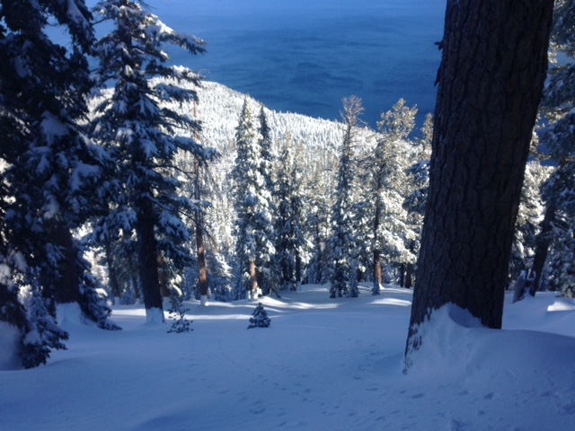
Image of skier tracks (img from Eastern Sierra Skier):
-The skier triggered slide was preceded Wednesday 1/4 (estimate) by natural deep persistent slab avalanches likely to have occurred during or at the tailing end of new precipitation from Monday 1/2 through Wednesday 1/4. The unique quality of these natural avalanches is that they occurred at lower elevations and well below treeline, which is not common for the region. These areas linked below are regular "go to" terrain for a lot of local skiers, including during heightened danger conditions.
-Jakes Peak gully, mid-elevation but well below treeline, 5' crown height, very long track: http://www.sierraavalanchecenter.org...hes-jakes-peak
(note, this image of the bed surface and surrounding view is similar to terrain many Tahoe skiers would consider "on the table" for heightened danger days, img from SAC)
-Silver Peak approach, near treeline but at relatively low elevation (img from SAC): http://www.sierraavalanchecenter.org...es-silver-peak
-A natural avalanche was also rumored on Slide Mountain at Mt. Rose Highway.
-Wednesday 1/4 through Friday 1/6 also saw a lot of impressive control work results - crowns of up to 15' in some cases - in ski resorts with large alpine terrain areas, such as Squaw Valley, Kirkwood, and Mammoth. Thursday 1/5 or Friday 1/6, Kirkwood Mountain Resort Patrol triggered a impressive windslab avalanches above treeline, some with what appear to be 15' crown heights.
-Specifically at Mammoth Mountain, a face had been subjected to 40# artillery shells without results, then later bombed with single hand charge that produced an extremely large slide to November raincrust with 12' max crown height: http://esavalanche.org/content/mammo...patrol-results
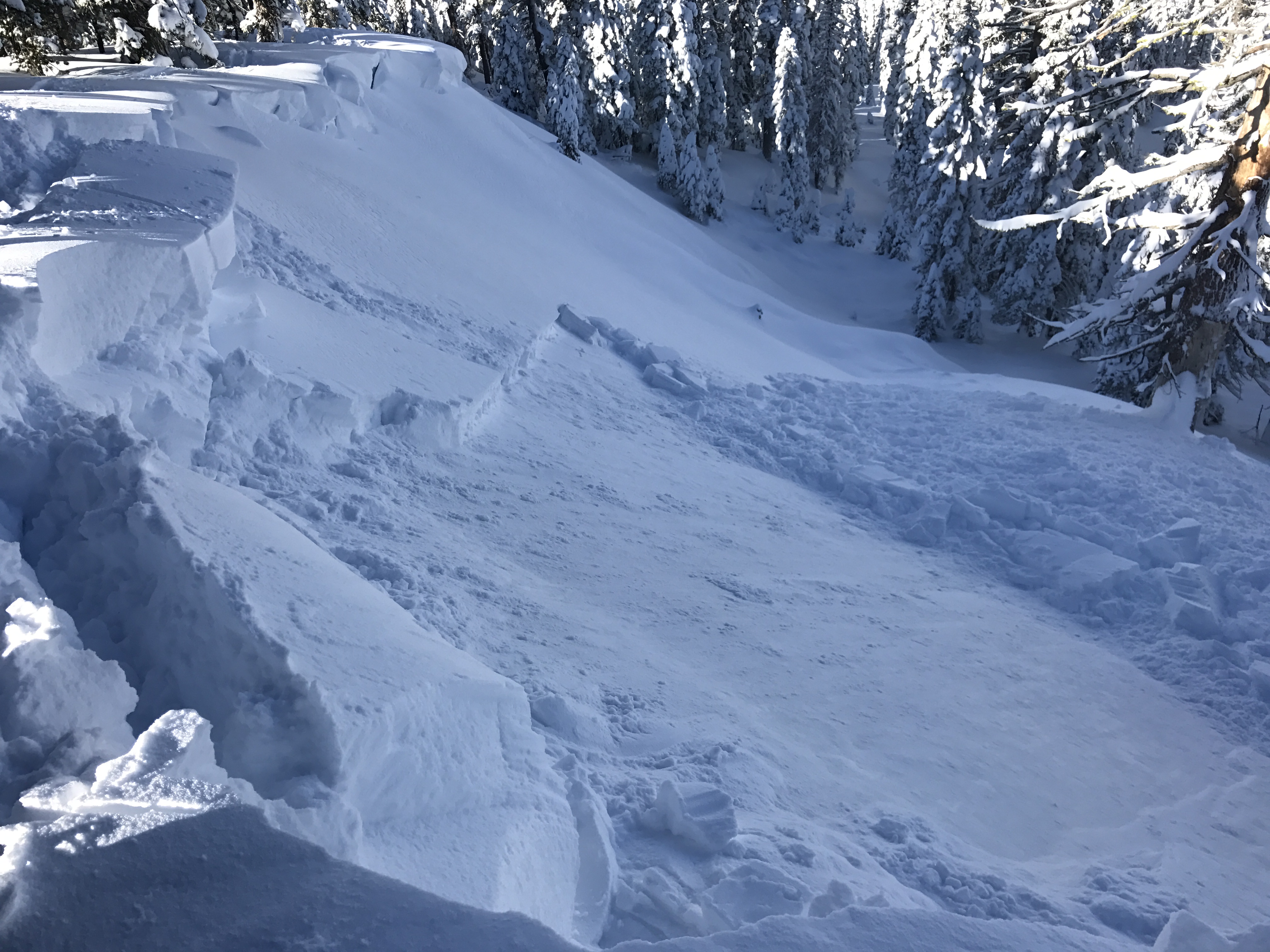
Kirkwood Backside (Wave?) at Thimble Peak (this is a lee facing area above treeline, on the ridge of the Sierra Crest, img uncredited):
Mammoth Mountain Ski Area
Squaw Valley Siberia Bowl (img uncredited):
Squaw Valley KT22 Debris (img uncredited):
-A cohesive snow slab consisting of several inches SWE, 100 to 180+ cm in depth, (deposited by an atmospheric river on 1/2 through 1/4) has developed on top of a crust/facet complex of multiple layers formed from high elevation rain crusts (up to 10K in Tahoe, 11k in Eastside) intermixed with small amounts of snow. The crust/facet layers were formed from 12/8 through 12/17. Fluctuating temperatures during this period created very interesting layers of wet snow and crusts. Immediately following development of these crusts, natural and skier triggered avalanche activity had been observed on both the 12/9 and 12/15 raincrusts as the bed surface. It is particularly interesting to me that the Fireplug slide appeared to have NCF between the two raincrusts as the failure layer with the 12/15 crust as part of the slab!
-Selected Obs reports from 12/9 through 12/15 that detail the formation of the crust-facet complex currently below the overlying slab:
12/8: http://www.sierraavalanchecenter.org...mps-blue-lakes
12/9: http://www.sierraavalanchecenter.org...t-stevens-peak
12/15: http://www.sierraavalanchecenter.org...800-relay-peak
12/16: http://www.sierraavalanchecenter.org...k-observations
-In mid December, basal facets on north faces had been a layer of concern, active in multiple skier triggered and natural avalanches occurring 12/10 through 12/16 at the ground. However, since the most recent heavy precipitation, we have not seen activity on this layer, and it's unclear if this layer still has potential to fail again under the next series of AR/precip events or if it continues to gain strength from warm temperatures and weight load/settlement.
12/10 Mt. Rose Skier Triggered Avalanche: http://www.sierraavalanchecenter.org...mt-rose-chutes
12/10 Carson Pass Natural Avalanche: http://www.sierraavalanchecenter.org...ephants-back-1
Results 1 to 25 of 80
-
01-06-2017, 03:03 PM #1

 Wax on, scrape off ...
- Join Date
- Mar 2007
- Location
- Eugenio Oregón
- Posts
- 8,858
Central/Northern Sierra Nevada, January 2017 Avalanche Cycles
Last edited by SchralphMacchio; 01-08-2017 at 04:50 PM.
_______________________________________________
"Strapping myself to a sitski built with 30lb of metal and fibreglass then trying to water ski in it sounds like a stupid idea to me.
I'll be there." ... Andy Campbell
-
01-06-2017, 03:54 PM #2
 Expert Jong
- Join Date
- May 2011
- Location
- Truckee & Nor Cal
- Posts
- 16,402
Not that we can't discuss it in the Tahoe thread, but I like the idea of a separate snowpack thread that gets a bit more in-depth. So late Saturday - Monday morning... let's hope all of that rain does just enough to wipe out those shitty layers without wiping out the entire snowpack. I'm not optimistic.
Really hoping nothing bad comes out of today. Seems like the day it would happen.
-
01-06-2017, 05:13 PM #3
 Not on IR. For now.
- Join Date
- Jun 2006
- Location
- Couloirfornia
- Posts
- 8,874
I'm optimistic for what the snowpack looks like by mid- to late next week. What layers are there by next weekend is going to be the most interesting part. Originally Posted by TahoeJ

And, yeah, definitely curious to see if there are any incidents today. Fingers crossed people watch it. Originally Posted by Ernest_Hemingway
-
01-06-2017, 10:00 PM #4
 Looking 4 fresh en France
- Join Date
- Sep 2006
- Location
- Marin born -> Chico State -> CH -> France -> Truckee
- Posts
- 470
Yea its a wait and see at this point. Some rain may very well help us out. One thing to note is that the burried weak layers are DEEP. Ski resorts such as squaw are exerting massive forces on the slopes using their control techniques. While it proves the potential for those large scale slides it is also unrealistic to have those forces exerted on a slope in the backcountry by skiers/boarders. Probably why SAC has frequently ranked the likelihood of a slide on the lower end, but the ranked avalanche size as being possibly historic if it did release.
Im not trying to justify a reason to believe that its safe out there, just something to take into consideration when looking at all the pieces of the puzzle. I think it is a time to be on our toes, in safe terrain, and with our heads on a swivel. What we are dealing with just isn't a common theme in this mountain range.
The last thing ill add, is i predict the possibility of some large natural slides with the onset of rain on saturday. It seems the additional weight of water absorbed in the snowpack could be the "icing on the cake" to get some pretty legit naturals to occur.
Thanks for starting this thread!"Can switching to Geico really save you 15% or more on car insurance?"
"Do people really call 911 thinking they will get seen faster in the ER?"
-
01-06-2017, 10:45 PM #5
 average gaper
- Join Date
- Dec 2006
- Location
- Your Mom's House
- Posts
- 8,431
I realize I'm cutting out the part of your post where you're being more realistic, but.... Originally Posted by jskierpx
Speaking as someone who is far from an expert, but who deals with these sort of problems much more regularly (as a midwinter CO backcountry traveler), the fact that the weak layers are generally buried deep or that large explosives are required for triggering at ski areas IS NOT any indication of stability or your ability to affect said weak layers. Relying on the strength and thickness of the overlying slab (aka "bridging") is a numbers game at best. If you ride on one of those slabs and it doesn't go, it's not because you made a good decision. You got away with it. You got lucky and didn't find the sweet spot. All it takes is finding the one spot on the slope where the slab is a bit thinner and your weight can affect the weak layer and the thing will go. Maybe it's the margins of the slab on top, sides, or bottom; maybe it's a buried rock or tree that you can't see from the surface. The point is, these fuckers are super unpredictable and anyone sufficiently afraid of them will give them a very wide berth until the weak layer heals. Do not fuck with the deep persistent slab.
The part I bolded above is flat out false. YOU CAN AFFECT THE WEAK LAYER. Don't underestimate it.
Here are a few fatal avalanche accidents in CO with large crowns that occurred when the likelihood of a PS or DPS was rated as "Possible"
http://avalanche.state.co.us/caic/ac...=518&accfm=inv
http://avalanche.state.co.us/caic/ac...=531&accfm=inv
http://avalanche.state.co.us/caic/ac...=505&accfm=inv
Note that all of these accidents involved multiple burials and/or experienced parties. The common thread is that all of them underestimated the unpredictability of deep persistent problems. Do not make this mistake.
-
01-06-2017, 11:30 PM #6
Looking 4 fresh en France
- Join Date
- Sep 2006
- Location
- Marin born -> Chico State -> CH -> France -> Truckee
- Posts
- 470
All valid points and I agree. I have no intention of implying that a skier/boarder cannot trigger something catastrophic, as you pointed out spacial variability is the culprit and if you hit the sweet spot it will go. All I was getting at, is when ski patrol puts a 6 pound or 8 pound charge, or a load of ANFO on a slope, it is not the equivalent to me or you skiing on that slope.
The idea with the explosives, of course, is to affect as great of surface area as possible with each charge, to hopefully hit the sweet spot"Can switching to Geico really save you 15% or more on car insurance?"
"Do people really call 911 thinking they will get seen faster in the ER?"
-
01-06-2017, 11:51 PM #7
average gaper
- Join Date
- Dec 2006
- Location
- Your Mom's House
- Posts
- 8,431
No, a 6# or 8# charge is not the same as a skier on the slope, but it is also very much not an indicator of stability or safety. So in that sense it really doesn't matter.
What DOES matter is that 1) you skiing on the slope can affect the weak layer, 2) finding the point where you will affect the weak layer is extremely unpredictable, and 3) if you do trigger a slide the chances of you surviving it are minimal.
This should scare the shit out of you. There is no silver lining. Stop telling yourself false narratives of "well, all the recent slides required big bombs..." because they are irrelevant.
Read this: http://avalanche.state.co.us/the-dan...ing-stability/
-
01-07-2017, 12:13 AM #8
Not on IR. For now.
- Join Date
- Jun 2006
- Location
- Couloirfornia
- Posts
- 8,874
 Originally Posted by Ernest_Hemingway
-
01-07-2017, 09:36 AM #9
Wax on, scrape off ...
- Join Date
- Mar 2007
- Location
- Eugenio Oregón
- Posts
- 8,858
I believe that's from top of the Wave at Kirkwood, I think triggered on Friday 1/6. Approx 9500', above treeline, at the Sierra Crest since there is not much topography west of this point. Originally Posted by LightRanger
_______________________________________________
"Strapping myself to a sitski built with 30lb of metal and fibreglass then trying to water ski in it sounds like a stupid idea to me.
I'll be there." ... Andy Campbell
-
01-07-2017, 10:05 AM #10
Expert Jong
- Join Date
- May 2011
- Location
- Truckee & Nor Cal
- Posts
- 16,402
I think we're going to see that picture for many, many years. I'm sure it's perfectly stable at that point due to the force of such a large slide ripping out and it's probably near the top of the ridge, but I would be nervous even standing there.
-
01-07-2017, 10:44 AM #11
Looking 4 fresh en France
- Join Date
- Sep 2006
- Location
- Marin born -> Chico State -> CH -> France -> Truckee
- Posts
- 470
No need to get worked up. I'm not looking for false positives or reasons to prove we have a stable snowpack. I was trying to imply the opposite actually. My intention was to discuss variables to take into account when looking at our snowpack. Some people see pictures or read an account of a slide and instantly go into historical panic mode. It's worth reading beyond these accounts to have an open discussion. Again as I stated earlier I am currently staying out of avalanche terrain, am uncomfortable with the exposure given the current conditions, but don't think it's unreasonable to talk about possibilities here. But such is the life of forum discussions.
"Can switching to Geico really save you 15% or more on car insurance?"
"Do people really call 911 thinking they will get seen faster in the ER?"
-
01-07-2017, 12:27 PM #12
Wax on, scrape off ...
- Join Date
- Mar 2007
- Location
- Eugenio Oregón
- Posts
- 8,858
I get your point jskier, but as your word choice is easily mistaken for a sentiment that it's possible to ski safely. I guess the key is that skiing without incident, under this problem, is not the same as skiing safely.
Also, do you think those 2 skiers on Fireplug exerted the same force as a bomb? Therefore it's not unrealistic. This layer is also so deep I'm not sure if the dogs (with deeper penetration of force) would have made a difference in that Fireplug slide._______________________________________________
"Strapping myself to a sitski built with 30lb of metal and fibreglass then trying to water ski in it sounds like a stupid idea to me.
I'll be there." ... Andy Campbell
-
01-07-2017, 01:07 PM #13
 Foredeck
- Join Date
- Feb 2009
- Location
- NorCal
- Posts
- 996
That crown is from the Wave, saw it yesterday. Ran big and took out some trees.
Has anyone seen the skiers account of the fireplug slide and rescue? All I can find is the SAC forecaster post mortem.
-
01-07-2017, 01:31 PM #14
Wax on, scrape off ...
- Join Date
- Mar 2007
- Location
- Eugenio Oregón
- Posts
- 8,858
To the couple involved in the Fireplug accident or any of their friends:
* Thank you very much for posting your account of your accident on the Sierra Avalanche Center site. It takes a lot of courage, and I am sure that it was an incredibly emotionally straining event. I was involved in a similar accident with fatal outcome 3 years ago, so I have a sense what you are going through. If you want to talk with someone who has been in the same boat - about anything, to vent, to learn, to share, to talk about the avy bulletin format, whatever - I can be found on Facebook, and Andy Anderson at SAC knows how to get a hold of me ... my name is Alex Do.
Their account is here:
http://www.sierraavalanchecenter.org...anche-fireplug
... by the time we arrived it appeared that several people had skied Hourglass ... ski tour up to the ridge above fireplug and if the snow pit looked good we would ski it ... everything felt very stable , no whomphing and probing the snow with the ski pole showed no obvious weak layers in the new snow ... I didn't dig all the way to the ground, but I dug past the Dec. 15 ice crust by about a foot. The pack was surprisingly stable ... I could not get anything further down to release at all. Also, snow density was very consistent throughout the pack ... With this in mind we decided to ski it ... She was approximately 3/4 of the way down when she dissappeared from view. I gave her a minute to get to our safe point and began my descent ... I noticed a crack in the snowpack, then immediately saw the crown ... I switched over to search and began a beacon search of the debris field ... She was fully burried 3-4 feet deep. I found her head immediatley and found her to be breathing, but very lethargic borderline unconscious. After a few minutes of being in the open air she came around and complained only of knee pain ... we are very fortunate.
This account shows a lot of the challenges of tactics (using pit data, exposing 1 person on the slope, communication, etc) vs. strategy (terrain selection and certainty of managing the most likely problem vs. the worst problem) when dealing with a persistent slab or deep persistent slab problem.
My friend TahoeBC has a quote that illustrates the challenges of dealing with a problem like this:
The real question is, what is the certainty of whether the problem exists here ... and if it does, are we willing to rely on bridging or strength to make up for a problem of underlying structure? If a 4-10' slab fails, even a small isolated slab, can we manage it at this location? Are we on an anchored low angle slope? Are we exposed to any overhead danger? Is this exposure acceptable for this problem? These are not easy questions to ask when in familiar territory with lots of other people and tracks out, with no results. Originally Posted by TahoeBC
Challenging problem for sure.Last edited by SchralphMacchio; 01-07-2017 at 02:15 PM.
_______________________________________________
"Strapping myself to a sitski built with 30lb of metal and fibreglass then trying to water ski in it sounds like a stupid idea to me.
I'll be there." ... Andy Campbell
-
01-07-2017, 03:05 PM #15
Registered User
- Join Date
- Sep 2016
- Posts
- 141
A few comments:
1a) Adrenalated makes some hugely important points...The Mammoth Mountain results from the past few days clearly indicate that hitting the sweet spot on a slope with less force (order(s) of magnitude less?) can generate catastrophic results that military weapons (40 lb warhead) could not produce. I believe that the skier versus bombing argument will only lead to incorrect assessments, particularly in scenarios where deep failure propagation across a large area is at the peak of concern.
1b) In AIARE III, we spent a good bit of time probing the alpine to look for shallow regions across larger hazard areas that could serve as examples of these sensitive failure locations that would act to allow failure (collapse) and propagation of the failure across the slope. There are many, and these are what you don't want to find yourself!
2) The current avalanche cycle (and the Mt Rose avalanche incident/cycle) have many characteristics highlighted during large widespread avalanche cycles in the western US discussed in a paper that is currently in revision for the Journal of Hydrometeorology. I presented preliminary results at the International Atmospheric Rivers conference this August. The presentation can be found here. Summary: Early storms followed by dry, cold weather and low solar insolation and subsequent significant precipitation/loading (often due to ARs) are a grand recipe for massive avalanche cycles.
3) The Upside Down V (aka Fireplug) is one of the most non-textbook classic paths in the Rose region and such results are completely unsurprising. Good on the people for reporting their story, but the amount of mistakes they made are quite shocking. Very lucky outcome for a variety of obvious reasons.
-
01-07-2017, 03:37 PM #16
Foredeck
- Join Date
- Feb 2009
- Location
- NorCal
- Posts
- 996
Notwithstanding any judgment errors which may or may not have occurred, good for him posting the report and recovering a fully buried partner in-time.
-
01-07-2017, 03:44 PM #17
 Deepo days
- Join Date
- Jun 2007
- Location
- Cruzing
- Posts
- 12,172
Might have been triggered Thursday. They did full patrol routes in Thunder Saddle and Vista on Thursday. Interestingly, nothing on Vista (very different aspect and loading) moved. Originally Posted by SchralphMacchio
-
01-07-2017, 04:04 PM #18
Wax on, scrape off ...
- Join Date
- Mar 2007
- Location
- Eugenio Oregón
- Posts
- 8,858
Looks like the opening acts to this weekend's main event have gotten started ... couple of naturals reported this morning in the surface snow and one slab stepdown, unclear how deep:
http://www.sierraavalanchecenter.org...nches-tamarack
http://www.sierraavalanchecenter.org...ram-face-right_______________________________________________
"Strapping myself to a sitski built with 30lb of metal and fibreglass then trying to water ski in it sounds like a stupid idea to me.
I'll be there." ... Andy Campbell
-
01-07-2017, 05:11 PM #19
Expert Jong
- Join Date
- May 2011
- Location
- Truckee & Nor Cal
- Posts
- 16,402
I was wondering when Tram face would let go. With the sun out on Thursday I meant to take a picture- it was absolutely plastered with snow. Haven't seen it like that in a few years.
-
01-07-2017, 05:21 PM #20
 Registered User
- Join Date
- Oct 2011
- Posts
- 1,108
Thank you for this thread Schralph. With the complex snowpack we have this year it is really good to have a dedicated thread.
Schralph, I was wondering what your thoughts are the dangers of riding Powderhouse in avalanche conditions like these. I know that wind slabs can form in the open areas there but do you think that a deep slab could run through trees? What about in the more open areas?
What scares me most about Powderhouse is that it rarely slides so people may get to complacent and trigger conditions are right. I hope that people are always looking to avoid terrain traps and for other dangers because avalanches have a way of striking when you don't expect them.
-
01-07-2017, 05:36 PM #21
Not on IR. For now.
- Join Date
- Jun 2006
- Location
- Couloirfornia
- Posts
- 8,874
You hercule, you see that SAC observation of the natural that ran on Wednesday during the storm on Jake's?
Originally Posted by Ernest_Hemingway
-
01-07-2017, 05:59 PM #22
Registered User
- Join Date
- Oct 2011
- Posts
- 1,108
I did and that gives me concerns about parts of Waterhouse. If an area that is not wind protected slides and you hit a tree it could be no good. Also if you end up in a terrain trap you don't need a huge avalanche to bury you. Originally Posted by LightRanger
It should be noted though that there were several red flags about the terrain that slid at Jakes. It was at the top exposed to wind, it was 38 degrees and facing North East. This is pretty much ideal avalanche terrain.
-
01-07-2017, 06:00 PM #23

 far from my next whomp
- Join Date
- Aug 2006
- Posts
- 9,753
I have thoughts on this, but I have no idea how y'all have time for this right now! (Appreciating the thread, though)
Briefly,
-several peeps on this board know exactly who to ask about that Kirkwood slide. I'll bet he's super busy, pretty exhausted, and has little time to post of forums.
-that wave picture from Kirk wood could be windslab.
-it's too bad our data for the area is so limited. This problem is easier to deal with in places like the wasatch where the observations are more widespread.
-Waterhouse pk is lower angle than phouse- r/r touring skis are great!
-complacency: trimmer peak "bowls" were created by avies. Those are classic go-to spots under higher avi problems.
-I appreciate adrenalated's post. The great avie course that I took over a decade ago was taught at the tail end of a pwl slide cycle and a big storm cycle slide cycle. It was interesting listening to some of the best living in the wasatch (eg wow, hardesty, cowboy, OAG) discussing the problem and how to manage and mitigate the problem.... we stuck to stuff with known history where the pwl didn't exist, or low angle outside of runouts....
-
01-07-2017, 07:22 PM #24
 Because I'm a caveman....
- Join Date
- Oct 2008
- Location
- NorCal
- Posts
- 2,569
We have a very atypical avalanche problem for the forecast zone, so we must completely re-evaluate how to safely travel in terrain to mitigate/eliminate exposure to the avalanche problem. With a deep persistent instability, that is extremely difficult to do and something most around the Tahoe area (myself included) are not wired for as far as our travel techniques of addressing our "typical" avalanche problems (i.e., windslabs on leeward aspects). With spatial variability, it is really a dice roll in hitting the sweet spot trigger point; so the only way to manage this specific avalanche problem is to really stick to low-angle slopes that are not exposed to run-out zones above (that could slide significantly farther than one would expect with conditions like these).
My hope is the rain event not only slides out most alpine terrain, but also saturates the snowpack to the 12/15 layer to otherwise wipe out the facets.
It will be interesting tomorrow/tomorrow evening if there is widespread, natural deep wet slides (with the rain saturating the facet layer itself causing failure within the layer). Given how touchy some of the more exposed zones are, I suspect that the additional load from the rain might just cause a failure of the layer due to additional stress/weight of the overlying slabs, well before the percolation even gets to the layer itself.
Will be interesting to see.
EDIT: Also, much thanks to the couple that submitted the observations/report re: Fireplug. It takes courage to own up to mistakes, and I am sure that was a very intense situation that they are still grappling with. Submitting the report helps others learn about what was done right and what was not.
-
01-07-2017, 08:03 PM #25
 Registered User
- Join Date
- Apr 2004
- Location
- cordova,AK
- Posts
- 3,827
I did not write a paper on atmospheric rivers. I cannot even understand Cookie Monsters posts. In the past 14 years I have experienced a few atmospheric river events. My opinion you get 5 or 6 inches of rain to the summits sunday and monday your deep layers are toast. Looks like it will take a few more days to cool down. My take 24 hrs after last snow a good freezing temp and it is game on. There could be some wind slabs in new snow but the layer things are running on now will be gone.
Last edited by BFD; 01-08-2017 at 08:17 AM.
off your knees Louie


 Reply With Quote

Bookmarks