
you sound like me...Originally Posted by Ottime

and
heading up for Winter Sports Injury Symposium on Monday - maybe driving and skiing Sunday - skiing and driving home Tuesday
Results 726 to 750 of 4075
-
11-28-2012, 12:08 AM #726

 can fly!
- Join Date
- Jan 2004
- Posts
- 18,831
I didn't believe in reincarnation when I was your age either.
-
11-28-2012, 01:21 AM #727

 Old Man and the Ski
- Join Date
- Apr 2007
- Location
- Tahoe
- Posts
- 16,326
woke up this morning with plans to hike with hutchski, nacho and two other doggies out to elephant back, or something simple like that. it was gloomy and we were hoping for corn conditions. i think we were playing cancellation chicken where neither one of us wanted to be the one to call it, but either one of us would have been ok with the decision. still, we loaded up the car and headed west, noting how things looked a tad less dark that way.
at carson pass, we put 3 out of 4 boots on before deiciding it was told cold, windy, and rock hard to warrant heading out into the flat light. we opted to keep going to danberg in the valley. that way we could just take a low angle descent if everything is frozen solid. before we got to kirkwood, the open field to the left of the cliffs behind caples lake caught our eye. easy approach. appeared to bathed in what we were calling sunlight. low angle enough we couldn't get in trouble.
these are Taz (front and center) and Yogi

and this is where we went. you already know nacho and hutchski

and in case you forgot. Taz and Yogi

our first run was a tad firm, and then not, and then firm again. the views were consistent though

there's the crew. "phew. we're done, right?"

no way man. the fun has just begun

at least for me. for hutchski, the work has just begun
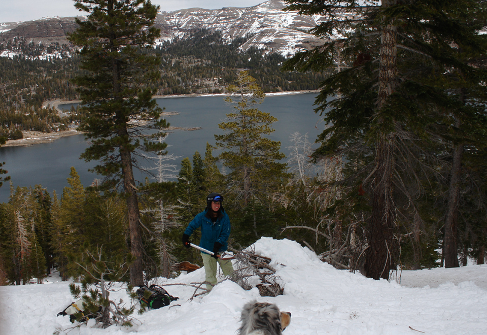
continued on powdork.comLast edited by powdork; 11-28-2012 at 01:54 AM.
powdork.com - new and improved, with 20% more dork.
-
11-28-2012, 01:46 AM #728
 Registered User
- Join Date
- Jan 2008
- Location
- truckee
- Posts
- 24,871
No matter how dark, or cold, or windy, or icy the dogs never try to bail, do they? They're hard to discourage. Originally Posted by powdork
-
11-28-2012, 03:31 AM #729
 Tahoe Rad ...as in MRI
- Join Date
- Dec 2004
- Location
- Incline Village, NV (Tahoe)
- Posts
- 5,438
It was just a double rainbow in the making. Originally Posted by dookey67
Hoping Squaw upper mountain will deliver some goods Thurs and Fri and....Every man dies. Not every man lives.
You don’t stop playing because you grow old; you grow old because you stop playing.
-
11-28-2012, 04:18 AM #730
 Registered User
- Join Date
- Aug 2011
- Location
- The City
- Posts
- 303
Jesus its incredible the amount of precip on the way. Mt rose might be decent. Not sure if they are open. We need a low to drop in and drop snow levels another 1000' at least for squaw lower mountain not get hammered by rain.
-
11-28-2012, 08:16 AM #731
 Gripped
- Join Date
- Sep 2012
- Location
- Berkeley, CA
- Posts
- 265
Thursday/Monday looking ok. Was hoping for some encouragement on Friday, but I'm not seeing it. NOAA Hourly Graphs showing solid precip and 80-90+ gusts at 8200 all day Friday.
Even nerdier weather guys, do those NOAA graphs come straight out of the GFS? Are there any similarly user friendly products from the other models?
-
11-28-2012, 09:12 AM #732
 Deepo days
- Join Date
- Jun 2007
- Location
- Cruzing
- Posts
- 12,172
1) I call that chopped up ice Vermont powder Originally Posted by dookey67
2) dude. Where have you been. There is a current discussion about the seriousness of vapor trails and such right here on TGR. Bone up. This stuff is important.
-
11-28-2012, 10:23 AM #733
Registered User
- Join Date
- May 2011
- Location
- Reno
- Posts
- 126
Rose has been open for a week, and has been skiing nicely considering it's still November. "Strong and damaging winds" in NOAA's forecast for Rose Saturday and Sunday, which likely means they'll only be spinning Lakeview (if that). Monday is looking good, though. Originally Posted by Wickedbrew4u
-
11-28-2012, 11:41 AM #734
 "The Harmonizer"
- Join Date
- Jul 2002
- Location
- Suckramento
- Posts
- 21,977
Looks a bit damp (from tahoeweatherdiscussion.com):
Not much change again this morning. I’ve seen some of the media saying massive rains and 11,000 ft. snow levels melting everything away. I’m not sure what they are looking at but the storms look much colder than that to me. Not as cold as we want but not 9000-11000 ft. snow levels.
Snow levels on some of the model runs stay down at 7000 ft. into Saturday with 1-3 feet of snow above that. We start today with a light snowfall event above 7000 ft. with snow possibly mixing down to lake level by this evening. 3-6 inches above 7000 ft. with a slushy coating down to 6500 ft.
The next storm moves in Thursday night into Friday with the trend being more Friday into Friday night. The trend has been colder with this system with snow levels around 7000 ft. We could see 1-3 feet above 7000 ft.
The biggest storm is later Saturday into Sunday. The models still don’t agree on where the heaviest precip is aimed. This is the storm where the snow levels jump up to 8000 ft. and maybe briefly higher Saturday night, and then crash to lake level by Sunday afternoon. This storm drops 3-6 inches of liquid so it will be a lot of rain below 8000 ft. Saturday night. Above that 2-4 ft. of heavy snow are possible. We could see several inches down to 7000 ft. Sunday as snow levels fall and a few even down to lake level. Total snowfall above 8000 ft. of 3-7 feet possible.
I will be monitoring the snow levels throughout the weekend and will keep you updated.
The long-range looks quiet after this weekend but the forecast models have been all over the place. A lot of complicated and contradicting signals in the teleconnections. Stay tuned…BAQuando paramucho mi amore de felice carathon.
Mundo paparazzi mi amore cicce verdi parasol.
Questo abrigado tantamucho que canite carousel.
-
11-28-2012, 11:44 AM #735
 SkiTalk.com
- Join Date
- Dec 2005
- Location
- SkiTalk.com
- Posts
- 3,375
At this point, We can say EXACTLY what happens with this storm..on Tuesday. It is gonna be what it is gonna be. So far the season is still better than last year (but not as good as the year before).
Click. Point. Chute.
-
11-28-2012, 11:50 AM #736
"The Harmonizer"
- Join Date
- Jul 2002
- Location
- Suckramento
- Posts
- 21,977
True there...raining in Truckee right now? Originally Posted by Flexon Phil
I find tahoeweatherdiscussion to be pretty accurateQuando paramucho mi amore de felice carathon.
Mundo paparazzi mi amore cicce verdi parasol.
Questo abrigado tantamucho que canite carousel.
-
11-28-2012, 11:57 AM #737
registered abuser
- Join Date
- Oct 2003
- Location
- tahoe
- Posts
- 3,428
14.5" in the 5 day qpf!!!
-
11-28-2012, 12:02 PM #738
Deepo days
- Join Date
- Jun 2007
- Location
- Cruzing
- Posts
- 12,172
That is a quality I like about you. You rarely, I ever, think it is too shitty to hike Originally Posted by powdork
-
11-28-2012, 12:09 PM #739
 Level 27 PSIA Tightass
- Join Date
- Sep 2006
- Location
- Truckee, CA
- Posts
- 9,437
10 a.m.ish and it just started raining in Truckee.
Squaw webcam for upper mountain just shows grey pictures, muted grey pictures, and pictures with grey augmented by globs (rain drops): http://www.squaw.com/the-mountain/conditions
Looking like it's gonna be a film festival day instead.
-
11-28-2012, 12:12 PM #740
Banned
- Join Date
- Jan 2009
- Location
- Reno
- Posts
- 1,344
I've long given up most chemtrail beliefs I held (there is a thing called geo engineering but it's not taking place over cities every day like most chemtrail kooks believe) Chemtrail tards are the most annoying type of conspiracy people out there. They literally think any lingering contrail is without a doubt the gov't spraying poison on them. Originally Posted by mcski
Quoting an entire series of large photographs twice in one page is HIGHLY annoying too (please take 2 extra seconds and quote 1 for the same effect)
-
11-28-2012, 01:05 PM #741
Tahoe Rad ...as in MRI
- Join Date
- Dec 2004
- Location
- Incline Village, NV (Tahoe)
- Posts
- 5,438
Rose and the wind forecast could put the Magnum and possibly Lakeview lifts may be on wind hold. Probably still too thin for them to open the Slide side. Originally Posted by Wickedbrew4u
 Every man dies. Not every man lives.
You don’t stop playing because you grow old; you grow old because you stop playing.
-
11-28-2012, 01:49 PM #742
Deepo days
- Join Date
- Jun 2007
- Location
- Cruzing
- Posts
- 12,172
Sorry to annoy you BG But not really. Sounds like you have a pretty low threshold for what annoys you. Life must be amazingly frustrating. It's the Internet. Just scroll down. I don't have a spare two seconds after typing this.
But I do apologize for being annoying and next time I won't quote from my phone were I can't tell the difference.Last edited by Ottime; 11-28-2012 at 02:29 PM.
-
11-28-2012, 02:10 PM #743
 Registered User
- Join Date
- Apr 2011
- Location
- Rasta Cruz
- Posts
- 174
Damn! It is dumping on the Kirkwood webcam. Let's hope it builds up before the rain comes.
-
11-28-2012, 02:17 PM #744
Banned
- Join Date
- Jan 2009
- Location
- Reno
- Posts
- 1,344
You're right. I enjoy quoted photo albums as of now. Enjoy! Originally Posted by powdork
-
11-28-2012, 02:18 PM #745
Banned
- Join Date
- Jan 2009
- Location
- Reno
- Posts
- 1,344
Just for good measure. Originally Posted by powdork
-
11-28-2012, 02:25 PM #746
 Registered User
- Join Date
- Dec 2006
- Posts
- 3,710
Thanks, Quadzilla! Originally Posted by Quadzilla
-
11-28-2012, 02:30 PM #747
Deepo days
- Join Date
- Jun 2007
- Location
- Cruzing
- Posts
- 12,172
Good fun.
Dumped down here real hard for a bit. Now it is pretty much as breezy as it gets.
BG. Come on. You clogging up the interwebz.
One more for good luck.
-
11-28-2012, 02:33 PM #748
 Win-win
- Join Date
- Nov 2007
- Location
- San Jose Cuervo
- Posts
- 747
MASHEDPOTATOES SCROLL FINGER IS TIRED NOW. PAGE 31 PLEASE.
-
11-28-2012, 02:40 PM #749WestCoastPDR Guest
Puking on the mt rose cams too. Elevation helps...
Sent from my SPH-L710 using TGR Forums
-
11-28-2012, 03:31 PM #750
Deepo days
- Join Date
- Jun 2007
- Location
- Cruzing
- Posts
- 12,172
Here ya go mashed. Pointless post from the coast to move us to the next page. Sun is out here
And can you please refrain from using all caps. It is the most annoying thing ever.

 Reply With Quote


Bookmarks