
Having a hard time trying to figure why the pc ridges have been avalanching.
Any ideas?
Results 376 to 400 of 1090
Thread: Wasatch 08-09 Conditions
-
12-20-2008, 07:44 PM #376
 Registered User
- Join Date
- Dec 2004
- Posts
- 493
-
12-20-2008, 11:40 PM #377
 skins miles for hardpack
- Join Date
- Mar 2008
- Posts
- 3,173
That happens in Utah? I thought it only happened here in MT.That sounds like the typical shit they say right before storms fizzle and split around us.
Happens every time we get a "winter storm warning". It's for sure it's fizzling and splitting when they give the warning. Hopefully when this one splits around you guys we get some here!
-
12-21-2008, 08:15 AM #378

 Irrie Rasta Dog Copilot
- Join Date
- Apr 2005
- Location
- A LSD Steakhouse somewhere in the Wasatch
- Posts
- 13,262
The dancing cloud sheep thingies blew all the snow over the ridge? Originally Posted by wra

nice Jinx "When the child was a child it waited patiently for the first snow and it still does"- Van "The Man" Morrison
"I find I have already had my reward, in the doing of the thing" - Buzz Holmstrom
"THIS IS WHAT WE DO"-AML -ski on in eternal peace
"I have posted in here but haven't read it carefully with my trusty PoliAsshat antenna on."-DipshitDanno
-
12-21-2008, 10:05 AM #379
 Quatsch!
- Join Date
- Sep 2005
- Location
- Wasatch Back: 7000'
- Posts
- 13,347
Well, it certainly can't be the perfect pitch, or the 40+ mile per hour winds, or the rain crust, or all that beautiful fluffy snow that has fallen (or been blown) on top of that crust...
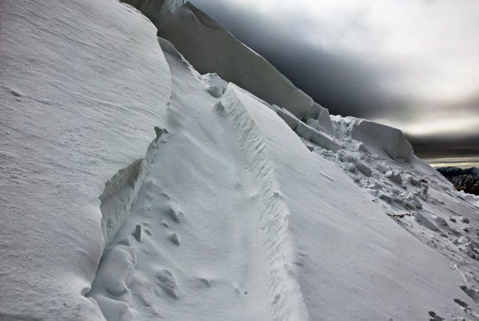
Have you seen SquareTop lately? Huge natural slide Thursday night. (900' wide 1500' vert)Last edited by schindlerpiste; 12-21-2008 at 10:09 AM.
“How does it feel to be the greatest guitarist in the world? I don’t know, go ask Rory Gallagher”. — Jimi Hendrix
-
12-21-2008, 02:47 PM #380
click click boom
- Join Date
- Nov 2001
- Posts
- 11,326
Better it happen in PC than anywhere with anything worth skiing.
-
12-21-2008, 03:30 PM #381
User
- Join Date
- Oct 2003
- Location
- Ogden
- Posts
- 9,854
Huge natural in MB cirque at the Basin the other day.
We skied the N. Lomond powder circuit today, winds were going nuclear above treeline. Stiff slabs forming on east thru north facing slopes below ridge-lines. Lots of whomping with whole slopes collapsing. The low angle stuff is still skiing well in sheltered areas.
In other news I really like the extended column test, it gives a good feel for the weak layer and the propagation potential.
-
12-21-2008, 06:47 PM #382
Registered User
- Join Date
- Dec 2004
- Posts
- 493
Hell, I thought maybe the snake oil man wuz up on 10420 filming more vids for the medicine show. Originally Posted by schindlerpiste
Didn't see Squaretop. Did manage to find a few slides. One about 600' wide?
No ects were done.

-
12-21-2008, 06:59 PM #383
click click boom
- Join Date
- Nov 2001
- Posts
- 11,326
The light in that photo is awesome. Nice work wra.
-
12-21-2008, 10:15 PM #384
 Skhipster
- Join Date
- Oct 2002
- Posts
- 2,787
This is either ignorant or clever. Originally Posted by truth
-
12-21-2008, 10:35 PM #385
 Registered User
- Join Date
- Jul 2006
- Location
- salt lake
- Posts
- 785
I have to second that quote. Did you adjust the photo, or was it just shot that way. Either way it looks cool! Originally Posted by truth
-
12-21-2008, 11:41 PM #386
click click boom
- Join Date
- Nov 2001
- Posts
- 11,326
I was going for sarcasm. Originally Posted by alto
-
12-22-2008, 07:44 AM #387
Irrie Rasta Dog Copilot
- Join Date
- Apr 2005
- Location
- A LSD Steakhouse somewhere in the Wasatch
- Posts
- 13,262
Bwah maybe a little over the top there but reading responses to threads like this one Originally Posted by wra
http://www.tetongravity.com/forums/s...d.php?t=144530
you would think the entire wasatch was above treeline and steeper than
30 degrees. Not saying shit aint dicey, but if you do get out there is some great snow science edumacation conditions.
Somebody should make a safe skiing in the wasatch book only it wouldn't sell cause gnar and sex sells.
Sweet pic Wow"When the child was a child it waited patiently for the first snow and it still does"- Van "The Man" Morrison
"I find I have already had my reward, in the doing of the thing" - Buzz Holmstrom
"THIS IS WHAT WE DO"-AML -ski on in eternal peace
"I have posted in here but haven't read it carefully with my trusty PoliAsshat antenna on."-DipshitDanno
-
12-22-2008, 10:32 AM #388
 Addicted Beater
- Join Date
- Jan 2005
- Location
- The Gorge
- Posts
- 1,062
I'd buy that book. I was thinking last night how I don't know of any meadow skipping stashes in the SLC, PC area. Originally Posted by skifishbum
-
12-22-2008, 10:35 AM #389
 Abuser
- Join Date
- Oct 2005
- Location
- Sandy
- Posts
- 5,374
Wasatch tours Volume 2 Originally Posted by ski_adk
-
12-22-2008, 03:53 PM #390
Hailstone, UT
- Join Date
- May 2006
- Posts
- 268
'Figured you were just jealous. Dumped in Orem today, I hope Provo Canyon stays open or I'm heading to the liquor store for some warm beer and sleeping at the office. Great day to drive into work...saw a gnarly wreck this morning. Originally Posted by truth
-
12-22-2008, 05:47 PM #391
 spreadin the love
- Join Date
- Feb 2004
- Location
- Big Cottonwood Country
- Posts
- 999
Mill-D to Reynolds Pk.
No PICS because wind and white out conditions today
Skinned up Mill-D 10:30am from the Spruces, took a run on short swing then headed up to Dog Lake and then up the ridge to Reynolds Pk.(Southwest summit from Dog Lake). Anyhoo, once I hit the ridge the wind was nuking and viz went to -O- Zero. I took a run NE then skinned back up to the summit then back out the skinner as to see my way back into the Mill-D home loop.
Still low snow on the North Side of BCC but some stashes were located with a little extra skinning. There is a prominent skinner all the way to the summit
-
12-22-2008, 05:58 PM #392
 shazaaam
- Join Date
- Nov 2007
- Location
- SLC no more.
- Posts
- 764
Sunday column test from the top of Short Swing if anyone's interested. Soft slab forming up there from the recent wind. At least the columns didn't fail before isolation....
-
12-22-2008, 06:27 PM #393
 gritty

- Join Date
- Dec 2005
- Location
- sl,ut
- Posts
- 477
so where is the prediction located that says it's going to snow 6 feet before New Years? Someone posted that on Facebook and I am hoping...well I won't tell you what I'm hoping, but put it this way: I leave and it starts DUMPING. Of course, but that happens to everyone right?
-
12-22-2008, 06:27 PM #394
Registered User
- Join Date
- Dec 2004
- Posts
- 493
Info that may actually be of some use.
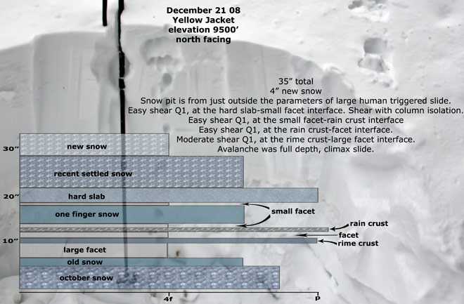
link to observationLast edited by wra; 12-22-2008 at 06:30 PM.
-
12-22-2008, 07:15 PM #395
User
- Join Date
- Oct 2003
- Location
- Ogden
- Posts
- 9,854
Cause everyone else's info is just shit, right? Originally Posted by wra
-
12-22-2008, 07:26 PM #396
Registered User
- Join Date
- Dec 2004
- Posts
- 493
I learned from Spread Eagle's post. I learned absolutely nothing from the video showing shovel taps in an area that had no snow prior to last week.
You don't have to look ya know, especially since I'm not an ecter, nor do I pay much attention to fluff and facade.
-
12-22-2008, 08:40 PM #397
 beater than you are
- Join Date
- Nov 2005
- Location
- Land of Brine Shrimp and Magic Underwear
- Posts
- 7,048
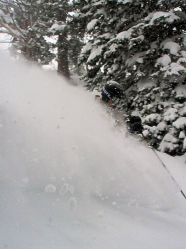
Top collins station shows .65" inches of H20 so far. Still Nuking when I got down at 5ish, should see some more by morning but I still don't know if the weight will be there for a mojor cycle. Till then I guess conitions will remain hair-trigger. I do know it was at least 3" an hour up there all afternoon. Seemed like this could be the storm of the season so far. We'll see if round 2 hits tonight or it peters out. So far it was pretty light and sloughy in spite of the high winds most of the day.
Good skiing though.There's nothing better than sliding down snow, flying through the air
-
12-22-2008, 11:38 PM #398
Irrie Rasta Dog Copilot
- Join Date
- Apr 2005
- Location
- A LSD Steakhouse somewhere in the Wasatch
- Posts
- 13,262
I observed the IceGrom had grown like 12 inches over the summer and isn't scorin face shots as easy.
Didn't learn all that much for these shots but they bring a hudge smile to my face similar to the one on this young lads face as he breaks in his season on a new pair of 164 bros


 "When the child was a child it waited patiently for the first snow and it still does"- Van "The Man" Morrison
"I find I have already had my reward, in the doing of the thing" - Buzz Holmstrom
"THIS IS WHAT WE DO"-AML -ski on in eternal peace
"I have posted in here but haven't read it carefully with my trusty PoliAsshat antenna on."-DipshitDanno
-
12-23-2008, 01:13 AM #399
 Powder Hugger


- Join Date
- Apr 2007
- Location
- Salt Lake City, UT
- Posts
- 630
-
12-23-2008, 04:24 AM #400
 Registered User
- Join Date
- Jun 2004
- Location
- On my way
- Posts
- 912
I'm not a snow nerd like you guys, so I don't know much about this stuff. Have some questions:
I don't understand the long term implications of a rain crust layer, once the faceted snow rounds out and bonds, the rain crust isnnt really an issue is it? Or will that rain crust keep a higher temperature gradient in the snow pack, making it take longer for the snow to bond?
kthnxbye

 Reply With Quote
Bookmarks