
says 4" in last 24hrs, 16" new this week that no one has rode yet. Thursday-Sunday will be great there, I'll be there for the weekend. Hopefully they open up to Billboard by then. Telluride got 8+", opened lift 12 and terrain under lift 6 today. Knee to thigh deep in places that haven't been rode all year. Hats off to ski patrol for ski packing stuff down and setting us up for this. Looks like Revelation Bowl and maybe some of Prospect Ridge tmw. Great day, face shots top to bottom. See you out there
Results 7,451 to 7,475 of 42780
-
12-14-2011, 03:39 PM #7451
 Registered User
- Join Date
- May 2010
- Location
- Telluride
- Posts
- 8
-
12-14-2011, 03:53 PM #7452
 Um, yeah, that guy


- Join Date
- Jan 2006
- Location
- Carbondale
- Posts
- 12,708
You think it'll be worth doing a guided day on Saturday, or just stick to the unguided stuff?
www.dpsskis.com
www.point6.com
formerly an ambassador for a few others, but the ski industry is... interesting.
Fukt: a very small amount of snow.
-
12-14-2011, 04:24 PM #7453
Registered User
- Join Date
- May 2010
- Location
- Telluride
- Posts
- 8
if you know the mountain unguided. I have the unguided pass there, didn't make it last weekend, but opening weekend they had almost the entire mountain open. So if you have partners and know the mountain I don't know of too many zones they would take you too that aren't open, or a long ass hike. Maybe into Nightmare or something whacky. But if they open everything to unguided I would do that
-
12-14-2011, 05:15 PM #7454
 Registered User
- Join Date
- Apr 2008
- Location
- Victor, ID
- Posts
- 737
got this from an accuweather blog showing the long range ECMWF model

-
12-14-2011, 05:43 PM #7455
 Death and Destruction
- Join Date
- Nov 2006
- Location
- ColoRADo
- Posts
- 5,957
If they got 16 feet overnight, I am quitting my job in the next 5 minutes Originally Posted by Z


Otherwise, no it has not been skied yet.You should have been here yesterday!
-
12-14-2011, 05:48 PM #7456
 Spar to Bar
- Join Date
- Jan 2009
- Location
- Aspen
- Posts
- 1,540
I have been to Silverton a few times but only once during the unguided season (January of this year) and I would definitely NOT recommend getting a guide if the unguided option is there. Originally Posted by grskier
Obviously this is anecdotal but the few runs our guy took us on that weren't open to the unguided skiers were nothing special, definitely not worth having to deal with someone telling you where to ski all day, potentially dealing with randoms in your group, and the extra $$ you have to pay for a guide.
Seems like this was all common knowledge too cuz the vast majority of people skiing that day were unguided. Every other time I was there I had a guide and it was sick so I booked a guided day, by the time my buds and I realized our mistake it was obviously too late.
-
12-14-2011, 05:56 PM #7457

 Registered User
- Join Date
- Oct 2003
- Location
- Aspen
- Posts
- 9,565
Soooooo far out, but THANK GOD! Originally Posted by BDKeg
-
12-14-2011, 11:18 PM #7458
Registered User
- Join Date
- Mar 2005
- Location
- Golden, CO!
- Posts
- 2,039
Joel, any thoughts to this? (posted in 2011/2012 Jackson Teton Weather/snow Thread)
Polar Vortex?
Originally Posted by neckdeep
-
12-15-2011, 07:32 AM #7459
 Rollin with the Tide
- Join Date
- May 2006
- Location
- Eagle County
- Posts
- 12,637
another 4" at Vail and 5" at the Beav. At least this week has brought something. The above sounds rather shitty, guess we'll just wait and see.
ROLL TIDE ROLL
-
12-15-2011, 08:32 AM #7460
 Steep and Deep
- Join Date
- Feb 2010
- Location
- Front Ranger
- Posts
- 903
^^ Amen to that. We will take anything at this point...
-
12-15-2011, 08:54 AM #7461
Registered User
- Join Date
- Mar 2009
- Location
- Boulder
- Posts
- 490
Re: Silverton reporting. I emailed Jen Brill about this. They have little/no internet connectivity up at the mountain, so reporting can be a challenge she said. Storm total is around 19-21", not skied til this morning. Enjoy it!
Re: the post of the polar vortex, as far as I can tell it's true.
Re: the ECMWF model for the next 2 weeks...I'm not holding my breath. Hopefully we come out of this pattern, and no matter, I'll stick to looking at the week ahead and not putting any money on the forecast further out because the models have sucked at long-range stuff this season. Cut-off and splitting storms seem to be hinted at through Jan 1.
Btw, just released our iPhone app! http://itun.es/iL22qR
- try it out
- if it works, give it a good review
- if it doesn't work, email me (joel@opensnow.com) and let me know
- it does 2 things: view/post pics to LiveSnow, and get push alerts for new snow or powder days
- to post to LiveSnow or get alerts, you need an OpenSnow.com account. Get one on the web before using the app
- I would have loved to get a full-fledged app out this season, but time/cost prevented that. So, the forecast, all reports, etc are all available on our mobile website which works on all smartphone browsers.
- The app is great to stay up-to-date on storms as you can view/post to LiveSnow and get snow/powder prediction alerts
Thanks for helping us out with good reviews or letting us know about bugs!
JOELThe artist formerly known as Colorado Powder Forecast: http://www.opensnow.com
-
12-15-2011, 09:28 AM #7462
Registered User
- Join Date
- Apr 2008
- Location
- Victor, ID
- Posts
- 737
4 inches at the resort in 48hrs here, 14 at irwin...the most depressing thing is that 4 inches will be 1 inch or less after baking in the sun for another 1+ weeks, lol Originally Posted by montanaskier
-
12-15-2011, 04:38 PM #7463
Registered User
- Join Date
- Oct 2003
- Location
- Aspen
- Posts
- 9,565
From our local weather guru....
I have looked at the models this morning and there are really no big changes to talk about. One quick mention concerning the extended weather pattern. It looks horrifically dry the rest of this month and I’m bowing to the weather gods everyday that this will change. I have been doing this a long time and this pattern is so atypical for a La Winter winter it makes me want to puke!! We have a slight chance for a minor change on Monday. The upper low that is now buried way down in southern Arizona will get kicked ENE by Monday. If it can come a touch further north we might be able to squeeze out a little snow. No promises yet because as usual there is no model agreement that far away. As of now I’m keeping it dry in the 6 day snow forecast but trying to stay positive as it could change. I will keep an eye on it!! Have a great day.
-
12-15-2011, 05:34 PM #7464
Rollin with the Tide
- Join Date
- May 2006
- Location
- Eagle County
- Posts
- 12,637
still looks like something around Christmas but that far out has been wrong almost every time this year. All the talk of the 10th, then the 17th, then Christmas....I doubt anything changes until mid Jan. Settle in and work on your carving.
this from NOAA sounds promising long term with the ridge moving but really really crappy short term
THE MID-RANGE MODELS REMAIN IN VERY GOOD AGREEMENT THROUGH NEXT
TUESDAY THEN DIVERGE. THE LONG WAVE PATTERN...WITH AN EASTERN
PACIFIC RIDGE FORCING PACIFIC ENERGY TO CLIMB INTO THE PACIFIC NW
THEN DIVE THROUGH THE GREAT BASIN...MAY FINALLY START EVOLVING
LATE NEXT WEEK.
SATURDAY NIGHT THE UPPER LOW...SPINNING NEAR SAN DIEGO...BEGINS
TO TRACK EAST. THE MODELS HAVE COMPROMISED WITH ITS PATH NOW
PROGGED TO SE AZ SUNDAY THEN LIFTING SLIGHTLY TO EAST-CENTRAL NM
BY MONDAY. THIS TRACK IS JUST FAR ENOUGH NORTH TO PRODUCE SOME
ISOLATED TO SCATTERED SHOWERS THROUGH THE SOUTHERN-MOST ZONES. BUT
A SUBTLE N/S SHIFT OF UPPER LOW WILL BRING MORE/LESS SHOWERS TO
THE SOUTHERN ZONES.
THE SHOWERS WILL END FROM WEST TO EAST LATE MONDAY AS THE NEXT
SPLITTING TROUGH DIVES SOUTH. THE SOUTHERN BRANCH QUICKLY CLOSES
OFF THE SOUTHERN CALIFORNIA COAST WHILE THE NORTHERN BRANCH
BRUSHES THE NORTHERN CWA WITHOUT ANY SENSIBLE WEATHER. THE CLOSED
LOW WILL AGAIN KICK ACROSS SONORA-AZ-NM LATE WEDNESDAY AS
ANOTHER...PERHAPS THE FINAL...PACIFIC WAVE DIVES SOUTH. THEN
THERE ARE HINTS THAT THE EASTERN PACIFIC RIDGE PROGRESSES ONSHORE
FOR POSSIBLY A DRY BENIGN WEATHER PATTERN INTO THE CHRISTMAS WEEKEND.ROLL TIDE ROLL
-
12-16-2011, 09:24 AM #7465
Registered User
- Join Date
- Mar 2009
- Location
- Boulder
- Posts
- 490
Next storm (after the one moving south of CO this Sun/Mon) will be on Thursday. Right now, looks like all of CO could see some snow. But this thing is splitting as well, and if it splits too far south and west, we're hosed. Ugh.
The artist formerly known as Colorado Powder Forecast: http://www.opensnow.com
-
12-16-2011, 09:53 AM #7466
Registered User
- Join Date
- Oct 2007
- Posts
- 13,651
gratzo, could you please just start making up predictions of massive storms coming our way? I mean, at least then we could get our hopes up and be in a good mood for a while before getting our dreams crushed by another disappointment.
-
12-16-2011, 10:40 AM #7467
 Time to Burn...
- Join Date
- Feb 2008
- Location
- On the back of the worm
- Posts
- 716
Joel- Good to see you last night. Hope you took home a nice prize.
I think I will be burn some skis this weekend...
-
12-16-2011, 02:05 PM #7468
 Registered User
- Join Date
- Oct 2010
- Posts
- 130
No to hijack the weather discussion thread, but my last minute decision to guided, over unguided at Silverton yesterday was probably the best call I ever made. I was the only skier that wanted a fast group, so I got a guide all to myself. We crushed either closed terrain or accessed unguided terrain just before it opened. Lift line cutting and radioed in pickups were also a plus. Solid 18-24" out there, but got really, really warm. I'd say there snow report was right on. Originally Posted by grskier
I have more skis and bikes than Facebook friends.
-
12-16-2011, 04:04 PM #7469
Um, yeah, that guy
- Join Date
- Jan 2006
- Location
- Carbondale
- Posts
- 12,708
We'll be there tomorrow.. it'll be a game time decision...
www.dpsskis.com
www.point6.com
formerly an ambassador for a few others, but the ski industry is... interesting.
Fukt: a very small amount of snow.
-
12-16-2011, 06:34 PM #7470
 born n raised in the CO
- Join Date
- Jan 2008
- Location
- Arrrvada, CO
- Posts
- 1,164
Weekend to do list.
1) Secure pics of red-haired wife for ULLR thread.
2) Burn old skis in sacrifice.
3) Route against 'Bama, just because (nothing personal montanaskier, I just fear that there could be leftover dealings with Satan that we are fighting).
4) Enjoy the beautiful weather on the Front Range and hit the Broncos game on Sunday.
I may not get the whole list checked off, but at least I will be trying. C'mon La Nina. At LEAST show up by New Years'. Originally Posted by RockBoy
Originally Posted by kannonbal
-
12-16-2011, 10:00 PM #7471
 Registered User
- Join Date
- Dec 2005
- Location
- Front Range, CO
- Posts
- 704
How was Mary Jane opening today?
-
12-16-2011, 11:06 PM #7472
 recovering never nude
- Join Date
- Feb 2004
- Posts
- 3,746
What made you decide to go guided last minute?
I wouldn't worry about a hijack given the current weather situation. :/
Originally Posted by mfkracing
I french kissed Kelly Kapowski.
-
12-17-2011, 10:26 AM #7473
Registered User
- Join Date
- Mar 2009
- Location
- Boulder
- Posts
- 490
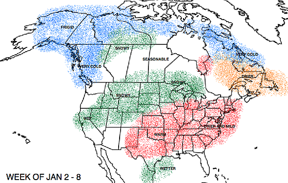
Quick article/graphic about the current storm track:
http://opensnow.com/blog/2011/12/wheres-the-snow/
In other news, there have now been 4 model runs that hint at a bit of a pattern shift around New years. This is still a 15 day forecast, so I trust it at about 1%. But, it does show the jet stream coming more west-to-east into the west coast, versus this cut-off BS we've seen over the last 2 months. I am NOT excited about this yet, but it does provide some Tebow-like hope that things will be snowier in January.The artist formerly known as Colorado Powder Forecast: http://www.opensnow.com
-
12-17-2011, 11:17 AM #7474
Rollin with the Tide
- Join Date
- May 2006
- Location
- Eagle County
- Posts
- 12,637
until it snows...I'm not buying it. Sounds like that high has to move inland first which would then mean a big Omega high and that would have to break down and move east before it could snow. We'll see....but we need like 3 or 4 feet just to get things kinda started.
from the Teton thread on the front page:
This is what the weather gurus are looking at. Prolonged snowy weather at the mid latitudes of north america correlates strongly with negative AO phase. As you can see, most of the models in the ensemble are predicting a return to high positive phase values for another two weeks. There's also a 1-2 week lag between changes in AO and results in the lower 48. As for significant pattern changes upstream of the Tetons, if the AO forecast is correct, it is likely that the high pressure ridge established in the east pacific will be the dominant feature in our weather for 2-4 more weeks. NOAA predicted a snowy december for the central rockies based on past ENSO patterns but the AO has been exerting the greater pull on the jet stream. Two weeks back AO was at +4 and if you look at the table of averages, you'll see how unusually high this signal is. Basically, NOAA's wet winter forecast for the Tetons is out the window while this is going on. The last three weeks have been proof enough of that for me.
Gonna be a very, very, very, long 3-4 more weeks at least it seems.Last edited by montanaskier; 12-17-2011 at 12:40 PM.
ROLL TIDE ROLL
-
12-17-2011, 12:57 PM #7475
 Registered User
- Join Date
- Sep 2009
- Location
- MST
- Posts
- 681
^^^ As always, appreciate the info, but that is really fucking depressing.
go upside down.

 Reply With Quote
Similar Threads
-
Up to the Minute Colorado Backcountry Weather Conditions
By AzureAbyss in forum General Ski / Snowboard DiscussionReplies: 13Last Post: 03-07-2011, 11:16 PM -
anti jinx, anti jinx, anti jinx thread
By Benny Profane in forum General Ski / Snowboard DiscussionReplies: 0Last Post: 02-10-2006, 12:34 AM -
The Colorado crew STOKE thread.
By Blurred Elevens in forum TGR Forum ArchivesReplies: 18Last Post: 07-12-2004, 11:16 PM -
a REPLY without a thread...
By Endlessseason in forum TGR Forum ArchivesReplies: 12Last Post: 10-28-2003, 09:44 AM

Bookmarks